THE ADVENTURE COLLECTIVE® · Independent discovery and booking for outdoor travel

Follow a grassy ridge from Lâm Đồng highlands to Bình Thuận’s pine foothills on the Tà Năng–Phan Dũng trek. This 2-day point-to-point route mixes open meadows, basalt ridges and simple village culture—ideal for hikers who want wild views with pragmatic logistics.
Follow a grassy ridge from Lâm Đồng highlands to Bình Thuận’s pine foothills on the Tà Năng–Phan Dũng trek. This 2-day point-to-point route mixes open meadows, basalt ridges and simple village culture—ideal for hikers who want wild views with pragmatic logistics.
A damp dawn breaks over a long green spine of grass and pine; the ridge ahead narrows to a single file of footsteps and the trail pushes you from montane scrub toward lowland pine forests. The Tà Năng–Phan Dũng route is a linear, point-to-point trek that links highland plateaus in Lâm Đồng with the coastal foothills of Bình Thuận, offering sudden panoramas and wide meadows where wind says more than birds.
Verified experiences and guided adventures in the surrounding area.
Operated by TO ONG ADVENTURE · Tà Năng, Lâm Đồng
A damp dawn breaks over a long green spine of grass and pine; the ridge ahead narrows to a single file of footsteps and the trail pushes you from montane scrub toward lowland pine forests. The Tà Năng–Phan Dũng route is a linear, point-to-point trek that links highland plateaus in Lâm Đồng with the coastal foothills of Bình Thuận, offering sudden panoramas and wide meadows where wind says more than birds.
Geology here is a patchwork of weathered basalt, lateritic soils and sandstone outcrops that create grassy saddles and narrow cols. Historically the path threaded local trade and seasonal grazing, and today small farming villages along the way still practice rice-and-vegetable rotations and cattle grazing. Guides often point out simple cultural markers — field terraces, village shrines — that frame human life against open sky.
On the ground, expect persistent uphill and downhill sections, grassy ridgelines that can be slick after rain, and pine-dominated campsites with limited shade. The trail is best taken over two days with basic camping; the tour commonly provides tents, sleeping bags and a guide. Practical planning: pack waterproof layers and sturdy boots with ankle support, carry 2–3 liters of water or purification tablets, and plan camps early to avoid afternoon storms. Move deliberately across exposed sections; the wind will remind you to tighten your pack straps and keep a low profile. With sensible preparation, the Tà Năng–Phan Dũng trek delivers a compact wilderness experience that shifts visually between highland meadow and coastal pine, rewarding effort with long, empty horizons.
moderate.
2 days (approx. 48 hours).
Moderate endurance required: regular walkers who can manage 6–10 hours of hiking across rough terrain.
Most organized trips cover the route in 2 days (point-to-point) with camping; independent hikers sometimes extend it to 3 days to move at a gentler pace.
A local guide is strongly recommended for logistics, local knowledge and safety; permits are not typically required but organized tours often manage access and transport.
Weather is variable—cool mornings and evenings in the highlands, with frequent afternoon showers in the wet season (May–October) and clearer, drier conditions in the dry season (December–March).
Fit beginners who have prior day-hiking experience can complete it with a guided group, but it's not recommended for those with serious back or heart problems due to long hours and carrying a pack.
The route links small Highland and coastal communities and has long been used for seasonal grazing and local trade, reflecting a mix of ethnic Kinh and minority livelihoods.
Visitor numbers have grown; follow leave-no-trace practices, camp on durable surfaces, and support local guides and waste-reduction efforts to minimize impact.
TO ONG ADVENTURE operates guided outdoor trips and adventures with an emphasis on safety, stewardship, and memorable experiences.
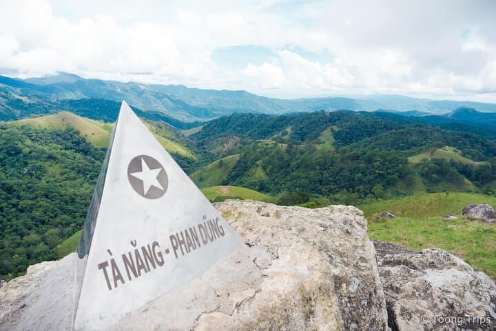


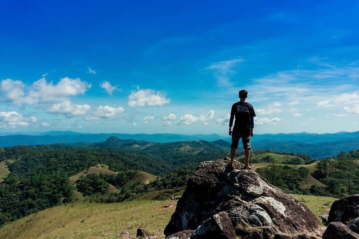
A damp dawn breaks over a long green spine of grass and pine; the ridge ahead narrows to a single file of footsteps and the trail pushes you from montane scrub toward lowland pine forests. The Tà Năng–Phan Dũng route is a linear, point-to-point trek that links highland plateaus in Lâm Đồng with the coastal foothills of Bình Thuận, offering sudden panoramas and wide meadows where wind says more than birds.
A damp dawn breaks over a long green spine of grass and pine; the ridge ahead narrows to a single file of footsteps and the trail pushes you from montane scrub toward lowland pine forests. The Tà Năng–Phan Dũng route is a linear, point-to-point trek that links highland plateaus in Lâm Đồng with the coastal foothills of Bình Thuận, offering sudden panoramas and wide meadows where wind says more than birds.
Geology here is a patchwork of weathered basalt, lateritic soils and sandstone outcrops that create grassy saddles and narrow cols. Historically the path threaded local trade and seasonal grazing, and today small farming villages along the way still practice rice-and-vegetable rotations and cattle grazing. Guides often point out simple cultural markers — field terraces, village shrines — that frame human life against open sky.
On the ground, expect persistent uphill and downhill sections, grassy ridgelines that can be slick after rain, and pine-dominated campsites with limited shade. The trail is best taken over two days with basic camping; the tour commonly provides tents, sleeping bags and a guide. Practical planning: pack waterproof layers and sturdy boots with ankle support, carry 2–3 liters of water or purification tablets, and plan camps early to avoid afternoon storms. Move deliberately across exposed sections; the wind will remind you to tighten your pack straps and keep a low profile. With sensible preparation, the Tà Năng–Phan Dũng trek delivers a compact wilderness experience that shifts visually between highland meadow and coastal pine, rewarding effort with long, empty horizons.