THE ADVENTURE COLLECTIVE® · Independent discovery and booking for outdoor travel

A compact two-day ascent from Imlil to the 4,167 m summit of Mount Toubkal, this trek pairs high-altitude terrain with Amazigh village culture and refuge-style overnighting. Expect steep approaches, rocky scree, and sunrise views that make the early start worth it.
A compact two-day ascent from Imlil to the 4,167 m summit of Mount Toubkal, this trek pairs high-altitude terrain with Amazigh village culture and refuge-style overnighting. Expect steep approaches, rocky scree, and sunrise views that make the early start worth it.
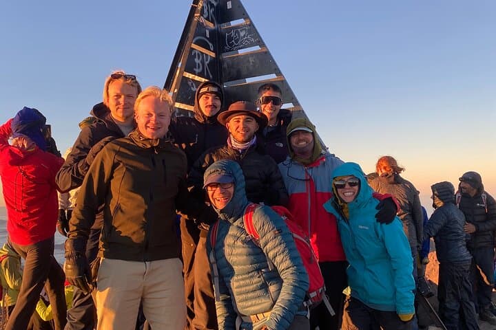
Moonlight skims the broken ridge as you leave the refuge at 4:00 AM, headlamp beams cutting through cold alpine air while the Atlas massif holds its breath. By sunrise the silhouette of Jbel Toubkal—North Africa’s highest summit—floods the valley in hard light; the final pitch is a scramble over loose scree and wind-polished rock that rewards every upward step with widening panoramas.
Verified experiences and guided adventures in the surrounding area.
Operated by Atlas Toubkal Trek · Imlil, Marrakech-Safi
Moonlight skims the broken ridge as you leave the refuge at 4:00 AM, headlamp beams cutting through cold alpine air while the Atlas massif holds its breath. By sunrise the silhouette of Jbel Toubkal—North Africa’s highest summit—floods the valley in hard light; the final pitch is a scramble over loose scree and wind-polished rock that rewards every upward step with widening panoramas.
The High Atlas is the result of tectonic uplift where folded sedimentary and metamorphic rocks were pushed skyward; human history here is written in the terraced fields and stone houses of Amazigh (Berber) villages that line the mule tracks. Chamharouch and Imlil are working mountain hamlets where tea and simple hospitality anchor the cultural side of the route.
Expect two compact days of mountain travel: day one climbs from Imlil (~1,740 m) to the Toubkal Refuge (~3,200 m) with roughly 1,400–1,500 m elevation gain over 8–10 km of mule and foot trail. Day two starts pre-dawn for ~900–1,000 m of ascent to 4,167 m and a technical but non-technical descent back to Imlil.
Trails move from shaded juniper and almond groves to rocky talus and occasional snowfields; weather can swing fast—wind and cold will test gear choices. Practical preparation pays: firm boots, layered clothing, ample water, and a steady pace for altitude. Guided parties typically include mules, refuge sleeping, and local guides who know route and rhythm—making a two-day summit both achievable and deeply memorable.
challenging.
2 days (10–14 hours active total).
Good cardiovascular fitness and experience with full-day hikes at sustained uphill grade; comfortable on loose scree.
No technical mountaineering skills are required for the normal route—strong fitness, good boots, and comfort on loose rock are the key requirements.
Rapid ascent increases risk; the two-day schedule is commonly done but can bring mild symptoms—drink plenty, rest, and communicate with your guide if you feel unwell.
Expect a basic mountain refuge with dorm-style sleeping, communal meals, and simple facilities; some groups use local guesthouses in Imlil instead.
Late spring to early autumn offers the most stable conditions, but winter attracts snow-seekers—be prepared for cold, and consider guided trips with snow equipment.
The High Atlas has long been inhabited by Amazigh communities who maintain terraced agriculture and mountain trade routes; modern trekking routes grew with 20th-century European interest in the range.
High-altitude vegetation and fragile water sources are vulnerable—stick to established trails, pack out waste, and use local guides to support sustainable tourism.
Atlas Toubkal Trek operates guided outdoor trips and adventures with an emphasis on safety, stewardship, and memorable experiences.

Moonlight skims the broken ridge as you leave the refuge at 4:00 AM, headlamp beams cutting through cold alpine air while the Atlas massif holds its breath. By sunrise the silhouette of Jbel Toubkal—North Africa’s highest summit—floods the valley in hard light; the final pitch is a scramble over loose scree and wind-polished rock that rewards every upward step with widening panoramas.
Moonlight skims the broken ridge as you leave the refuge at 4:00 AM, headlamp beams cutting through cold alpine air while the Atlas massif holds its breath. By sunrise the silhouette of Jbel Toubkal—North Africa’s highest summit—floods the valley in hard light; the final pitch is a scramble over loose scree and wind-polished rock that rewards every upward step with widening panoramas.
The High Atlas is the result of tectonic uplift where folded sedimentary and metamorphic rocks were pushed skyward; human history here is written in the terraced fields and stone houses of Amazigh (Berber) villages that line the mule tracks. Chamharouch and Imlil are working mountain hamlets where tea and simple hospitality anchor the cultural side of the route.
Expect two compact days of mountain travel: day one climbs from Imlil (~1,740 m) to the Toubkal Refuge (~3,200 m) with roughly 1,400–1,500 m elevation gain over 8–10 km of mule and foot trail. Day two starts pre-dawn for ~900–1,000 m of ascent to 4,167 m and a technical but non-technical descent back to Imlil.
Trails move from shaded juniper and almond groves to rocky talus and occasional snowfields; weather can swing fast—wind and cold will test gear choices. Practical preparation pays: firm boots, layered clothing, ample water, and a steady pace for altitude. Guided parties typically include mules, refuge sleeping, and local guides who know route and rhythm—making a two-day summit both achievable and deeply memorable.