THE ADVENTURE COLLECTIVE® · Independent discovery and booking for outdoor travel

Turn Melbourne’s Hoddle Grid into a game: this self-guided scavenger hunt uses an app to lead you through laneways, arcades and civic squares while you solve clues and photograph creative tasks. Perfect for first-time visitors who want a brisk, playful orientation of the CBD.
Turn Melbourne’s Hoddle Grid into a game: this self-guided scavenger hunt uses an app to lead you through laneways, arcades and civic squares while you solve clues and photograph creative tasks. Perfect for first-time visitors who want a brisk, playful orientation of the CBD.
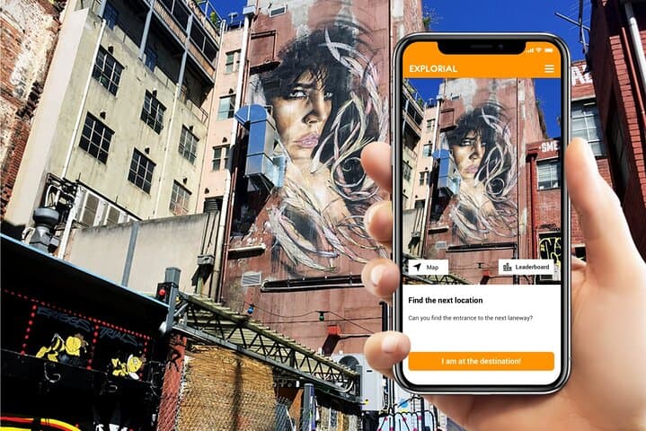
You start at the step-front of Flinders Street Station where morning light bounces off the clock and tram bells score your first clues. The city’s laneways hush and hum at once — a narrow corridor of coffee steam, tilework, and spray-painted walls daring you to look closer. Follow the Explorial app’s map; each riddle pushes you deeper into alleys, arcades and past the Majorca Building’s patterned façade.
Verified experiences and guided adventures in the surrounding area.
Operated by Explorial · Melbourne, Victoria
You start at the step-front of Flinders Street Station where morning light bounces off the clock and tram bells score your first clues. The city’s laneways hush and hum at once — a narrow corridor of coffee steam, tilework, and spray-painted walls daring you to look closer. Follow the Explorial app’s map; each riddle pushes you deeper into alleys, arcades and past the Majorca Building’s patterned façade.
Melbourne’s centre sits on the Yarra River floodplain, laid out as the Hoddle Grid in 1837. Evidence of the city’s rapid Victorian-era growth is visible in sandstone facades and early-20th-century civic structures, while post-war layers of street art and modernist squares show a living urban geology of culture and craft.
The scavenger-hunt format flips a standard walking tour into a game: identify signage, photograph creative prompts and answer questions that are literally written into the fabric of the city. Along the route expect Federation Square’s modern concrete plane, the tile mosaics of the Majorca Building, and Hosier Lane’s ever-changing murals. Coffee carts, tram stops and small courtyards provide natural pause points.
Practicalities: this is low-impact walking for most fitness levels, roughly 1–2 hours depending on how deep you dive. You’ll need a smartphone, charged and with data, comfortable shoes, and a weather layer — Melbourne’s weather shifts fast. Public transport connects easily to the start; take care crossing tram tracks and keep belongings secure in busy laneways. The result is part city orientation, part puzzle: an efficient, playful way to read Melbourne on your feet.
easy.
1–2 hours.
Suitable for most people who can walk on flat urban surfaces for up to two hours
Most groups finish in 1–2 hours depending on pace and how many photo tasks you attempt; the experience isn’t time-limited so you can stop and explore.
Start points are in the CBD near Flinders Street Station; the app provides the exact starting coordinates and a suggested route but you can finish anywhere along the map.
Yes — download the Explorial app and redeem your access code before you arrive; ensure your phone has data or Wi‑Fi for maps and clues.
The route is on paved city streets and is rated easy, but some laneways may be narrow; it’s family-friendly if participants can walk short urban distances.
The Hoddle Grid laid out Melbourne’s CBD in 1837; Victorian-era growth and later civic projects created many of the arcades and public buildings you’ll see.
The city works to reduce litter and protect the Yarra’s health; stick to designated bins and avoid feeding birds to limit wildlife disruption.
Explorial operates guided outdoor trips and adventures with an emphasis on safety, stewardship, and memorable experiences.

You start at the step-front of Flinders Street Station where morning light bounces off the clock and tram bells score your first clues. The city’s laneways hush and hum at once — a narrow corridor of coffee steam, tilework, and spray-painted walls daring you to look closer. Follow the Explorial app’s map; each riddle pushes you deeper into alleys, arcades and past the Majorca Building’s patterned façade.
You start at the step-front of Flinders Street Station where morning light bounces off the clock and tram bells score your first clues. The city’s laneways hush and hum at once — a narrow corridor of coffee steam, tilework, and spray-painted walls daring you to look closer. Follow the Explorial app’s map; each riddle pushes you deeper into alleys, arcades and past the Majorca Building’s patterned façade.
Melbourne’s centre sits on the Yarra River floodplain, laid out as the Hoddle Grid in 1837. Evidence of the city’s rapid Victorian-era growth is visible in sandstone facades and early-20th-century civic structures, while post-war layers of street art and modernist squares show a living urban geology of culture and craft.
The scavenger-hunt format flips a standard walking tour into a game: identify signage, photograph creative prompts and answer questions that are literally written into the fabric of the city. Along the route expect Federation Square’s modern concrete plane, the tile mosaics of the Majorca Building, and Hosier Lane’s ever-changing murals. Coffee carts, tram stops and small courtyards provide natural pause points.
Practicalities: this is low-impact walking for most fitness levels, roughly 1–2 hours depending on how deep you dive. You’ll need a smartphone, charged and with data, comfortable shoes, and a weather layer — Melbourne’s weather shifts fast. Public transport connects easily to the start; take care crossing tram tracks and keep belongings secure in busy laneways. The result is part city orientation, part puzzle: an efficient, playful way to read Melbourne on your feet.