THE ADVENTURE COLLECTIVE® · Independent discovery and booking for outdoor travel

Launch from a ridge above Baños for a 15-minute tandem paragliding flight with sweeping views of Tungurahua volcano and the Pastaza valley. Expect an expert briefing, English/Spanish guides, and a short but unforgettable aerial perspective of this thermal town.
Launch from a ridge above Baños for a 15-minute tandem paragliding flight with sweeping views of Tungurahua volcano and the Pastaza valley. Expect an expert briefing, English/Spanish guides, and a short but unforgettable aerial perspective of this thermal town.
You lift off from a grassy ridge and the city of Baños drops away beneath you—roofs, river bends and the thermal steam rise like a map unrolling. The air here has a clean, volcanic edge; wind buffers and thermals take hold and the guides adjust the wing with practiced calm. For about 15 minutes you fly in tandem, drifting above orchards and the Pastaza River with the cone of Tungurahua looming to the south, occasionally spitting steam like a restless neighbor.
Verified experiences and guided adventures in the surrounding area.
Operated by Parapente Montanita · Baños de Agua Santa, Tungurahua
You lift off from a grassy ridge and the city of Baños drops away beneath you—roofs, river bends and the thermal steam rise like a map unrolling. The air here has a clean, volcanic edge; wind buffers and thermals take hold and the guides adjust the wing with practiced calm. For about 15 minutes you fly in tandem, drifting above orchards and the Pastaza River with the cone of Tungurahua looming to the south, occasionally spitting steam like a restless neighbor.
Baños de Agua Santa grew as a hot-springs town and gateway to the eastern Andes; the valley’s deep river cuts and craggy ridgelines are recent chapters in a landscape still shaped by Tungurahua’s eruptions. Paragliding routes favor ridgelines that catch upslope winds—pilots read the sky like a local language. Guides speak English and Spanish and will brief you on takeoff, signals, and landing before you go airborne.
Practical guidance: plan for early-morning or late-afternoon flights when thermals are predictable and light is best for photos. Wear sturdy shoes for the short run at takeoff, a windproof layer, and secure your phone or camera with a strap. Operators screen for weight, height, and medical restrictions; pregnant travelers and those with serious spine or heart conditions should not fly.
The flight is short but concentrated—expect adrenaline, steady panoramic views, and a grounded briefing before and after. Book with an operator who cancels in poor weather and who prioritizes briefings and safe landing zones.
moderate.
1–2 hours (15-minute flight).
Light fitness and mobility: able to run a short takeoff and stand for landing.
The airborne portion is about 15 minutes; allow 1–2 hours total for briefing, harnessing and transfers.
No—this is a tandem flight with a certified guide; basic mobility and following instructions are sufficient.
Operators will collect height, weight and health info; not suitable for pregnant travelers or those with serious spinal or cardiovascular conditions.
Flights are canceled or rescheduled in unsafe wind or rain; reputable operators will refund or offer alternatives.
Baños developed around natural hot springs and became a staging point for explorers traveling between the highlands and Amazon; Tungurahua’s activity has long shaped local life.
Choose operators who respect flight corridors and landing sites to minimize disturbance; pack out waste and follow local trail and river access rules.
Parapente Montanita operates guided outdoor trips and adventures with an emphasis on safety, stewardship, and memorable experiences.
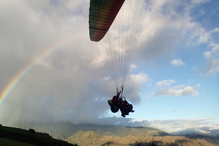


You lift off from a grassy ridge and the city of Baños drops away beneath you—roofs, river bends and the thermal steam rise like a map unrolling. The air here has a clean, volcanic edge; wind buffers and thermals take hold and the guides adjust the wing with practiced calm. For about 15 minutes you fly in tandem, drifting above orchards and the Pastaza River with the cone of Tungurahua looming to the south, occasionally spitting steam like a restless neighbor.
You lift off from a grassy ridge and the city of Baños drops away beneath you—roofs, river bends and the thermal steam rise like a map unrolling. The air here has a clean, volcanic edge; wind buffers and thermals take hold and the guides adjust the wing with practiced calm. For about 15 minutes you fly in tandem, drifting above orchards and the Pastaza River with the cone of Tungurahua looming to the south, occasionally spitting steam like a restless neighbor.
Baños de Agua Santa grew as a hot-springs town and gateway to the eastern Andes; the valley’s deep river cuts and craggy ridgelines are recent chapters in a landscape still shaped by Tungurahua’s eruptions. Paragliding routes favor ridgelines that catch upslope winds—pilots read the sky like a local language. Guides speak English and Spanish and will brief you on takeoff, signals, and landing before you go airborne.
Practical guidance: plan for early-morning or late-afternoon flights when thermals are predictable and light is best for photos. Wear sturdy shoes for the short run at takeoff, a windproof layer, and secure your phone or camera with a strap. Operators screen for weight, height, and medical restrictions; pregnant travelers and those with serious spine or heart conditions should not fly.
The flight is short but concentrated—expect adrenaline, steady panoramic views, and a grounded briefing before and after. Book with an operator who cancels in poor weather and who prioritizes briefings and safe landing zones.