THE ADVENTURE COLLECTIVE® · Independent discovery and booking for outdoor travel

Walk 7 km through Vienna’s siege sites with a GPS-driven mobile game that blends puzzles and history. From St. Stephen’s to Kahlenberg, this self-guided tour turns cobbled streets into a living battlefield.
Walk 7 km through Vienna’s siege sites with a GPS-driven mobile game that blends puzzles and history. From St. Stephen’s to Kahlenberg, this self-guided tour turns cobbled streets into a living battlefield.
A cold breeze threads between Gothic spires as you step out beneath St. Stephen’s Cathedral; cobblestones click underfoot and your phone vibrates with the first clue. The app drops you into 1683 Vienna—no guide, only GPS waypoints, puzzles, and the city's own stones to tell the story.
Verified experiences and guided adventures in the surrounding area.
Operated by Leplace - interactive self-guided app tours · Vienna, Vienna
A cold breeze threads between Gothic spires as you step out beneath St. Stephen’s Cathedral; cobblestones click underfoot and your phone vibrates with the first clue. The app drops you into 1683 Vienna—no guide, only GPS waypoints, puzzles, and the city's own stones to tell the story.
The route follows 7 km of historic streets and defensive lines, moving from Stephansplatz through Stubentor and the Wien Museum toward the Augustinerbastei before finishing on Kahlenberg ridge. Vienna’s urban geology—sandstone and river deposits of the Vienna Basin—frames narrow alleys and broad plazas where civic drama played out. Cultural notes arrive in short, sharp bursts: militia headquarters once met diplomats in Minoritenplatz, and a cannonball still sits embedded in a wall as a blunt memory of the Ottoman assault. The human history is immediate: supply lines, siege tactics, and the cavalry charge led by King John III Sobieski and his Winged Hussars.
Practically, expect mostly paved city walking with one steady climb to Kahlenberg (roughly 300–350 m net gain if you include the ascent). The app is point-to-point: solve puzzles, read micro-histories, and pause at cafés when you need a break. Public transport links let you skip or rejoin segments. Wear grippy shoes for uneven cobbles, bring a charger and local data or offline maps, and allow 1–2 hours depending on stops. The experience blends sightseeing, mild cardio, and a scavenger-hunt pace—ideal for curious travelers who want history on their own terms.
easy.
1–2 hours.
Light walking fitness; comfortable on your feet for up to two hours and able to manage short stair sections and an urban hill climb.
No—this is a self-guided mobile experience; you can begin whenever the app is available and proceed at your own pace.
Much of central Vienna is paved, but cobbles, stairs, and the Kahlenberg climb make the full route unsuitable for many wheelchairs or reduced-mobility travelers.
The itinerary covers about 7 km with an estimated duration of 1–2 hours depending on stops; include extra time for museums or cafés.
The app uses GPS and interactive content—mobile data is recommended, but download any available offline content and maps if you prefer.
Vienna’s 1683 defense ended when relief forces led by Polish King John III Sobieski and his Winged Hussars broke the Ottoman siege, a turning point in Central European history.
Stick to marked streets and historic pathways, avoid touching or climbing on masonry relics, and use the app’s digital guide to reduce paper use and foot traffic impact.
Leplace - interactive self-guided app tours operates guided outdoor trips and adventures with an emphasis on safety, stewardship, and memorable experiences.
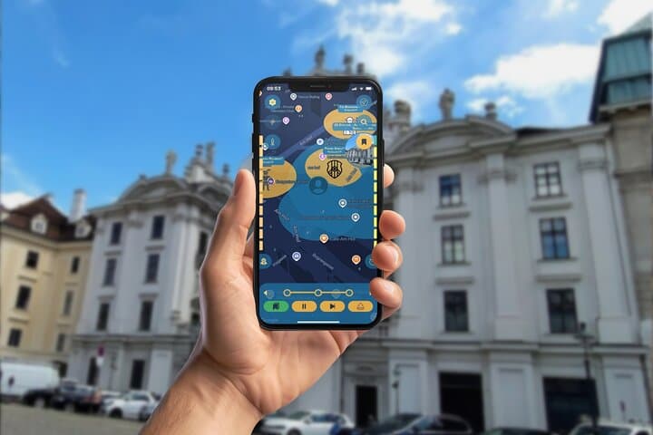

A cold breeze threads between Gothic spires as you step out beneath St. Stephen’s Cathedral; cobblestones click underfoot and your phone vibrates with the first clue. The app drops you into 1683 Vienna—no guide, only GPS waypoints, puzzles, and the city's own stones to tell the story.
A cold breeze threads between Gothic spires as you step out beneath St. Stephen’s Cathedral; cobblestones click underfoot and your phone vibrates with the first clue. The app drops you into 1683 Vienna—no guide, only GPS waypoints, puzzles, and the city's own stones to tell the story.
The route follows 7 km of historic streets and defensive lines, moving from Stephansplatz through Stubentor and the Wien Museum toward the Augustinerbastei before finishing on Kahlenberg ridge. Vienna’s urban geology—sandstone and river deposits of the Vienna Basin—frames narrow alleys and broad plazas where civic drama played out. Cultural notes arrive in short, sharp bursts: militia headquarters once met diplomats in Minoritenplatz, and a cannonball still sits embedded in a wall as a blunt memory of the Ottoman assault. The human history is immediate: supply lines, siege tactics, and the cavalry charge led by King John III Sobieski and his Winged Hussars.
Practically, expect mostly paved city walking with one steady climb to Kahlenberg (roughly 300–350 m net gain if you include the ascent). The app is point-to-point: solve puzzles, read micro-histories, and pause at cafés when you need a break. Public transport links let you skip or rejoin segments. Wear grippy shoes for uneven cobbles, bring a charger and local data or offline maps, and allow 1–2 hours depending on stops. The experience blends sightseeing, mild cardio, and a scavenger-hunt pace—ideal for curious travelers who want history on their own terms.