THE ADVENTURE COLLECTIVE® · Independent discovery and booking for outdoor travel

Navigate Banff, Jasper and Yoho at your own pace with a multilingual audio guide and map-linked routes. Download the Tourist Road Guide app, preload routes and use geolocated narration for driving legs, short walks and alpine hikes.
Navigate Banff, Jasper and Yoho at your own pace with a multilingual audio guide and map-linked routes. Download the Tourist Road Guide app, preload routes and use geolocated narration for driving legs, short walks and alpine hikes.
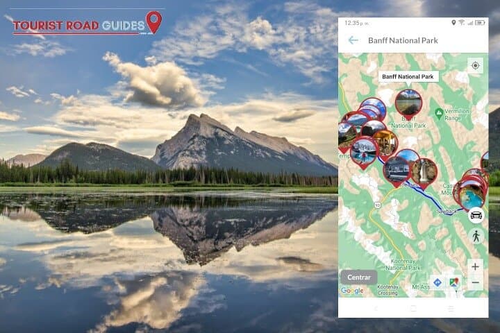
A low sun slides across the Icefields Parkway as you tap play and the app’s voice nudges you toward the next turnout. The route unfolds on the map—lakes shuttered in glass, glaciers draping high ridgelines, and forested valleys that seem to hold their breath. This audio guide packages driving legs and walking routes across Banff, Jasper and Yoho into self-paced narration with geolocation and linked Google Map pins.
Verified experiences and guided adventures in the surrounding area.
Operated by BARCELONA LANDS · Banff, Alberta
A low sun slides across the Icefields Parkway as you tap play and the app’s voice nudges you toward the next turnout. The route unfolds on the map—lakes shuttered in glass, glaciers draping high ridgelines, and forested valleys that seem to hold their breath. This audio guide packages driving legs and walking routes across Banff, Jasper and Yoho into self-paced narration with geolocation and linked Google Map pins.
The landscape here is shaped by ice and time: ancient sedimentary layers tilted by the Rocky Mountain orogeny and carved by Pleistocene glaciers into cirques, U-shaped valleys and the broad, blue basins of alpine lakes. Cultural threads run through the narration too, from Indigenous stewardship by the Stoney, Secwépemc and other nations to the early railway and park creation that opened these ranges to travelers.
Expect a mix of short interpretive walks (1–3 km) and longer ridge or alpine hikes (up to 10–12 km, with climbs varying from modest cols to 500–800 m gains on more demanding trails). Driving segments cover iconic corridors—most notably the Icefields Parkway with its roughly 232 km of high-country scenery—broken into narrated stops for viewpoints, trailheads and meal options.
Practical edge: download the Tourist Road Guide app before you go, charge a power bank, and preload routes for offline use. Start early for wildlife and light, carry layered weather protection (mountain weather changes fast) and follow Parks Canada rules—stay on trails, keep distance from wildlife, and pack out waste. The result is a flexible, informative way to navigate Canada West’s big landscapes without a guide at your elbow.
easy.
3 days (self-paced).
Suitable for a wide range of fitness levels; select routes vary from short walks to multi-hour hikes—choose accordingly.
Yes—access to national parks requires a valid Parks Canada pass; the app provides route info but does not substitute for park entry permissions.
The guide offers narration in English, French, Spanish, Portuguese, German and Italian according to the product description.
Geolocation and offline playback are supported if you preload maps and audio; download the routes and test playback before leaving coverage.
This product is listed as all sales final—purchases are non-refundable, so confirm dates and device compatibility before buying.
The parks trace layers of human and geological history—from Indigenous use and stewardship to the Canadian Pacific Railway’s role in early tourism and the creation of national parks in the early 20th century.
Parks Canada enforces strict leave-no-trace rules—stay on designated routes, pack out waste and follow seasonal trail closures to protect fragile alpine vegetation and wildlife.
BARCELONA LANDS operates guided outdoor trips and adventures with an emphasis on safety, stewardship, and memorable experiences.
A low sun slides across the Icefields Parkway as you tap play and the app’s voice nudges you toward the next turnout. The route unfolds on the map—lakes shuttered in glass, glaciers draping high ridgelines, and forested valleys that seem to hold their breath. This audio guide packages driving legs and walking routes across Banff, Jasper and Yoho into self-paced narration with geolocation and linked Google Map pins.
A low sun slides across the Icefields Parkway as you tap play and the app’s voice nudges you toward the next turnout. The route unfolds on the map—lakes shuttered in glass, glaciers draping high ridgelines, and forested valleys that seem to hold their breath. This audio guide packages driving legs and walking routes across Banff, Jasper and Yoho into self-paced narration with geolocation and linked Google Map pins.
The landscape here is shaped by ice and time: ancient sedimentary layers tilted by the Rocky Mountain orogeny and carved by Pleistocene glaciers into cirques, U-shaped valleys and the broad, blue basins of alpine lakes. Cultural threads run through the narration too, from Indigenous stewardship by the Stoney, Secwépemc and other nations to the early railway and park creation that opened these ranges to travelers.
Expect a mix of short interpretive walks (1–3 km) and longer ridge or alpine hikes (up to 10–12 km, with climbs varying from modest cols to 500–800 m gains on more demanding trails). Driving segments cover iconic corridors—most notably the Icefields Parkway with its roughly 232 km of high-country scenery—broken into narrated stops for viewpoints, trailheads and meal options.
Practical edge: download the Tourist Road Guide app before you go, charge a power bank, and preload routes for offline use. Start early for wildlife and light, carry layered weather protection (mountain weather changes fast) and follow Parks Canada rules—stay on trails, keep distance from wildlife, and pack out waste. The result is a flexible, informative way to navigate Canada West’s big landscapes without a guide at your elbow.