THE ADVENTURE COLLECTIVE® · Independent discovery and booking for outdoor travel

A compact two-day trek from Hanoi to Sapa that combines easy trails, rice-terrace viewpoints and visits to H’mong and Tay villages. Ideal for travelers who want cultural immersion with minimal technical hiking.
A compact two-day trek from Hanoi to Sapa that combines easy trails, rice-terrace viewpoints and visits to H’mong and Tay villages. Ideal for travelers who want cultural immersion with minimal technical hiking.
The bus eases out of Hanoi before dawn and the low hills blur into rice-terraced ridgelines; by mid-afternoon the air tastes colder and the Muong Hoa Valley opens below, a ribbon of river daring you toward the villages.
Verified experiences and guided adventures in the surrounding area.
Operated by Chat Tourist · Sapa, Lao Cai
The bus eases out of Hanoi before dawn and the low hills blur into rice-terraced ridgelines; by mid-afternoon the air tastes colder and the Muong Hoa Valley opens below, a ribbon of river daring you toward the villages.
Sapa sits on the Hoang Lien Range, a highland carved by uplift and erosion with Fansipan—Indochina’s roof—looming behind the town. The area became a French hill station in the early 20th century and remains a living landscape of Black H’mong, Dzay (Giay) and Tay communities. Fields are cut into steps that follow contours, a practical geometry shaped over generations.
This two-day itinerary pairs cultural contact with easy-to-moderate trekking: downhill paths to Cat Cat, river-side trails to Y Linh Ho, and terrace circuits through Lao Chai and Ta Van. Expect stone footpaths, wooden stilt houses, weaving demonstrations, and the steady background of water and livestock. Local guides translate stories and show where terraces still depend on seasonal irrigation.
Practical guidance: pack layers—the valley shifts from sun to mist within an hour. Wear grippy shoes for wet stone and bring small change for stall purchases and tips; many villages have minimal card access. The sleeper bus covers Hanoi–Sapa roundtrip, reducing transit stress but increasing total travel time to roughly 12 hours each way; arrive rested. Keep to marked trails to limit erosion and ask before photographing people.
This trip balances gentle hiking, cultural immersion, and photographic viewpoints—an accessible two-day sample of northern Vietnam’s highland life.
moderate.
2 days, 1 night.
Moderate—able to walk 2–4 hours with intermittent elevation change and some uneven terrain
The sleeper bus covers about 320–330 km and typically takes 6–7 hours each way depending on traffic and road conditions.
Yes—routes on this tour are classed as easy to moderate with guided pacing; participants should be comfortable walking several hours on uneven ground.
International visitors need valid travel documents for Vietnam; carry your passport as hotels and bus companies may request it at check-in.
Sapa’s elevations are moderate (around 1,500 m) and severe altitude sickness is uncommon, but stay hydrated and avoid overexertion if you’re sensitive to altitude.
Sapa developed as a French hill station around 1900 and has long been home to H’mong, Dzay and Tay communities who shaped the terraced landscape.
Stick to trails and carry out waste; support local businesses and homestays to ensure economic benefits stay with communities.
Chat Tourist operates guided outdoor trips and adventures with an emphasis on safety, stewardship, and memorable experiences.


The bus eases out of Hanoi before dawn and the low hills blur into rice-terraced ridgelines; by mid-afternoon the air tastes colder and the Muong Hoa Valley opens below, a ribbon of river daring you toward the villages.
The bus eases out of Hanoi before dawn and the low hills blur into rice-terraced ridgelines; by mid-afternoon the air tastes colder and the Muong Hoa Valley opens below, a ribbon of river daring you toward the villages.
Sapa sits on the Hoang Lien Range, a highland carved by uplift and erosion with Fansipan—Indochina’s roof—looming behind the town. The area became a French hill station in the early 20th century and remains a living landscape of Black H’mong, Dzay (Giay) and Tay communities. Fields are cut into steps that follow contours, a practical geometry shaped over generations.
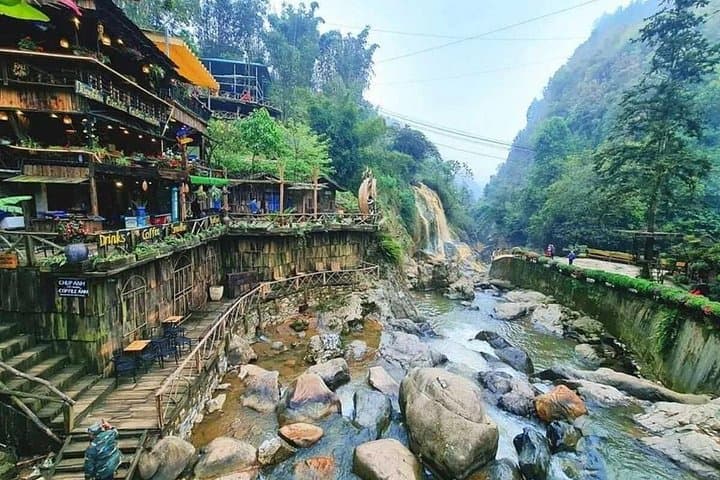
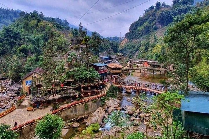
This two-day itinerary pairs cultural contact with easy-to-moderate trekking: downhill paths to Cat Cat, river-side trails to Y Linh Ho, and terrace circuits through Lao Chai and Ta Van. Expect stone footpaths, wooden stilt houses, weaving demonstrations, and the steady background of water and livestock. Local guides translate stories and show where terraces still depend on seasonal irrigation.
Practical guidance: pack layers—the valley shifts from sun to mist within an hour. Wear grippy shoes for wet stone and bring small change for stall purchases and tips; many villages have minimal card access. The sleeper bus covers Hanoi–Sapa roundtrip, reducing transit stress but increasing total travel time to roughly 12 hours each way; arrive rested. Keep to marked trails to limit erosion and ask before photographing people.
This trip balances gentle hiking, cultural immersion, and photographic viewpoints—an accessible two-day sample of northern Vietnam’s highland life.