THE ADVENTURE COLLECTIVE® · Independent discovery and booking for outdoor travel

Spend two days in the Hoang Lien range crossing terraced valleys, meeting hill‑tribe communities and ascending toward Fansipan—either by cable car or on foot. This short, well‑paced trip balances cultural stops with mountain scenery and practical logistics for first‑time visitors.
Spend two days in the Hoang Lien range crossing terraced valleys, meeting hill‑tribe communities and ascending toward Fansipan—either by cable car or on foot. This short, well‑paced trip balances cultural stops with mountain scenery and practical logistics for first‑time visitors.
Morning mist parts over terraced rice, and the town of Sapa wakes in a wash of green and damp stone. You begin with narrow streets ringing with the calls of market vendors, then climb toward the Hoang Lien Son massif where Fansipan, the highest point in Indochina, looms with granite ribs and cloud-wreathed ridgelines. The cable car rises like a patient rope, pulling you over emerald valleys that dare you to look down.
Verified experiences and guided adventures in the surrounding area.
Morning mist parts over terraced rice, and the town of Sapa wakes in a wash of green and damp stone. You begin with narrow streets ringing with the calls of market vendors, then climb toward the Hoang Lien Son massif where Fansipan, the highest point in Indochina, looms with granite ribs and cloud-wreathed ridgelines. The cable car rises like a patient rope, pulling you over emerald valleys that dare you to look down.
Sapa’s story is equal parts French hill station and centuries-old upland culture. The Hoang Lien range formed along tectonic uplift, leaving steep terraces etched by Hmong and Dao communities whose woven textiles and homestay hospitality define the area’s living culture. Geologically, Fansipan’s granite and metamorphic ridges create abrupt relief—short approaches with steep grade changes rather than long alpine marches.
Expect a mix of easy valley walks and a steeper summit approach if you opt to hike rather than ride the cable car. Weather shifts fast: fog can turn views to silver and wind will bite at exposed ridgelines. Local guides offer context—routes through Muong Hoa valley, village visits in Ta Phin, and perspectives on rice‑terrace agriculture that are as much cultural landscape as farmland.
Practical guidance: pack layered rain gear, sturdy boots, and warm layers for the summit. Start early to avoid mid‑day crowds at the cable car and allow time to acclimatize to cooler, thinner air. Respect trails and community spaces: tipping guides and buying local crafts channels tourism benefits directly into the villages you’ll pass through.
moderate.
2 days (≈48 hours).
Moderate fitness — able to manage several hours of walking with short steep sections; no technical climbing required for cable‑car option.
Most travelers take a 5–6 hour shuttle or bus to Lao Cai and continue 30–45 minutes to Sapa; overnight trains to Lao Cai plus a short transfer are another option.
There are two ways up: the cable car provides easy access to near the summit with short stair sections, while the hiking route is steep and best for experienced trekkers with a full day and guide.
Guides aren’t mandatory for short walks but are recommended for cultural context, navigation on unmarked trails, and support for local communities.
Sapa has a mountain climate—cooler and wetter than lowland Vietnam; bring rain protection and warm layers year‑round as conditions change quickly.
Sapa was developed as a French hill station in the early 20th century; Fansipan has long been a landmark for local Hmong and Dao communities and is known as the 'Roof of Indochina.'
Rising visitor numbers strain trails and village resources—stick to paths, avoid single‑use plastics, and support community‑run homestays and local guide services.
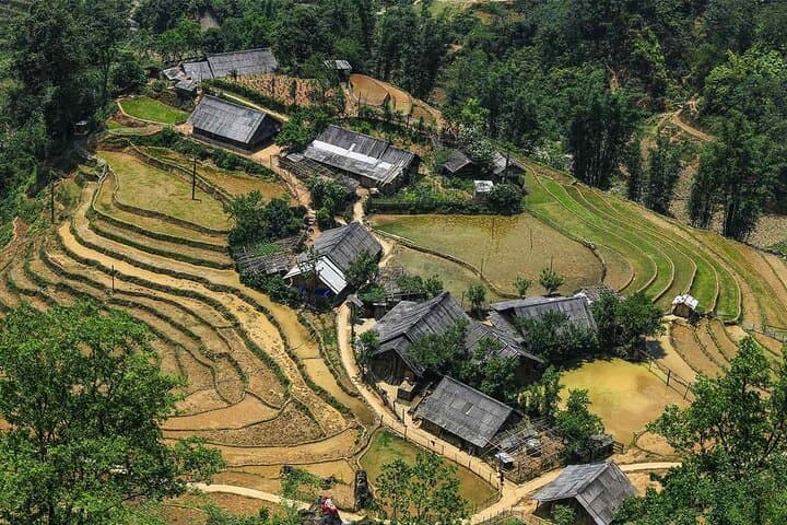
Morning mist parts over terraced rice, and the town of Sapa wakes in a wash of green and damp stone. You begin with narrow streets ringing with the calls of market vendors, then climb toward the Hoang Lien Son massif where Fansipan, the highest point in Indochina, looms with granite ribs and cloud-wreathed ridgelines. The cable car rises like a patient rope, pulling you over emerald valleys that dare you to look down.
Morning mist parts over terraced rice, and the town of Sapa wakes in a wash of green and damp stone. You begin with narrow streets ringing with the calls of market vendors, then climb toward the Hoang Lien Son massif where Fansipan, the highest point in Indochina, looms with granite ribs and cloud-wreathed ridgelines. The cable car rises like a patient rope, pulling you over emerald valleys that dare you to look down.
Sapa’s story is equal parts French hill station and centuries-old upland culture. The Hoang Lien range formed along tectonic uplift, leaving steep terraces etched by Hmong and Dao communities whose woven textiles and homestay hospitality define the area’s living culture. Geologically, Fansipan’s granite and metamorphic ridges create abrupt relief—short approaches with steep grade changes rather than long alpine marches.
Expect a mix of easy valley walks and a steeper summit approach if you opt to hike rather than ride the cable car. Weather shifts fast: fog can turn views to silver and wind will bite at exposed ridgelines. Local guides offer context—routes through Muong Hoa valley, village visits in Ta Phin, and perspectives on rice‑terrace agriculture that are as much cultural landscape as farmland.
Practical guidance: pack layered rain gear, sturdy boots, and warm layers for the summit. Start early to avoid mid‑day crowds at the cable car and allow time to acclimatize to cooler, thinner air. Respect trails and community spaces: tipping guides and buying local crafts channels tourism benefits directly into the villages you’ll pass through.