THE ADVENTURE COLLECTIVE® · Independent discovery and booking for outdoor travel

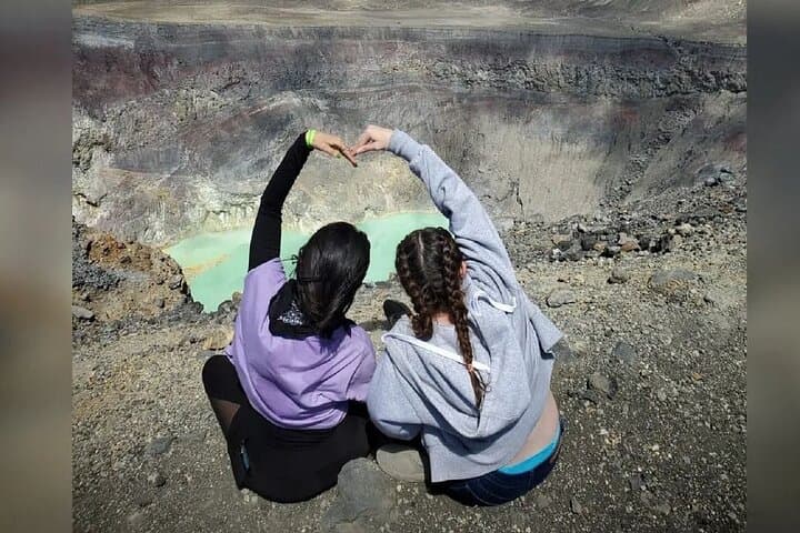
Traverse volcanic switchbacks up Santa Ana (Ilamatepec) then descend to the thermal blue of Lake Coatepeque on a private day tour. Expect steep volcanic trails, crater views, and calm lake waters ideal for paddling or a ferry to the island.
Traverse volcanic switchbacks up Santa Ana (Ilamatepec) then descend to the thermal blue of Lake Coatepeque on a private day tour. Expect steep volcanic trails, crater views, and calm lake waters ideal for paddling or a ferry to the island.
Morning light strips across the volcanic rim as the van climbs toward Ilamatepec, known to most as Santa Ana. By the time the trailhead appears, the crater’s steep lip has already drawn a low cloud up and over its edge; the air smells of tepezquite and wet earth. Hikers step onto packed volcanic scree and forested trail, trading the city’s heat for cool, thin air as the route gains roughly 500–650 meters to the crater rim at 2,384 m.
Verified experiences and guided adventures in the surrounding area.
Operated by MAURE TOURS · Santa Ana, Santa Ana Department
Morning light strips across the volcanic rim as the van climbs toward Ilamatepec, known to most as Santa Ana. By the time the trailhead appears, the crater’s steep lip has already drawn a low cloud up and over its edge; the air smells of tepezquite and wet earth. Hikers step onto packed volcanic scree and forested trail, trading the city’s heat for cool, thin air as the route gains roughly 500–650 meters to the crater rim at 2,384 m.
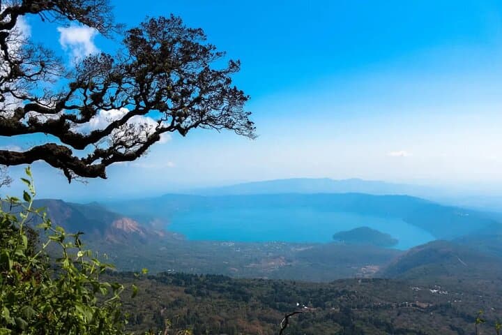
Santa Ana’s cone is a young, stratified volcano built of layers of ash and hardened lava; its last significant eruption in 2005 re-shaped fumarolic vents and reminded locals of the mountain’s power. A short drive later, Lake Coatepeque spreads like a deep blue caldera, its thermal pockets hinting at the subterranean work that made it. The lake has long been a local recreation hub—fishing, canoeing, and a small ferry to an island that’s worth a quick detour.
Expect a mixed day: a 4–6 hour outing to the crater including steep stair sections and loose volcanic rock, then 2–3 hours by the lake for photos, a swim or a boat trip. Guides commonly provide bilingual commentary on regional history, indigenous place names and current conservation efforts. Practical notes: start early to avoid midday clouds and crowds, carry 2–3 liters of water, and wear grippy shoes for volcanic scree. Weather shifts fast—pack a light shell. For photographers and hikers alike, the contrast between the raw, wind-scoured summit and the placid thermal waters of Coatepeque makes this a compact, singular Salvadoran day trip.
moderate.
8 hours (full-day).
Moderate fitness recommended: you should be comfortable with a sustained 500–650 m elevation gain and uneven terrain for several hours.
Most private tours do not include national park entrance fees—confirm with the operator before booking so you can pay local admission or conservation fees on site.
While the tour claims vehicle accessibility, the crater trail includes steep, rocky sections and is not wheelchair-accessible; families should assess kids’ hiking experience before attempting the summit walk.
Santa Ana (Ilamatepec) reaches 2,384 m; mild shortness of breath or fatigue is possible if you’re unacclimatized—take it steady and stay hydrated.
Yes; the lake supports swimming, kayaking and boat transfers to the island—plan these activities post-hike and bring swimwear and a towel.
The Santa Ana region has long been inhabited by Pipil peoples; volcanic landscapes and crater lakes factored into local settlement and agricultural patterns.
Visitors should stick to marked trails and avoid leaving waste at both the summit and the lake; local groups monitor erosion and water quality around Coatepeque.
MAURE TOURS operates guided outdoor trips and adventures with an emphasis on safety, stewardship, and memorable experiences.
Morning light strips across the volcanic rim as the van climbs toward Ilamatepec, known to most as Santa Ana. By the time the trailhead appears, the crater’s steep lip has already drawn a low cloud up and over its edge; the air smells of tepezquite and wet earth. Hikers step onto packed volcanic scree and forested trail, trading the city’s heat for cool, thin air as the route gains roughly 500–650 meters to the crater rim at 2,384 m.
Morning light strips across the volcanic rim as the van climbs toward Ilamatepec, known to most as Santa Ana. By the time the trailhead appears, the crater’s steep lip has already drawn a low cloud up and over its edge; the air smells of tepezquite and wet earth. Hikers step onto packed volcanic scree and forested trail, trading the city’s heat for cool, thin air as the route gains roughly 500–650 meters to the crater rim at 2,384 m.
Santa Ana’s cone is a young, stratified volcano built of layers of ash and hardened lava; its last significant eruption in 2005 re-shaped fumarolic vents and reminded locals of the mountain’s power. A short drive later, Lake Coatepeque spreads like a deep blue caldera, its thermal pockets hinting at the subterranean work that made it. The lake has long been a local recreation hub—fishing, canoeing, and a small ferry to an island that’s worth a quick detour.
Expect a mixed day: a 4–6 hour outing to the crater including steep stair sections and loose volcanic rock, then 2–3 hours by the lake for photos, a swim or a boat trip. Guides commonly provide bilingual commentary on regional history, indigenous place names and current conservation efforts. Practical notes: start early to avoid midday clouds and crowds, carry 2–3 liters of water, and wear grippy shoes for volcanic scree. Weather shifts fast—pack a light shell. For photographers and hikers alike, the contrast between the raw, wind-scoured summit and the placid thermal waters of Coatepeque makes this a compact, singular Salvadoran day trip.