THE ADVENTURE COLLECTIVE® · Independent discovery and booking for outdoor travel

Trek from Kalipur Beach through subtropical forest to reach Saddle Peak, the Andaman Islands' 732 m high point. This guided, permit-required route is an 8 km round-trip with freshwater streams, village crossings and panoramic island views.
Trek from Kalipur Beach through subtropical forest to reach Saddle Peak, the Andaman Islands' 732 m high point. This guided, permit-required route is an 8 km round-trip with freshwater streams, village crossings and panoramic island views.
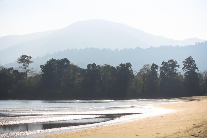
Morning light breaks over Kalipur Beach and Saddle Peak rises like a dark shoulder on the horizon. Trekkers meet at the sand, watch the sunrise silhouette the ridge, and set off along a narrow coastal strip before the trail turns inward and the forest closes in.
Verified experiences and guided adventures in the surrounding area.
Operated by Trodly · Diglipur, Andaman and Nicobar Islands
Morning light breaks over Kalipur Beach and Saddle Peak rises like a dark shoulder on the horizon. Trekkers meet at the sand, watch the sunrise silhouette the ridge, and set off along a narrow coastal strip before the trail turns inward and the forest closes in.
The route climbs to 732 m, the highest point in the Andaman range, passing subtropical canopy, freshwater streams and a small village within the national park. Geologically the hills are ancient granitic outcrops; erosion has carved steep gullies and craggy viewpoints that offer clear views of the surrounding archipelago and offshore islets. The area combines tribal history and colonial-era land use—fisher communities on the coast, protected forest inland—so visitors should respect local spaces and park rules. Marine life flourishes around the coast and the park protects both terrestrial and coastal ecosystems.
Practical guidance is straightforward: the marked route covers roughly 8 km round-trip with a net ascent to the summit and about 6–8 hours on the itinerary. A permit is required; guided treks include park entry and a local guide. Expect humid, sticky conditions, intermittently slippery roots and stream crossings where water dares your boots. Carry at least 2–3 liters of water, sun protection, and light layers; start early to avoid midday heat and to catch the best visibility.
On-trail facilities are minimal—there are rest huts and clear signposting, but no refill stations. Leave no trace, follow guide instructions, and plan for a steady pace: the terrain rewards patience with broad island panoramas from the summit.
moderate.
6–8 hours.
Suitable for people in reasonable physical condition who can handle sustained walking, some steep sections and humid conditions.
Yes—Saddle Peak lies within a protected area; permits are required and typically handled by guides or operators included with guided bookings.
The marked route is about 8 km round-trip with a summit at 732 m; allow 6–8 hours total at a steady pace with rest stops.
Dry months from November to April offer the most reliable weather and visibility; monsoon months bring heavy rain and slippery trails.
Facilities are minimal—there are a few rest huts and signage, but no reliable water refills or toilets at the summit, so come prepared.
The area around Diglipur has long been a coastal fishing landscape; the national park protects both marine and terrestrial habitats shaped by traditional use and colonial-era mapping.
Saddle Peak National Park balances visitor access with habitat protection—stay on marked trails, carry out waste, and avoid disturbing wildlife to reduce impact.
Trodly operates guided outdoor trips and adventures with an emphasis on safety, stewardship, and memorable experiences.
Morning light breaks over Kalipur Beach and Saddle Peak rises like a dark shoulder on the horizon. Trekkers meet at the sand, watch the sunrise silhouette the ridge, and set off along a narrow coastal strip before the trail turns inward and the forest closes in.
Morning light breaks over Kalipur Beach and Saddle Peak rises like a dark shoulder on the horizon. Trekkers meet at the sand, watch the sunrise silhouette the ridge, and set off along a narrow coastal strip before the trail turns inward and the forest closes in.
The route climbs to 732 m, the highest point in the Andaman range, passing subtropical canopy, freshwater streams and a small village within the national park. Geologically the hills are ancient granitic outcrops; erosion has carved steep gullies and craggy viewpoints that offer clear views of the surrounding archipelago and offshore islets. The area combines tribal history and colonial-era land use—fisher communities on the coast, protected forest inland—so visitors should respect local spaces and park rules. Marine life flourishes around the coast and the park protects both terrestrial and coastal ecosystems.
Practical guidance is straightforward: the marked route covers roughly 8 km round-trip with a net ascent to the summit and about 6–8 hours on the itinerary. A permit is required; guided treks include park entry and a local guide. Expect humid, sticky conditions, intermittently slippery roots and stream crossings where water dares your boots. Carry at least 2–3 liters of water, sun protection, and light layers; start early to avoid midday heat and to catch the best visibility.
On-trail facilities are minimal—there are rest huts and clear signposting, but no refill stations. Leave no trace, follow guide instructions, and plan for a steady pace: the terrain rewards patience with broad island panoramas from the summit.