THE ADVENTURE COLLECTIVE® · Independent discovery and booking for outdoor travel

A demanding half-day circuit into Terceira’s interior, Rocha do Chambre climbs to roughly 2,600 ft through Japanese cedar plantations and raw volcanic highlands. This guide outlines what to expect on the 9.3 km loop and how to prepare for steep, exposed terrain and sudden weather changes.
A demanding half-day circuit into Terceira’s interior, Rocha do Chambre climbs to roughly 2,600 ft through Japanese cedar plantations and raw volcanic highlands. This guide outlines what to expect on the 9.3 km loop and how to prepare for steep, exposed terrain and sudden weather changes.
Wind slices across the open ridges of Terceira as hikers crest toward Rocha do Chambre, where cedar trunks crowd the path and sudden vistas drop to the Atlantic. The trail threads interior highlands, climbing to about 2,600 feet and revealing layered basalt slopes shaped by ancient eruptions.
Verified experiences and guided adventures in the surrounding area.
Operated by Angratravel Tours · Angra do Heroísmo, Azores
Wind slices across the open ridges of Terceira as hikers crest toward Rocha do Chambre, where cedar trunks crowd the path and sudden vistas drop to the Atlantic. The trail threads interior highlands, climbing to about 2,600 feet and revealing layered basalt slopes shaped by ancient eruptions.
Terceira’s land is volcanic: lava flows and cinder cones from repeated eruptions built the island over millennia. Settled by Portuguese in the 15th century, the interior later received Japanese cedar plantations that now give the route its distinctive tall, straight trunks. Local farming and forest management have left a patchwork of native laurisilva pockets and introduced stands that frame the viewpoints.
Expect a raw, exposed circuit of roughly 9.3 kilometers with steep pitches, rocky footing and sections of soft forest duff. The route is circular and can be done as a half-day outing in firm weather; guide-led groups typically allow four hours including stops. Bring waterproof layers—fog and sudden rain are common—and sturdy boots for scree and rooty sections. Hydrate before exposed stretches and carry snacks with electrolytes; there are no services on the route. Navigation can be straightforward on marked tracks but require attention where paths cross plantations.
Best times are late spring through early autumn for longer daylight and fewer storms; mornings offer clearer air for panoramas. Leave no trace: stick to paths, pack out trash, and avoid disturbing nesting birds. With preparation, Rocha do Chambre rewards effort with raw, highland views that feel like walking on the island's geologic story.
challenging.
2–4 hours.
Requires a high level of cardiovascular fitness and comfort on steep, uneven terrain.
The circuit is about 9.3 km and guide-led outings typically allocate roughly 2.5–4 hours depending on pace and stops.
A guide is not strictly required but recommended for visitors unfamiliar with Azorean highland tracks or when weather is variable.
This is a challenging route with steep sections—participants should be in good cardiovascular shape and comfortable on uneven ground.
There are no services on the route; carry water and plan restroom use before starting.
Rocha do Chambre sits on volcanic highlands formed by past eruptions; Portuguese settlers introduced forestry and agriculture in the 15th century, shaping the current mosaic of native and planted woods.
The interior contains fragile native vegetation; stay on trails, avoid trampling regrowth, and pack out all waste to limit erosion and disturbance.
Angratravel Tours operates guided outdoor trips and adventures with an emphasis on safety, stewardship, and memorable experiences.
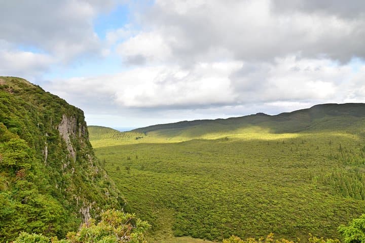
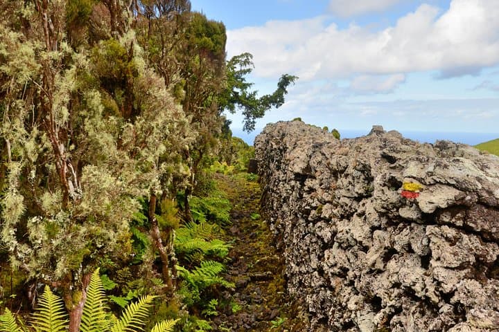
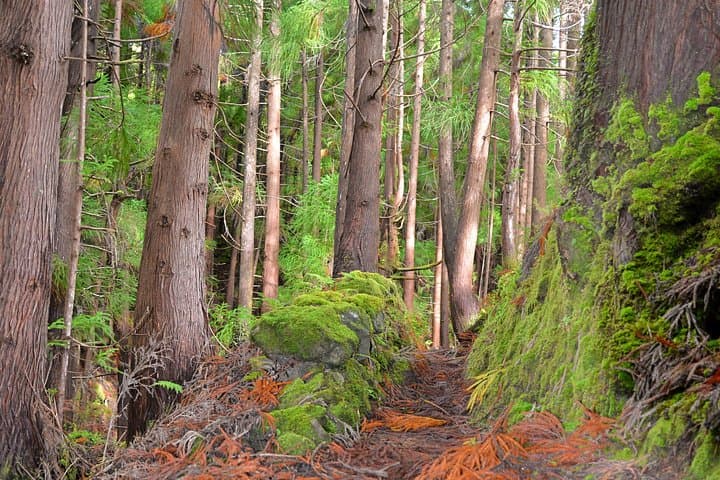
Wind slices across the open ridges of Terceira as hikers crest toward Rocha do Chambre, where cedar trunks crowd the path and sudden vistas drop to the Atlantic. The trail threads interior highlands, climbing to about 2,600 feet and revealing layered basalt slopes shaped by ancient eruptions.
Wind slices across the open ridges of Terceira as hikers crest toward Rocha do Chambre, where cedar trunks crowd the path and sudden vistas drop to the Atlantic. The trail threads interior highlands, climbing to about 2,600 feet and revealing layered basalt slopes shaped by ancient eruptions.
Terceira’s land is volcanic: lava flows and cinder cones from repeated eruptions built the island over millennia. Settled by Portuguese in the 15th century, the interior later received Japanese cedar plantations that now give the route its distinctive tall, straight trunks. Local farming and forest management have left a patchwork of native laurisilva pockets and introduced stands that frame the viewpoints.
Expect a raw, exposed circuit of roughly 9.3 kilometers with steep pitches, rocky footing and sections of soft forest duff. The route is circular and can be done as a half-day outing in firm weather; guide-led groups typically allow four hours including stops. Bring waterproof layers—fog and sudden rain are common—and sturdy boots for scree and rooty sections. Hydrate before exposed stretches and carry snacks with electrolytes; there are no services on the route. Navigation can be straightforward on marked tracks but require attention where paths cross plantations.
Best times are late spring through early autumn for longer daylight and fewer storms; mornings offer clearer air for panoramas. Leave no trace: stick to paths, pack out trash, and avoid disturbing nesting birds. With preparation, Rocha do Chambre rewards effort with raw, highland views that feel like walking on the island's geologic story.