THE ADVENTURE COLLECTIVE® · Independent discovery and booking for outdoor travel

A full-day guided hike from Matale to Riverston explores grassy plateaus, shola forest and a sharp 300 m cliff known as Mini World’s End. Expect misty ridgelines, panoramic valley views and a moderate 6–8 km outing with significant elevation change.
A full-day guided hike from Matale to Riverston explores grassy plateaus, shola forest and a sharp 300 m cliff known as Mini World’s End. Expect misty ridgelines, panoramic valley views and a moderate 6–8 km outing with significant elevation change.
You set off at dawn from Matale and the road narrows as fog presses into the windscreen. By the time you reach the Riverston telecommunications tower the world has quieted; the trail opens onto grassland and the Knuckles ridgeline looms like a folded map. The first stretch climbs through shola forest, then gives way to Pittawala Paththana’s open pahasa—wide, tussock-studded plains where mist and sun trade places across the slope.
Verified experiences and guided adventures in the surrounding area.
Operated by Lakpura LLC · Riverston, Central Province
You set off at dawn from Matale and the road narrows as fog presses into the windscreen. By the time you reach the Riverston telecommunications tower the world has quieted; the trail opens onto grassland and the Knuckles ridgeline looms like a folded map. The first stretch climbs through shola forest, then gives way to Pittawala Paththana’s open pahasa—wide, tussock-studded plains where mist and sun trade places across the slope.
Riverston sits on the eastern edge of the Knuckles Range, a geologically young uplift of Precambrian rock fractured into ridges and valleys. The highland plateau feeds several rivers and the area carries cultural traces of hill-country farming: terraced fields and small villages visible on the descent. At Mini World’s End a sheer 300 m drop frames Thelgamuwa Valley and the distant Knuckles peaks; on clear days the panorama extends across terraced farmland to lowland plains.
Expect a mixed trail: packed earth, occasional rock steps, boggy patches on the plateau and exposed ridgelines. Typical day hikes here are roughly 6–8 km round trip with 350–600 m of ascent depending on route choice; the operator schedules a full 9-hour outing including lunch and transport.
Practical guidance: start early to avoid afternoon cloud, carry waterproof layers and 2–3 liters of water, and wear sturdy boots with ankle support. Weather shifts fast—rain and wind can turn the plateau cold—so pack a warm mid-layer. Follow your guide, respect fragile grasslands, and leave no trace to protect this biodiverse highland.
moderate.
9 hours.
Moderate — comfortable with sustained climbs and uneven terrain for several hours
The guided outing runs about 9 hours round trip; typical hiking distance is 6–8 km with roughly 350–600 m of ascent depending on the route.
The route is rated moderate; fit beginners who can handle uneven ground and steady climbs can participate, but it's not recommended for those with serious cardiovascular or spinal conditions.
Highland weather is changeable—clear mornings can become misty or rainy by afternoon. Temperatures are cooler than lowlands; bring layers and rain protection.
This excursion is guided and includes a local guide; check with the operator about park rules, but guided hikes are standard in this conserved highland zone.
Riverston and the Knuckles Range have long supported upland agriculture and small-scale settlements; the ridges were important local landmarks for trade routes between hill country villages.
The Knuckles Conservation Forest protects highland biodiversity and fragile grasslands; stay on trails to avoid trampling sensitive peat soils and native grasses.
Lakpura LLC operates guided outdoor trips and adventures with an emphasis on safety, stewardship, and memorable experiences.
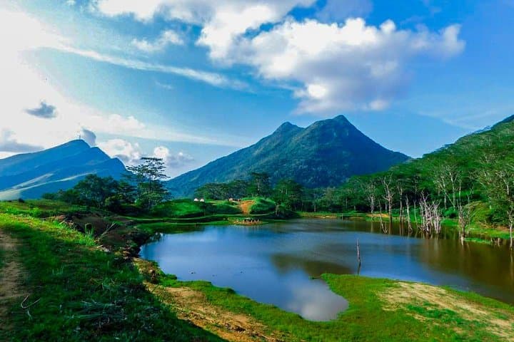


You set off at dawn from Matale and the road narrows as fog presses into the windscreen. By the time you reach the Riverston telecommunications tower the world has quieted; the trail opens onto grassland and the Knuckles ridgeline looms like a folded map. The first stretch climbs through shola forest, then gives way to Pittawala Paththana’s open pahasa—wide, tussock-studded plains where mist and sun trade places across the slope.
You set off at dawn from Matale and the road narrows as fog presses into the windscreen. By the time you reach the Riverston telecommunications tower the world has quieted; the trail opens onto grassland and the Knuckles ridgeline looms like a folded map. The first stretch climbs through shola forest, then gives way to Pittawala Paththana’s open pahasa—wide, tussock-studded plains where mist and sun trade places across the slope.
Riverston sits on the eastern edge of the Knuckles Range, a geologically young uplift of Precambrian rock fractured into ridges and valleys. The highland plateau feeds several rivers and the area carries cultural traces of hill-country farming: terraced fields and small villages visible on the descent. At Mini World’s End a sheer 300 m drop frames Thelgamuwa Valley and the distant Knuckles peaks; on clear days the panorama extends across terraced farmland to lowland plains.
Expect a mixed trail: packed earth, occasional rock steps, boggy patches on the plateau and exposed ridgelines. Typical day hikes here are roughly 6–8 km round trip with 350–600 m of ascent depending on route choice; the operator schedules a full 9-hour outing including lunch and transport.
Practical guidance: start early to avoid afternoon cloud, carry waterproof layers and 2–3 liters of water, and wear sturdy boots with ankle support. Weather shifts fast—rain and wind can turn the plateau cold—so pack a warm mid-layer. Follow your guide, respect fragile grasslands, and leave no trace to protect this biodiverse highland.