THE ADVENTURE COLLECTIVE® · Independent discovery and booking for outdoor travel

Float above Maine’s mosaic of lakes and ridgelines on a private 30-minute seaplane tour. Spot moose, eagles, and glacially carved lakes while learning about the region’s logging and guiding history from a pilot-guide.
Float above Maine’s mosaic of lakes and ridgelines on a private 30-minute seaplane tour. Spot moose, eagles, and glacially carved lakes while learning about the region’s logging and guiding history from a pilot-guide.
You lift from a glassy inlet and the world rearranges itself: lakes spread like scattered mirrors, ridgelines cut clean against the sky, and islands shrink to thumbnail dots. The seaplane hums under you while shorelines and marshes open up—moose pockets dark against sedge, rivers threading toward distant dams. A private 30-minute flight over the Rangeley Lakes Region gives a compact, aerial view of this glacial-cut landscape.
Verified experiences and guided adventures in the surrounding area.
You lift from a glassy inlet and the world rearranges itself: lakes spread like scattered mirrors, ridgelines cut clean against the sky, and islands shrink to thumbnail dots. The seaplane hums under you while shorelines and marshes open up—moose pockets dark against sedge, rivers threading toward distant dams. A private 30-minute flight over the Rangeley Lakes Region gives a compact, aerial view of this glacial-cut landscape.
The Rangeley region formed where glaciers gouged basins into granite and schist, leaving a landscape of interconnected lakes and steep hills created by glacial scouring and post‑glacial rebound. Euro-American logging and recreational hunting shaped local culture from the 19th century onward; small town centers like Rangeley served as hubs for anglers, guides, and summer visitors. From above you see both the scars of human use and long stretches of intact forest—spruce and fir pushing up against water.
Practically, expect low-level passes over Rangeley Lake, Mooselookmeguntic, and nearby ponds with ample photo windows. Wildlife—especially moose—are often visible at dawn and dusk when they feed along shorelines; eagles ride thermals above open water. The flight is private, so pilots can tailor routing to weather and sightings; however, visibility and wind determine what you’ll see.
Bring a camera with a fast shutter and a polarizer, dress in layers against wind chill at altitude, and pick a morning slot for calmer air and better wildlife activity. Listen to the pilot’s safety briefing, keep gear stowed during takeoff and landing on water, and relax—the lakes below are doing the daring work.
easy.
30 minutes.
Minimal fitness required; passengers should be able to get into and out of a floatplane and follow safety instructions.
This is a 30-minute private seaplane flight that typically covers multiple lakes and shorelines in the Rangeley area.
Moose sightings are common on these tours, especially near marshy shorelines and river inlets at dawn or dusk, but wildlife can’t be guaranteed.
Most ages can fly, but passengers should be able to board a floatplane and follow safety instructions; check with the operator about mobility concerns.
Flights are weather-dependent; the operator may reschedule or cancel for safety if visibility, wind, or precipitation make low-altitude flying unsafe.
The Rangeley region grew as a 19th-century logging and guiding center; sporting camps and guideboats shaped its recreational economy and conservation ethos.
The area balances recreation with forest management and brook trout habitat protection—choose operators who follow noise and wildlife-distance practices to minimize disturbance.
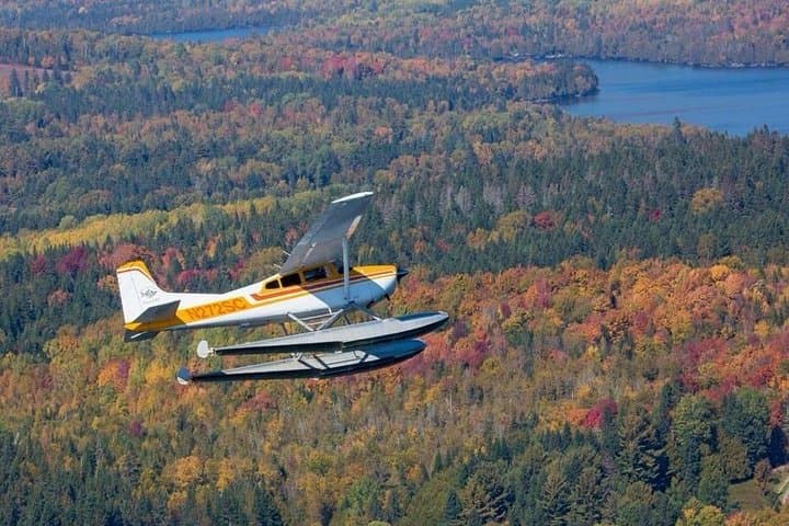
You lift from a glassy inlet and the world rearranges itself: lakes spread like scattered mirrors, ridgelines cut clean against the sky, and islands shrink to thumbnail dots. The seaplane hums under you while shorelines and marshes open up—moose pockets dark against sedge, rivers threading toward distant dams. A private 30-minute flight over the Rangeley Lakes Region gives a compact, aerial view of this glacial-cut landscape.
You lift from a glassy inlet and the world rearranges itself: lakes spread like scattered mirrors, ridgelines cut clean against the sky, and islands shrink to thumbnail dots. The seaplane hums under you while shorelines and marshes open up—moose pockets dark against sedge, rivers threading toward distant dams. A private 30-minute flight over the Rangeley Lakes Region gives a compact, aerial view of this glacial-cut landscape.
The Rangeley region formed where glaciers gouged basins into granite and schist, leaving a landscape of interconnected lakes and steep hills created by glacial scouring and post‑glacial rebound. Euro-American logging and recreational hunting shaped local culture from the 19th century onward; small town centers like Rangeley served as hubs for anglers, guides, and summer visitors. From above you see both the scars of human use and long stretches of intact forest—spruce and fir pushing up against water.
Practically, expect low-level passes over Rangeley Lake, Mooselookmeguntic, and nearby ponds with ample photo windows. Wildlife—especially moose—are often visible at dawn and dusk when they feed along shorelines; eagles ride thermals above open water. The flight is private, so pilots can tailor routing to weather and sightings; however, visibility and wind determine what you’ll see.
Bring a camera with a fast shutter and a polarizer, dress in layers against wind chill at altitude, and pick a morning slot for calmer air and better wildlife activity. Listen to the pilot’s safety briefing, keep gear stowed during takeoff and landing on water, and relax—the lakes below are doing the daring work.