THE ADVENTURE COLLECTIVE® · Independent discovery and booking for outdoor travel

Traverse wartime tracks to reach Pu To Co Peak for sweeping views of the Muong Thanh Valley and a living lesson in the 1954 Dien Bien Phu campaign. This full-day trek blends history, highland scenery, and homestay hospitality.
Traverse wartime tracks to reach Pu To Co Peak for sweeping views of the Muong Thanh Valley and a living lesson in the 1954 Dien Bien Phu campaign. This full-day trek blends history, highland scenery, and homestay hospitality.
A low cloud peels back from the Muong Thanh Valley as your jeep threads a mountain road and drops you at a homestay before first light. The trailhead smells of wet earth and wood smoke; path markers follow faint wartime tracks that once linked observation posts and supply lines.
Verified experiences and guided adventures in the surrounding area.
Operated by Authentic Travel VIETNAM · Dien Bien Phu, Dien Bien Province
A low cloud peels back from the Muong Thanh Valley as your jeep threads a mountain road and drops you at a homestay before first light. The trailhead smells of wet earth and wood smoke; path markers follow faint wartime tracks that once linked observation posts and supply lines.
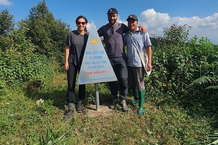
This one-day trek follows routes tied to the 1954 Dien Bien Phu campaign—Muong Phang’s bunkers and the observation post on Pu To Co (≈1,700 m) are tangible links to a decisive moment in modern Vietnamese history. Geologically the route climbs a folded highland ridge typical of Northwest Vietnam: steep, forested slopes underlain by metamorphic rock and pockets of thin soil that can turn sticky in rain. Local Thai and Hmong villages pepper the approach; Ban Kha’s homestay culture offers simple rice-and-vegetable meals and a chance to meet upland farmers.
Expect about 3 hours of steady ascent and a total outing near 10 hours including transfers. Trails switch between narrow singletrack, occasional stone steps and open ridgeline with exposed viewpoints. Weather shifts fast—mornings can be clear, afternoons fogged or rainy during the monsoon.
Practical tips: start early, carry 2–3 liters of water, layered clothing and grippy hiking shoes. A local English- or Vietnamese-speaking guide and jeep transfer are typically included; the route is physically moderate but uneven underfoot. Respect cultural sites and follow leave-no-trace practices—these slopes recover slowly from erosion. Reach the summit for a commanding view of the valley where tactical decisions once played out; the climb returns you to village life and a hot, home-cooked lunch.
moderate.
10 hours.
Moderate cardiovascular fitness; able to hike uphill 3 hours on uneven terrain and descend 5.5 km without assistance.
The climb is moderate: about 3 hours up on uneven trail with roughly 700–1,000 m of elevation gain depending on start point. Steady fitness and good footwear are recommended.
No special permits are usually required for this organized day tour; entry to Muong Phang Historical Site may have a small fee included by the operator.
Pu To Co is around 1,700 m—most visitors do not experience severe altitude sickness, but go slowly, hydrate, and notify guides if you feel unwell.
According to the tour details, jeep transfer, bottled water, breakfast, lunch and an English/Vietnamese guide are included; confirm pickup point when booking.
The Muong Phang area and Pu To Co were strategic observation and command points during the 1954 Battle of Dien Bien Phu, influencing tactical decisions that ended French colonial control in Indochina.
Trails fragile from heavy rains—stick to marked paths, avoid disturbing relics, and support homestays to keep tourism benefits local and sustainable.
Authentic Travel VIETNAM operates guided outdoor trips and adventures with an emphasis on safety, stewardship, and memorable experiences.
A low cloud peels back from the Muong Thanh Valley as your jeep threads a mountain road and drops you at a homestay before first light. The trailhead smells of wet earth and wood smoke; path markers follow faint wartime tracks that once linked observation posts and supply lines.
A low cloud peels back from the Muong Thanh Valley as your jeep threads a mountain road and drops you at a homestay before first light. The trailhead smells of wet earth and wood smoke; path markers follow faint wartime tracks that once linked observation posts and supply lines.
This one-day trek follows routes tied to the 1954 Dien Bien Phu campaign—Muong Phang’s bunkers and the observation post on Pu To Co (≈1,700 m) are tangible links to a decisive moment in modern Vietnamese history. Geologically the route climbs a folded highland ridge typical of Northwest Vietnam: steep, forested slopes underlain by metamorphic rock and pockets of thin soil that can turn sticky in rain. Local Thai and Hmong villages pepper the approach; Ban Kha’s homestay culture offers simple rice-and-vegetable meals and a chance to meet upland farmers.
Expect about 3 hours of steady ascent and a total outing near 10 hours including transfers. Trails switch between narrow singletrack, occasional stone steps and open ridgeline with exposed viewpoints. Weather shifts fast—mornings can be clear, afternoons fogged or rainy during the monsoon.
Practical tips: start early, carry 2–3 liters of water, layered clothing and grippy hiking shoes. A local English- or Vietnamese-speaking guide and jeep transfer are typically included; the route is physically moderate but uneven underfoot. Respect cultural sites and follow leave-no-trace practices—these slopes recover slowly from erosion. Reach the summit for a commanding view of the valley where tactical decisions once played out; the climb returns you to village life and a hot, home-cooked lunch.