THE ADVENTURE COLLECTIVE® · Independent discovery and booking for outdoor travel

Follow the war trails to Pu To Co Peak and stand where commanders once surveyed the Muong Thanh Valley. This full-day trek blends a 1954 battlefield’s history with highland scenery and village culture.
Follow the war trails to Pu To Co Peak and stand where commanders once surveyed the Muong Thanh Valley. This full-day trek blends a 1954 battlefield’s history with highland scenery and village culture.
Dawn breaks over the Muong Thanh Valley and the trail breathes cool, pine-scented air into your lungs. You follow a worn war trail, the path climbing through secondary forest and terraced fields, the earth underfoot alternating between packed red soil and loose stone. At certain bends the valley opens, revealing the low plain where the 1954 campaign unfolded; from higher up, you can already feel the slope tugging at your legs as the summit approaches.
Verified experiences and guided adventures in the surrounding area.
Operated by Authentic HALONG · Dien Bien Phu, Dien Bien Province
Dawn breaks over the Muong Thanh Valley and the trail breathes cool, pine-scented air into your lungs. You follow a worn war trail, the path climbing through secondary forest and terraced fields, the earth underfoot alternating between packed red soil and loose stone. At certain bends the valley opens, revealing the low plain where the 1954 campaign unfolded; from higher up, you can already feel the slope tugging at your legs as the summit approaches.
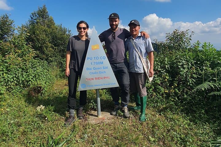
Pu To Co sits at roughly 1,700 meters and was an observation post during the decisive Battle of Dien Bien Phu. Geologically the ridge is part of the northwestern highlands — folded sedimentary layers uplifted by tectonic forces and eroded into steep, bench-like slopes. Culturally, this area is shaped by Tai and Hmong communities whose hill gardens and stilt houses line the approach; local guides often weave military history with village life and foodways.
Expect about 3 hours of steady ascent on singletrack and forest tracks, then a panoramic 360° outlook over Muong Thanh at the summit. The descent is steeper in places and runs around 5.5 km to the homestay in Ban Kha.
Practical guidance: start early to avoid midday heat and to catch clearer valley views; carry 2–3 liters of water, a rain shell (weather turns quickly), and sturdy boots with good traction. Respect battlefield markers and village spaces, pack out waste, and allow extra time for photo stops and historical interpretation along the route.
moderate.
9 hours.
Moderate fitness; able to sustain a steady 3-hour uphill hike and handle uneven, sometimes steep descent.
The ascent takes about 3 hours on steady singletrack with intermittent steep sections; it’s rated moderate and accessible to most active walkers.
Yes — this full-day private tour includes an English-Vietnamese speaking guide and jeep or motorbike transfer from Dien Bien Phu.
No special permits are typically required for this route, but always follow local guide instructions when visiting historical sites and private land.
At ~1,700 m symptoms are uncommon, but take it steady, stay hydrated, and notify the guide if you feel dizzy or breathless.
Pu To Co and Muong Phang were strategic observation and command areas during the 1954 Battle of Dien Bien Phu, where Vietnamese forces encircled and defeated French positions.
The montane forests are fragile — stick to trails, avoid disturbing wildlife, and take all trash out; supporting local homestays helps preserve cultural landscapes.
Authentic HALONG operates guided outdoor trips and adventures with an emphasis on safety, stewardship, and memorable experiences.

Dawn breaks over the Muong Thanh Valley and the trail breathes cool, pine-scented air into your lungs. You follow a worn war trail, the path climbing through secondary forest and terraced fields, the earth underfoot alternating between packed red soil and loose stone. At certain bends the valley opens, revealing the low plain where the 1954 campaign unfolded; from higher up, you can already feel the slope tugging at your legs as the summit approaches.
Dawn breaks over the Muong Thanh Valley and the trail breathes cool, pine-scented air into your lungs. You follow a worn war trail, the path climbing through secondary forest and terraced fields, the earth underfoot alternating between packed red soil and loose stone. At certain bends the valley opens, revealing the low plain where the 1954 campaign unfolded; from higher up, you can already feel the slope tugging at your legs as the summit approaches.
Pu To Co sits at roughly 1,700 meters and was an observation post during the decisive Battle of Dien Bien Phu. Geologically the ridge is part of the northwestern highlands — folded sedimentary layers uplifted by tectonic forces and eroded into steep, bench-like slopes. Culturally, this area is shaped by Tai and Hmong communities whose hill gardens and stilt houses line the approach; local guides often weave military history with village life and foodways.
Expect about 3 hours of steady ascent on singletrack and forest tracks, then a panoramic 360° outlook over Muong Thanh at the summit. The descent is steeper in places and runs around 5.5 km to the homestay in Ban Kha.
Practical guidance: start early to avoid midday heat and to catch clearer valley views; carry 2–3 liters of water, a rain shell (weather turns quickly), and sturdy boots with good traction. Respect battlefield markers and village spaces, pack out waste, and allow extra time for photo stops and historical interpretation along the route.