THE ADVENTURE COLLECTIVE® · Independent discovery and booking for outdoor travel

Walk the exposed eastern lip of Madeira along basalt ridges and rare endemic flora. This full-day coastal hike offers wide ocean views, seabird colonies and a landscape unlike the island’s forested interior.
Walk the exposed eastern lip of Madeira along basalt ridges and rare endemic flora. This full-day coastal hike offers wide ocean views, seabird colonies and a landscape unlike the island’s forested interior.
A sharp wind meets you as you step onto the eastern lip of Madeira. Low, sculpted ridges fall away into the Atlantic and the path runs like a spine toward the tip, where waves chisel basalt cliffs and the horizon opens to the Ilhas Desertas and Porto Santo.
Verified experiences and guided adventures in the surrounding area.
Operated by Madeira Happy Tours · Caniçal, Madeira
A sharp wind meets you as you step onto the eastern lip of Madeira. Low, sculpted ridges fall away into the Atlantic and the path runs like a spine toward the tip, where waves chisel basalt cliffs and the horizon opens to the Ilhas Desertas and Porto Santo.
The headland takes its name from the caravel of João Gonçalves de Zarco, one of Madeira's early discoverers. Geologically the peninsula lays bare the island’s basaltic basement: lava flows and eroded sea cliffs expose raw volcanic rock rather than the laurisilva forests found inland. That exposure and a semi-arid microclimate mean few trees, but a high concentration of endemic plants—dozens of species unique to Madeira—cling to thin soils. The area is a protected Natura 2000 site and hosts large seabird colonies, including Cory’s Shearwater; from time to time the rare Mediterranean monk seal can be seen offshore.
Expect an exposed, stony route of roughly 8 km round-trip with about 100–200 m cumulative elevation gain: mostly rolling ridges and rocky track rather than steep climbs. The trail is well-marked but sun and wind are constant companions, so plan for full sun protection, sturdy footwear with good grip, and at least 1.5–2 liters of water per person. Start early to catch clearer views to the Desertas and Porto Santo and to avoid the strongest afternoon winds.
Respect signage: breeding seabirds and fragile endemic plants are easy to damage. The walk finishes near the small Casa do Sardinha outpost, a practical place to rest before retracing your steps back to the trailhead.
challenging.
6–7 hours.
Good aerobic fitness and stable footing for several hours; able to handle exposure, wind, and rocky terrain.
Typical itineraries take 6–7 hours round-trip for an approximate 8 km route with 100–200 m elevation gain; pace, stops, and weather affect total time.
Children with good stamina and experience on exposed trails can do it, but pets should be kept on leash to protect wildlife; the operator notes service animals are allowed.
Occasional sightings of the Mediterranean monk seal (locally called the Sea-wolf) and passing cetaceans occur, but they are not guaranteed—bring binoculars for the best chance.
No permit is required to hike the peninsula; guided walks add local interpretation and may improve wildlife spotting but the path is accessible independently.
Ponta de São Lourenço is named after the caravel of João Gonçalves de Zarco; its exposed geology differs from Madeira’s interior forests and reflects early volcanic foundations.
The peninsula is a protected Natura 2000 site with many endemic plants and breeding seabirds; stick to paths, avoid disturbing nests, and pack out all waste to minimize impact.
Madeira Happy Tours operates guided outdoor trips and adventures with an emphasis on safety, stewardship, and memorable experiences.


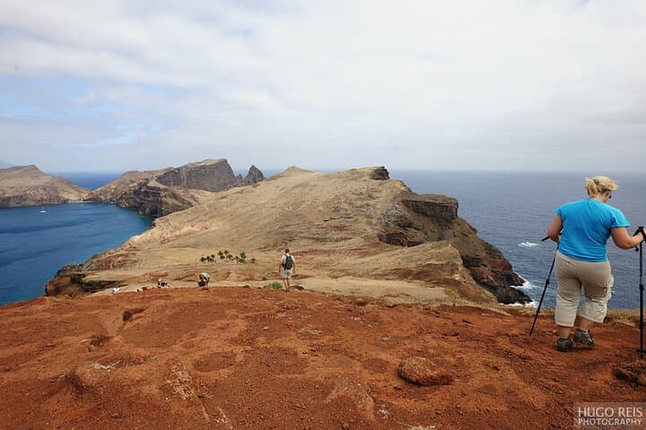
A sharp wind meets you as you step onto the eastern lip of Madeira. Low, sculpted ridges fall away into the Atlantic and the path runs like a spine toward the tip, where waves chisel basalt cliffs and the horizon opens to the Ilhas Desertas and Porto Santo.
A sharp wind meets you as you step onto the eastern lip of Madeira. Low, sculpted ridges fall away into the Atlantic and the path runs like a spine toward the tip, where waves chisel basalt cliffs and the horizon opens to the Ilhas Desertas and Porto Santo.
The headland takes its name from the caravel of João Gonçalves de Zarco, one of Madeira's early discoverers. Geologically the peninsula lays bare the island’s basaltic basement: lava flows and eroded sea cliffs expose raw volcanic rock rather than the laurisilva forests found inland. That exposure and a semi-arid microclimate mean few trees, but a high concentration of endemic plants—dozens of species unique to Madeira—cling to thin soils. The area is a protected Natura 2000 site and hosts large seabird colonies, including Cory’s Shearwater; from time to time the rare Mediterranean monk seal can be seen offshore.
Expect an exposed, stony route of roughly 8 km round-trip with about 100–200 m cumulative elevation gain: mostly rolling ridges and rocky track rather than steep climbs. The trail is well-marked but sun and wind are constant companions, so plan for full sun protection, sturdy footwear with good grip, and at least 1.5–2 liters of water per person. Start early to catch clearer views to the Desertas and Porto Santo and to avoid the strongest afternoon winds.
Respect signage: breeding seabirds and fragile endemic plants are easy to damage. The walk finishes near the small Casa do Sardinha outpost, a practical place to rest before retracing your steps back to the trailhead.