THE ADVENTURE COLLECTIVE® · Independent discovery and booking for outdoor travel

Set sail across the British Virgin Islands with a self-guided mobile quest that blends navigation, pirate lore and a digital treasure hunt. Download the app, follow audio stops from The Baths to the RMS Rhone, and unlock historical stories and coastal challenges as you go.
Set sail across the British Virgin Islands with a self-guided mobile quest that blends navigation, pirate lore and a digital treasure hunt. Download the app, follow audio stops from The Baths to the RMS Rhone, and unlock historical stories and coastal challenges as you go.
The bow slips into turquoise water and the trade winds tugs at the mainsail like an impatient guide. You pull your phone from a dry pocket, tap the map, and the Jolly Pirate begins to tell you which cove dares you to come ashore next.
Verified experiences and guided adventures in the surrounding area.
Operated by Day Trips BVI · Road Town, Tortola
The bow slips into turquoise water and the trade winds tugs at the mainsail like an impatient guide. You pull your phone from a dry pocket, tap the map, and the Jolly Pirate begins to tell you which cove dares you to come ashore next.
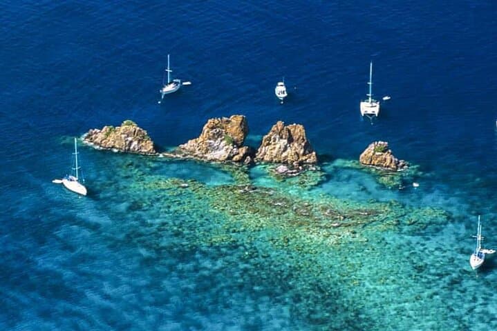
This self-guided mobile quest stitches together the British Virgin Islands’ best anchorages and characters: the granite jumbles of The Baths, the coral-carved wreck of the RMS Rhone, and Dead Chest Island’s legend of mutiny and marooning. Geologically, the islands rise from volcanic bedrock capped in wind-sculpted granite; culturally, the route traces centuries of seafaring, rum distilling and small-island hospitality—Foxy’s Bar and Cooper Island Beach Club both appear as stops in the narrative.
Expect a mix of short sails and longer hops: sheltered bays that demand careful kelp and coral watch, open channels where the current will test your heading, and shallow reefs that reward a slow drift and a mask.
Practical side: download the app and preload the tour and maps before you leave shore, charge devices and bring a waterproof case. Plan 8–24 hours depending on how many photo challenges and quiz stops you attempt. Respect mooring buoys and local anchoring rules—many spots are inside marine protected areas. Sync with tide and weather forecasts; afternoon squalls can arrive quickly and the North Sound channels can chop up.
The experience is equal parts navigation and storytelling: follow the audio to learn history and local lore, complete the digital treasure hunt, and finish at a scene that earns you the final riddle and a small, satisfying victory over map and myth.
easy.
8–24 hours.
Suitable for sailors with basic mobility; minimal physical exertion but requires boat handling ability
Yes — this is a self-guided digital tour for sailors; you must have access to a vessel (private charter, bareboat or crewed) to follow the route.
The tour is flexible: you can complete highlights in a full day (8 hours) or stretch the route into a multi-day cruise up to 24 hours of planned content and stops.
Yes — content and quizzes are family-friendly and the tour is rated accessible, but children should wear PFDs and be supervised on deck and during shore visits.
Preload the tour and offline maps before leaving port; the app provides audio stops and caches content so you can continue in low-coverage areas.
The BVI’s islands were shaped by volcanic activity and later became waypoints for Caribbean privateers and merchants; the wreck of the RMS Rhone is a maritime landmark tied to 19th-century sea travel.
Many popular anchorages lie within protected marine areas—use mooring buoys, avoid coral anchoring, and pack out all trash to limit impact.
Day Trips BVI operates guided outdoor trips and adventures with an emphasis on safety, stewardship, and memorable experiences.


The bow slips into turquoise water and the trade winds tugs at the mainsail like an impatient guide. You pull your phone from a dry pocket, tap the map, and the Jolly Pirate begins to tell you which cove dares you to come ashore next.
The bow slips into turquoise water and the trade winds tugs at the mainsail like an impatient guide. You pull your phone from a dry pocket, tap the map, and the Jolly Pirate begins to tell you which cove dares you to come ashore next.
This self-guided mobile quest stitches together the British Virgin Islands’ best anchorages and characters: the granite jumbles of The Baths, the coral-carved wreck of the RMS Rhone, and Dead Chest Island’s legend of mutiny and marooning. Geologically, the islands rise from volcanic bedrock capped in wind-sculpted granite; culturally, the route traces centuries of seafaring, rum distilling and small-island hospitality—Foxy’s Bar and Cooper Island Beach Club both appear as stops in the narrative.
Expect a mix of short sails and longer hops: sheltered bays that demand careful kelp and coral watch, open channels where the current will test your heading, and shallow reefs that reward a slow drift and a mask.
Practical side: download the app and preload the tour and maps before you leave shore, charge devices and bring a waterproof case. Plan 8–24 hours depending on how many photo challenges and quiz stops you attempt. Respect mooring buoys and local anchoring rules—many spots are inside marine protected areas. Sync with tide and weather forecasts; afternoon squalls can arrive quickly and the North Sound channels can chop up.
The experience is equal parts navigation and storytelling: follow the audio to learn history and local lore, complete the digital treasure hunt, and finish at a scene that earns you the final riddle and a small, satisfying victory over map and myth.