THE ADVENTURE COLLECTIVE® · Independent discovery and booking for outdoor travel

A full-day, high-altitude outing from Arequipa to the Pillones Waterfall and the Stone Forest of Imata. Expect steep rocky descents, bone-dry puna winds and surreal volcanic formations at roughly 4,000–4,600 m.
A full-day, high-altitude outing from Arequipa to the Pillones Waterfall and the Stone Forest of Imata. Expect steep rocky descents, bone-dry puna winds and surreal volcanic formations at roughly 4,000–4,600 m.
The morning air bites with altitude as the van eases away from Arequipa and the city’s colonial silhouette shrinks behind you. Roads push into puna grasslands, and after roughly two hours you stand at a high trailhead where cold wind and thin oxygen sharpen every breath. The route drops sharply for about 30 minutes over loose rock and river-stepped scree before the Pillones Waterfall appears—water daring the high plateau and silvering against black, volcanic stone.
Verified experiences and guided adventures in the surrounding area.
Operated by camino peru · Imata, Arequipa
The morning air bites with altitude as the van eases away from Arequipa and the city’s colonial silhouette shrinks behind you. Roads push into puna grasslands, and after roughly two hours you stand at a high trailhead where cold wind and thin oxygen sharpen every breath. The route drops sharply for about 30 minutes over loose rock and river-stepped scree before the Pillones Waterfall appears—water daring the high plateau and silvering against black, volcanic stone.
This landscape is shaped by Pleistocene glaciation, volcanic outflows and persistent freeze–thaw cycles; the Stone Forest of Imata is a geological gallery of eroded lava and compacted sediments that now resemble an otherworldly pine of stone. Local Quechua-speaking communities historically used this high ground for seasonal grazing, and Imata’s fields and simple stone buildings still reflect that pastoral rhythm.
Expect narrow, rocky descents, river-side paths and open highland plateaus. At 4,000–4,600 m elevation, weather is sudden: sun, wind and sleet can trade places within an hour. Photo stops at the falls and time to walk through the stone arches at Imata are built into a full-day itinerary that usually returns to Arequipa by early evening.
Practical: acclimatize in Arequipa a day or two, bring layered insulation, sturdy trekking shoes and gaiters, and plan slower steps on the descent to protect knees and ankles. Hydrate, use sun protection and keep a windproof shell handy—the high Andes demand respect but reward effort with stark, high-altitude views and intimate encounters with geological time.
challenging.
10–12 hours.
Should have good aerobic fitness and be acclimatized to high altitude; comfortable with steep, rocky descents.
About two hours each way to the trailhead, depending on traffic and road conditions; the full tour is typically around 10–12 hours.
Not recommended for unacclimatized beginners; the descent is steep and terrain can be technical, though no technical climbing gear is required.
Lunch in Imata is typically not included—bring snacks and money if you want a local meal in town.
The sites sit between roughly 4,000 and 4,600 meters above sea level; altitude symptoms are possible, so acclimatize beforehand.
The area lies within traditional Andean herding lands adjacent to the Salinas y Aguada Blanca Reserve, where local communities have grazed camelids for centuries.
Visitors should stick to trails, avoid disturbing grazing animals and take all trash back to Arequipa; the high puna is fragile and slow to recover from trampling.
camino peru operates guided outdoor trips and adventures with an emphasis on safety, stewardship, and memorable experiences.
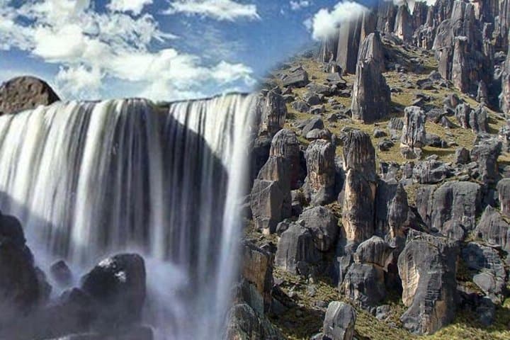


The morning air bites with altitude as the van eases away from Arequipa and the city’s colonial silhouette shrinks behind you. Roads push into puna grasslands, and after roughly two hours you stand at a high trailhead where cold wind and thin oxygen sharpen every breath. The route drops sharply for about 30 minutes over loose rock and river-stepped scree before the Pillones Waterfall appears—water daring the high plateau and silvering against black, volcanic stone.
The morning air bites with altitude as the van eases away from Arequipa and the city’s colonial silhouette shrinks behind you. Roads push into puna grasslands, and after roughly two hours you stand at a high trailhead where cold wind and thin oxygen sharpen every breath. The route drops sharply for about 30 minutes over loose rock and river-stepped scree before the Pillones Waterfall appears—water daring the high plateau and silvering against black, volcanic stone.
This landscape is shaped by Pleistocene glaciation, volcanic outflows and persistent freeze–thaw cycles; the Stone Forest of Imata is a geological gallery of eroded lava and compacted sediments that now resemble an otherworldly pine of stone. Local Quechua-speaking communities historically used this high ground for seasonal grazing, and Imata’s fields and simple stone buildings still reflect that pastoral rhythm.
Expect narrow, rocky descents, river-side paths and open highland plateaus. At 4,000–4,600 m elevation, weather is sudden: sun, wind and sleet can trade places within an hour. Photo stops at the falls and time to walk through the stone arches at Imata are built into a full-day itinerary that usually returns to Arequipa by early evening.
Practical: acclimatize in Arequipa a day or two, bring layered insulation, sturdy trekking shoes and gaiters, and plan slower steps on the descent to protect knees and ankles. Hydrate, use sun protection and keep a windproof shell handy—the high Andes demand respect but reward effort with stark, high-altitude views and intimate encounters with geological time.