THE ADVENTURE COLLECTIVE® · Independent discovery and booking for outdoor travel

Climb Pacaya’s ash-swept slopes from Guatemala City for close views of fumaroles and recent lava fields. This guided day trip mixes steep hiking, volcanic geology and sweeping valley views with practical, safety-focused guidance.
Climb Pacaya’s ash-swept slopes from Guatemala City for close views of fumaroles and recent lava fields. This guided day trip mixes steep hiking, volcanic geology and sweeping valley views with practical, safety-focused guidance.
A low sun slices across the volcanic plain as the minibus bumps toward Pacaya National Park; the air tastes faintly of sulfur and dry ash hushes the fields. Hikers step from cooled lava flows onto loose ash trails, feeling the ground give underfoot as fumaroles steam and the mountain seems to breathe. From the ridge the valley opens toward Antigua and distant peaks, while vents below hiss and push heat into the morning breeze.
Verified experiences and guided adventures in the surrounding area.
Operated by GTM Tour Guide and Travel Services · San Vicente Pacaya, Escuintla
A low sun slices across the volcanic plain as the minibus bumps toward Pacaya National Park; the air tastes faintly of sulfur and dry ash hushes the fields. Hikers step from cooled lava flows onto loose ash trails, feeling the ground give underfoot as fumaroles steam and the mountain seems to breathe. From the ridge the valley opens toward Antigua and distant peaks, while vents below hiss and push heat into the morning breeze.
Pacaya is an active stratovolcano rising to roughly 2,552 m (8,370 ft), with frequent small eruptions and a major event in 2010; until 2016 some routes allowed unusually close views of fresh lava. The route passes farmland, secondary forest and blackened lava fields—land shaped by recent geology and by generations of local farmers who manage coffee and corn on the flanks. Guides from nearby communities interpret volcanic behavior and keep groups at a safety distance from unstable vents.
Expect a steep 3.7 km ascent on dirt and loose ash that takes roughly 90–150 minutes one way depending on pace; the full tour runs about 6 hours including hotel pickup by air-conditioned minibus. Wear sturdy hiking boots, carry 2–3 liters of water, sun protection and a warm layer for wind at the summit. Follow your guide’s instructions around fumaroles—rocks and ash can shift, and volcanic gases concentrate in low spots. Morning and late-afternoon departures offer better light and cooler hiking; sunset tours can be dramatic but may require headlamps for the return. Check recent activity reports and respect closures—safety protocols change with the volcano’s mood.
moderate.
5–6 hours.
Moderate cardiovascular fitness and steady footing; expect steep sections and uneven terrain.
The main hiking section is about 3.7 km with steep, loose-asphalt and ash trails; most groups take 90–150 minutes up depending on pace.
Lava viewing used to be possible on some routes until 2016; guides now keep visitors at safe distances and access depends on current volcanic activity.
This tour is not recommended for pregnant travelers or those with serious back or heart conditions; children can join if they have the stamina for a steep hike and meet tour age policies.
Tours commonly allow full refunds if canceled at least 24 hours in advance; local operators may cancel for bad weather or volcanic activity.
Pacaya has been active since the 16th century and has shaped local agriculture and settlement patterns around Antigua and Escuintla.
Trails cross fragile volcanic soils and recovering lava fields—stay on established paths, pack out waste and follow guide rules to limit erosion and disturbance.
GTM Tour Guide and Travel Services operates guided outdoor trips and adventures with an emphasis on safety, stewardship, and memorable experiences.
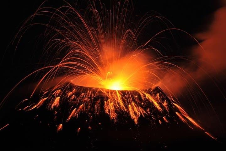


A low sun slices across the volcanic plain as the minibus bumps toward Pacaya National Park; the air tastes faintly of sulfur and dry ash hushes the fields. Hikers step from cooled lava flows onto loose ash trails, feeling the ground give underfoot as fumaroles steam and the mountain seems to breathe. From the ridge the valley opens toward Antigua and distant peaks, while vents below hiss and push heat into the morning breeze.
A low sun slices across the volcanic plain as the minibus bumps toward Pacaya National Park; the air tastes faintly of sulfur and dry ash hushes the fields. Hikers step from cooled lava flows onto loose ash trails, feeling the ground give underfoot as fumaroles steam and the mountain seems to breathe. From the ridge the valley opens toward Antigua and distant peaks, while vents below hiss and push heat into the morning breeze.
Pacaya is an active stratovolcano rising to roughly 2,552 m (8,370 ft), with frequent small eruptions and a major event in 2010; until 2016 some routes allowed unusually close views of fresh lava. The route passes farmland, secondary forest and blackened lava fields—land shaped by recent geology and by generations of local farmers who manage coffee and corn on the flanks. Guides from nearby communities interpret volcanic behavior and keep groups at a safety distance from unstable vents.
Expect a steep 3.7 km ascent on dirt and loose ash that takes roughly 90–150 minutes one way depending on pace; the full tour runs about 6 hours including hotel pickup by air-conditioned minibus. Wear sturdy hiking boots, carry 2–3 liters of water, sun protection and a warm layer for wind at the summit. Follow your guide’s instructions around fumaroles—rocks and ash can shift, and volcanic gases concentrate in low spots. Morning and late-afternoon departures offer better light and cooler hiking; sunset tours can be dramatic but may require headlamps for the return. Check recent activity reports and respect closures—safety protocols change with the volcano’s mood.