THE ADVENTURE COLLECTIVE® · Independent discovery and booking for outdoor travel

Lift off from Rotorua for a 40-minute helicopter tour that lands on Mt Tarawera, offering a 20-minute walk across volcanic terrain. Learn geology, hear local history from the pilot-guide, and photograph crater lakes and fissures up close.
Lift off from Rotorua for a 40-minute helicopter tour that lands on Mt Tarawera, offering a 20-minute walk across volcanic terrain. Learn geology, hear local history from the pilot-guide, and photograph crater lakes and fissures up close.
A low thrum rises under you as the helicopter lifts off Rotorua’s lakefront and the Northern Lakes spread like a carved map below. The pilot threads the aircraft between ridges and crater lakes—green, glass, and steam—until a black scar of volcanic rock appears: Mt Tarawera. You land on the flank of a dormant crater, step onto coarse ash and fractured lava, and spend twenty minutes moving through an open-air classroom of geology where steam vents and fissures outline a violent past.
Verified experiences and guided adventures in the surrounding area.
Operated by Volcanic Air · Rotorua, Bay of Plenty
A low thrum rises under you as the helicopter lifts off Rotorua’s lakefront and the Northern Lakes spread like a carved map below. The pilot threads the aircraft between ridges and crater lakes—green, glass, and steam—until a black scar of volcanic rock appears: Mt Tarawera. You land on the flank of a dormant crater, step onto coarse ash and fractured lava, and spend twenty minutes moving through an open-air classroom of geology where steam vents and fissures outline a violent past.
Tarawera sits on the Taupo Volcanic Zone; its 1886 eruption rerouted waterways, reshaped the shoreline of Lake Rotomahana and buried the famous Pink and White Terraces. Local Te Arawa iwi history is woven into the landscape—this is both a geological monument and a place of cultural stories passed down through generations.
Expect short walks over uneven volcanic rock, wide-angle views of crater lakes, and close-up shots of chilled lava flows and fumaroles. The aircraft commentary covers formation, eruption history, and the chain of basaltic ridges that define the region’s topography.
Practical essentials: flights are weather dependent and cancelled for poor conditions; weight restrictions apply per seat. Wear sturdy closed-toe shoes and layered outerwear—the exposed landing can be wind-chillier than Rotorua. Bring a camera with a polarizer if you want crater-lake reflections, and keep itineraries flexible: the whole trip is about 40 minutes with a 20-minute on-ground photo walk. The experience pairs easily with a full day exploring Rotorua’s geothermal parks and cultural centers.
easy.
40 minutes.
Suitable for most fitness levels; requires short 20-minute walk on uneven volcanic rock at landing site.
Allow about 40 minutes for the flight, which includes approximately 20 minutes on the ground at the volcano for photos and short walks.
Infants are allowed but must sit on an adult’s lap; specialized infant seats are available—check with the operator when booking.
Maximum weight per seat is 297 lbs (135 kg); passengers must disclose weight during booking to ensure aircraft balance and safety.
No—transfers are not included; participants should make their own way to the Volcanic Air office at Rotorua City Lakefront.
Mt Tarawera’s 1886 eruption dramatically altered the local landscape and buried the Pink and White Terraces; the site remains culturally significant to Te Arawa iwi.
Operators follow strict landing protocols to limit impact on fragile volcanic soils; visitors should stick to marked paths during the ground stop to protect geological features.
Volcanic Air operates guided outdoor trips and adventures with an emphasis on safety, stewardship, and memorable experiences.


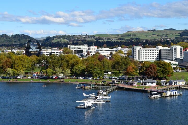
A low thrum rises under you as the helicopter lifts off Rotorua’s lakefront and the Northern Lakes spread like a carved map below. The pilot threads the aircraft between ridges and crater lakes—green, glass, and steam—until a black scar of volcanic rock appears: Mt Tarawera. You land on the flank of a dormant crater, step onto coarse ash and fractured lava, and spend twenty minutes moving through an open-air classroom of geology where steam vents and fissures outline a violent past.
A low thrum rises under you as the helicopter lifts off Rotorua’s lakefront and the Northern Lakes spread like a carved map below. The pilot threads the aircraft between ridges and crater lakes—green, glass, and steam—until a black scar of volcanic rock appears: Mt Tarawera. You land on the flank of a dormant crater, step onto coarse ash and fractured lava, and spend twenty minutes moving through an open-air classroom of geology where steam vents and fissures outline a violent past.
Tarawera sits on the Taupo Volcanic Zone; its 1886 eruption rerouted waterways, reshaped the shoreline of Lake Rotomahana and buried the famous Pink and White Terraces. Local Te Arawa iwi history is woven into the landscape—this is both a geological monument and a place of cultural stories passed down through generations.
Expect short walks over uneven volcanic rock, wide-angle views of crater lakes, and close-up shots of chilled lava flows and fumaroles. The aircraft commentary covers formation, eruption history, and the chain of basaltic ridges that define the region’s topography.
Practical essentials: flights are weather dependent and cancelled for poor conditions; weight restrictions apply per seat. Wear sturdy closed-toe shoes and layered outerwear—the exposed landing can be wind-chillier than Rotorua. Bring a camera with a polarizer if you want crater-lake reflections, and keep itineraries flexible: the whole trip is about 40 minutes with a 20-minute on-ground photo walk. The experience pairs easily with a full day exploring Rotorua’s geothermal parks and cultural centers.