THE ADVENTURE COLLECTIVE® · Independent discovery and booking for outdoor travel

A compact day hike that pairs a sub-800m summit with the striking boulder pools of Tinipak River. Expect steep trail pitches, clear river swims, and sweeping views of the Sierra Madre.
A compact day hike that pairs a sub-800m summit with the striking boulder pools of Tinipak River. Expect steep trail pitches, clear river swims, and sweeping views of the Sierra Madre.
Morning light breaks across the jagged boulders of Tinipak River and you step from a vehicle into a thicket of tall grass and limestone outcrops. The air smells of river-swept stone and wet earth; ahead, the trail angles up toward a serrated ridge that guards the Heart Peak summit. As you climb, the forest loosens and the Sierra Madre spreads a ragged line of peaks toward the east, the mountains daring you to look farther.
Verified experiences and guided adventures in the surrounding area.
Operated by Hike Manila · Tanay, Rizal
Morning light breaks across the jagged boulders of Tinipak River and you step from a vehicle into a thicket of tall grass and limestone outcrops. The air smells of river-swept stone and wet earth; ahead, the trail angles up toward a serrated ridge that guards the Heart Peak summit. As you climb, the forest loosens and the Sierra Madre spreads a ragged line of peaks toward the east, the mountains daring you to look farther.
Mount Daraitan (approx. 739 m) sits on the western rim of the Sierra Madre range. The river’s clear pools thread around colossal granite and quartz boulders carved over millennia; local farmers and Tagalog communities have used these paths for generations. Geologically the area is defined by resilient igneous and metamorphic rock shaped by rainfall and river action, which produces the dramatic boulder gardens that Tinipak is known for.
Expect a mixed trail: singletrack through bamboo and scrub, short steep pitches, and exposed rock slabs near the summit. The “Heart Peak” is a distinctive point for photos; the river’s shallow basins invite a cool soak after the climb. Cultural touches include small upland farms, roadside stalls selling snacks, and friendly local porters.
Practical guide: start early to avoid midday heat and afternoon rain; bring 2–3 liters of water, sturdy footwear with grip, and a small daypack. The route is suitable for hikers with moderate fitness and basic scrambling experience. Leave no trace on the river’s marble-like boulders and respect local trails—this stretch of the Sierra Madre responds quickly to heavy foot traffic and weather.
moderate.
8–12 hours.
Moderate — you should be comfortable with sustained uphill hiking, short scrambles, and returning after a long day.
Typical group itineraries run 8–12 hours door-to-door from Manila, with 3–5 hours on-trail depending on pace and stops.
The pools are generally safe for wading and swimming but watch for slippery rock, sudden depth changes, and strong sunlight; supervise children closely.
Local guides are recommended for first-time visitors for route familiarity and river crossings; permitting is managed locally—many tour operators include fees in the price.
Dry months (November–April) offer more stable trails; avoid peak typhoon season (July–October) due to heavy rain and flash-flood risk.
Traditional upland communities in Tanay have long used the river corridors for farming and salt trade routes; the area became popular with hikers in the last two decades as park access improved.
Heavy day-use and river swimming stress fragile bank vegetation and riverine systems; practice leave-no-trace, use established entry points, and minimize soap or sunscreen in pools.
Hike Manila operates guided outdoor trips and adventures with an emphasis on safety, stewardship, and memorable experiences.
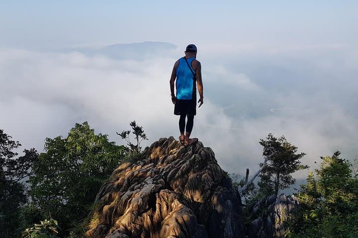


Morning light breaks across the jagged boulders of Tinipak River and you step from a vehicle into a thicket of tall grass and limestone outcrops. The air smells of river-swept stone and wet earth; ahead, the trail angles up toward a serrated ridge that guards the Heart Peak summit. As you climb, the forest loosens and the Sierra Madre spreads a ragged line of peaks toward the east, the mountains daring you to look farther.
Morning light breaks across the jagged boulders of Tinipak River and you step from a vehicle into a thicket of tall grass and limestone outcrops. The air smells of river-swept stone and wet earth; ahead, the trail angles up toward a serrated ridge that guards the Heart Peak summit. As you climb, the forest loosens and the Sierra Madre spreads a ragged line of peaks toward the east, the mountains daring you to look farther.
Mount Daraitan (approx. 739 m) sits on the western rim of the Sierra Madre range. The river’s clear pools thread around colossal granite and quartz boulders carved over millennia; local farmers and Tagalog communities have used these paths for generations. Geologically the area is defined by resilient igneous and metamorphic rock shaped by rainfall and river action, which produces the dramatic boulder gardens that Tinipak is known for.
Expect a mixed trail: singletrack through bamboo and scrub, short steep pitches, and exposed rock slabs near the summit. The “Heart Peak” is a distinctive point for photos; the river’s shallow basins invite a cool soak after the climb. Cultural touches include small upland farms, roadside stalls selling snacks, and friendly local porters.
Practical guide: start early to avoid midday heat and afternoon rain; bring 2–3 liters of water, sturdy footwear with grip, and a small daypack. The route is suitable for hikers with moderate fitness and basic scrambling experience. Leave no trace on the river’s marble-like boulders and respect local trails—this stretch of the Sierra Madre responds quickly to heavy foot traffic and weather.