THE ADVENTURE COLLECTIVE® · Independent discovery and booking for outdoor travel

A challenging day trek to Meesapulimala climbs exposed ridges, tea estates and shola forests to reach Munnar’s second-highest summit. Expect 6–8 hours of steady ascent, unpredictable weather, and wide views across the Western Ghats.
A challenging day trek to Meesapulimala climbs exposed ridges, tea estates and shola forests to reach Munnar’s second-highest summit. Expect 6–8 hours of steady ascent, unpredictable weather, and wide views across the Western Ghats.
You start before dawn, headlights cutting through tea-scented fog as the ridge line of Meesapulimalai appears like a low, breathing wall ahead. The trail climbs through alternating bands of open grassland and stunted shola forest; wind moves across the hills as if testing your resolve, and brooks dart down gullies, daring you to move faster.
Verified experiences and guided adventures in the surrounding area.
Operated by Carnival Tours Kochi · Munnar, Kerala
You start before dawn, headlights cutting through tea-scented fog as the ridge line of Meesapulimalai appears like a low, breathing wall ahead. The trail climbs through alternating bands of open grassland and stunted shola forest; wind moves across the hills as if testing your resolve, and brooks dart down gullies, daring you to move faster.
Meesapulimala stands at about 2,640 meters (8,661 ft) on the Kerala–Tamil Nadu border. Geologically the peak is part of the Western Ghats—ancient, weathered rock that forms steep ridges and pockets of high-altitude grassland. The region’s colonial-era history is visible in the long rows of tea bushes, remnants of estates that reshaped local land use and settlement patterns.
Culturally, the area blends Kerala highland traditions with Tamil influences; local guides often weave stories about hill tribes, plantation life, and seasonal harvests into the hike. Wildlife is shy but present—listen for birdcalls and watch exposed ridges for the silhouette of endemic species.
Practical guidance: this is a full-day, hard trek (6–8 hours) with steady elevation gain, narrow exposed sections and uneven trail. Start early for stable weather, carry layered clothing, at least 2–3 liters of water, and high-grip footwear. Expect muddy sections after rain and strong sun on exposed slopes—use sun protection. Private transfers and a local guide are typical for logistics and to navigate permit or access checks. Respect the fragile shola–grassland system by staying on trails and packing out waste. Finish with tea at a roadside stand—the simplest reward for a long climb.
challenging.
6–8 hours.
Good cardiovascular fitness and leg strength; comfortable with sustained uphill hiking and uneven terrain
It’s a full-day, hard trek with sustained climbs and some exposed, uneven trail—expect 6–8 hours and moderate-to-strong fitness requirements.
Local guides are common and recommended; access can involve private estate roads and informal checks at the border, so a guide or operator typically handles logistics.
Mountain weather is changeable—cool mornings, possible heavy afternoon rain during the monsoon, and strong sun when clear; prepare layers and rain protection.
At about 2,640 m the risk is moderate—most hikers are fine but ascend gradually, stay hydrated and know symptoms like headache or nausea.
The highlands around Munnar were reshaped by 19th–20th century colonial tea planting; many trails follow estate roads or former pack routes.
The shola–grassland ecosystem is fragile; stay on trails, avoid trampling vegetation and carry out all trash to limit erosion and habitat damage.
Carnival Tours Kochi operates guided outdoor trips and adventures with an emphasis on safety, stewardship, and memorable experiences.
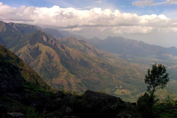
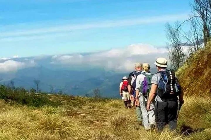
You start before dawn, headlights cutting through tea-scented fog as the ridge line of Meesapulimalai appears like a low, breathing wall ahead. The trail climbs through alternating bands of open grassland and stunted shola forest; wind moves across the hills as if testing your resolve, and brooks dart down gullies, daring you to move faster.
You start before dawn, headlights cutting through tea-scented fog as the ridge line of Meesapulimalai appears like a low, breathing wall ahead. The trail climbs through alternating bands of open grassland and stunted shola forest; wind moves across the hills as if testing your resolve, and brooks dart down gullies, daring you to move faster.
Meesapulimala stands at about 2,640 meters (8,661 ft) on the Kerala–Tamil Nadu border. Geologically the peak is part of the Western Ghats—ancient, weathered rock that forms steep ridges and pockets of high-altitude grassland. The region’s colonial-era history is visible in the long rows of tea bushes, remnants of estates that reshaped local land use and settlement patterns.
Culturally, the area blends Kerala highland traditions with Tamil influences; local guides often weave stories about hill tribes, plantation life, and seasonal harvests into the hike. Wildlife is shy but present—listen for birdcalls and watch exposed ridges for the silhouette of endemic species.
Practical guidance: this is a full-day, hard trek (6–8 hours) with steady elevation gain, narrow exposed sections and uneven trail. Start early for stable weather, carry layered clothing, at least 2–3 liters of water, and high-grip footwear. Expect muddy sections after rain and strong sun on exposed slopes—use sun protection. Private transfers and a local guide are typical for logistics and to navigate permit or access checks. Respect the fragile shola–grassland system by staying on trails and packing out waste. Finish with tea at a roadside stand—the simplest reward for a long climb.