THE ADVENTURE COLLECTIVE® · Independent discovery and booking for outdoor travel

A 10-day trek from Kathmandu into Langtang Valley that balances high alpine panoramas, Tamang village culture, and wildlife-rich forests. This guide covers what to expect on trail, practical logistics, and seasonal tips for a successful trek.
A 10-day trek from Kathmandu into Langtang Valley that balances high alpine panoramas, Tamang village culture, and wildlife-rich forests. This guide covers what to expect on trail, practical logistics, and seasonal tips for a successful trek.
Dawn breaks over Kathmandu and the city’s chaos gives way to mountain air as the road climbs toward Syabrubesi. On the trail the Bhote Koshi River dares you across suspension bridges, rhododendron trunks crowd the path, and the valley opens into stony meadows with Langtang Lirung rising like a patient giant.
Verified experiences and guided adventures in the surrounding area.
Operated by Worldwide Tourism Inc - Highly Recommended Travel Company · Kathmandu, Bagmati Province
Dawn breaks over Kathmandu and the city’s chaos gives way to mountain air as the road climbs toward Syabrubesi. On the trail the Bhote Koshi River dares you across suspension bridges, rhododendron trunks crowd the path, and the valley opens into stony meadows with Langtang Lirung rising like a patient giant.
Geology here is raw: glacial moraines, steep valley walls cut by rivers and recent earthquakes, and peaks carved by uplift and ice. Culturally the route threads Tamang and Sherpa settlements where mani stones and prayer flags mark centuries of Himalayan life. Langtang National Park protects mixed broadleaf and conifer forests, and the area’s recent recovery after the 2015 earthquake is visible in rebuilt teahouses and resilient communities.
Expect 4–6 hour walking days with sustained elevation gain up to 3,870 m at Kyanjin Gompa and an optional ascent to Tserko Ri (~4,984 m) for panoramic views. Terrain shifts from packed dirt and stone to loose scree and small glaciers near Kyanjin; some river crossings and steep switchbacks are typical. Accommodation is in family-run guesthouses (simple meals, shared bathrooms).
Practical essentials: pace your ascent and use the acclimatization day; carry water treatment and layered clothing for sudden wind and snow; trekking permits (TIMS and national park entry) are required; and allow one spare day for road delays returning to Kathmandu. The trail rewards steady effort with mountain clarity, cultural depth, and a real sense of having walked into the high Himalaya.
moderate.
10 days.
Good cardiovascular fitness and regular hiking experience; able to walk 4–6 hours a day with elevation gain and carry a daypack.
Yes — you need a TIMS card and Langtang National Park entry permit; your operator typically arranges these before departure.
Kyanjin Gompa sits at ~3,870 m; with sensible pacing and the acclimatization day you can manage without technical acclimatization, but be aware of AMS symptoms.
Yes — accommodations are family-run guesthouses with basic meals and occasional hot showers; book through your operator to support local businesses.
Spring (Mar–May) and fall (Sep–Nov) offer the most stable weather and clear views; monsoon brings rain and winter brings cold and limited services.
The Langtang Valley has long been home to Tamang communities and was significantly impacted by the 2015 earthquake; rebuilding efforts are ongoing and treks directly support local livelihoods.
Stick to established trails, avoid single-use plastics, and use local guides and teahouses to ensure economic benefits remain in the valley.
Worldwide Tourism Inc - Highly Recommended Travel Company operates guided outdoor trips and adventures with an emphasis on safety, stewardship, and memorable experiences.


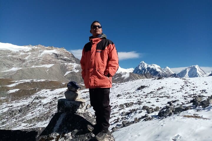

Dawn breaks over Kathmandu and the city’s chaos gives way to mountain air as the road climbs toward Syabrubesi. On the trail the Bhote Koshi River dares you across suspension bridges, rhododendron trunks crowd the path, and the valley opens into stony meadows with Langtang Lirung rising like a patient giant.
Dawn breaks over Kathmandu and the city’s chaos gives way to mountain air as the road climbs toward Syabrubesi. On the trail the Bhote Koshi River dares you across suspension bridges, rhododendron trunks crowd the path, and the valley opens into stony meadows with Langtang Lirung rising like a patient giant.
Geology here is raw: glacial moraines, steep valley walls cut by rivers and recent earthquakes, and peaks carved by uplift and ice. Culturally the route threads Tamang and Sherpa settlements where mani stones and prayer flags mark centuries of Himalayan life. Langtang National Park protects mixed broadleaf and conifer forests, and the area’s recent recovery after the 2015 earthquake is visible in rebuilt teahouses and resilient communities.
Expect 4–6 hour walking days with sustained elevation gain up to 3,870 m at Kyanjin Gompa and an optional ascent to Tserko Ri (~4,984 m) for panoramic views. Terrain shifts from packed dirt and stone to loose scree and small glaciers near Kyanjin; some river crossings and steep switchbacks are typical. Accommodation is in family-run guesthouses (simple meals, shared bathrooms).
Practical essentials: pace your ascent and use the acclimatization day; carry water treatment and layered clothing for sudden wind and snow; trekking permits (TIMS and national park entry) are required; and allow one spare day for road delays returning to Kathmandu. The trail rewards steady effort with mountain clarity, cultural depth, and a real sense of having walked into the high Himalaya.