THE ADVENTURE COLLECTIVE® · Independent discovery and booking for outdoor travel

A wild, off-trail day hike from Thangappuwa to Kota Ganga Ella in the Knuckles Mountain Range—expect steep climbs, mossy jungle, and a cluster of cascading falls reached best with a local guide. Plan for 6–8 hours, good boots, and leech protection.
A wild, off-trail day hike from Thangappuwa to Kota Ganga Ella in the Knuckles Mountain Range—expect steep climbs, mossy jungle, and a cluster of cascading falls reached best with a local guide. Plan for 6–8 hours, good boots, and leech protection.
Morning light slices through cloud and canopy as you step off the trailhead near Thangappuwa and begin the steady climb toward Kota Ganga Ella. The path alternates between narrow, root-stitched jungle tracks and open ridgelines where the wind tests your balance; somewhere below, the waterfall’s voice gathers into a distant promise.
Verified experiences and guided adventures in the surrounding area.
Operated by Travceylon Leisure · Kandy, Central Province
Morning light slices through cloud and canopy as you step off the trailhead near Thangappuwa and begin the steady climb toward Kota Ganga Ella. The path alternates between narrow, root-stitched jungle tracks and open ridgelines where the wind tests your balance; somewhere below, the waterfall’s voice gathers into a distant promise.
The Knuckles Mountain Range earns its name from a line of jagged peaks that rise abruptly from Sri Lanka’s central highlands. Geologically young and steep, the range traps moisture from seasonal winds, feeding the rivers and cascading falls that dot its flanks. Culturally the area has long been used by upland villagers for shifting agriculture and forest foraging—guides from nearby settlements still read animal trails and old footpaths humans use for generations.
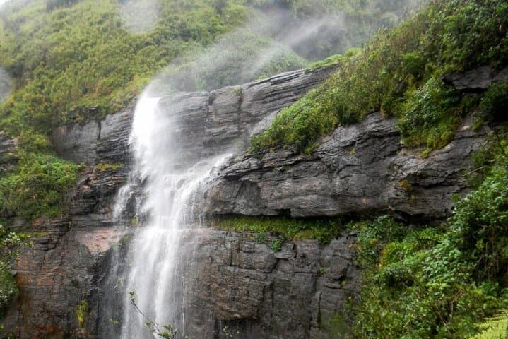
Kota Ganga is a multi-tiered cascade—seven main segments are described by local guides—sitting in dense montane forest with limited viewpoints rather than a single grand vista. Expect humid, moss-slick rock, sudden clearings of bright ferns, and pockets of endemic birdlife.
Practical guidance: the round-trip is roughly 11 km with around 5.5 km of sustained uphill; plan 6–8 hours including breaks. Good boots, leech protection and a knowledgeable guide are recommended because trails are indistinct and navigation can be tricky. Start early to avoid afternoon rain and to maximize light for photography. Carry at least 2 liters of water, layered clothing for changing mountain conditions, and respect local protocols—stay on the route your guide shows, pack out trash, and give wildlife space. The reward is close-range waterfall sections, cooling pools, and the rare satisfaction of reaching a place few day-hikers see.
challenging.
6–8 hours.
Suitable for hikers with good cardiovascular fitness and experience on uneven, sustained uphill terrain.
The itinerary is about 11 km round-trip with roughly 5.5 km uphill; expect 6–8 hours including breaks and photography.
Yes—local guides are strongly recommended because there is no well-established trail to the falls and guides know village paths and safe river crossings.
The area has common mountain wildlife and insects; leeches are the most frequent nuisance—avoid disturbing wildlife and follow your guide’s instructions.
The route is challenging with steep sections; it’s best for older teens and adults in good fitness—consult the operator if you have health concerns.
The Knuckles range takes its name from a row of sharp peaks; upland communities have long used footpaths through these forests for trade and shifting cultivation.
This area is ecologically sensitive—stay on routes guided by locals, carry out all trash, and avoid disturbing streamside vegetation to protect water quality and endemic species.
Travceylon Leisure operates guided outdoor trips and adventures with an emphasis on safety, stewardship, and memorable experiences.
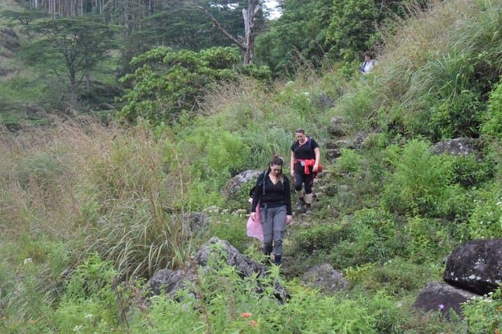
Morning light slices through cloud and canopy as you step off the trailhead near Thangappuwa and begin the steady climb toward Kota Ganga Ella. The path alternates between narrow, root-stitched jungle tracks and open ridgelines where the wind tests your balance; somewhere below, the waterfall’s voice gathers into a distant promise.
Morning light slices through cloud and canopy as you step off the trailhead near Thangappuwa and begin the steady climb toward Kota Ganga Ella. The path alternates between narrow, root-stitched jungle tracks and open ridgelines where the wind tests your balance; somewhere below, the waterfall’s voice gathers into a distant promise.
The Knuckles Mountain Range earns its name from a line of jagged peaks that rise abruptly from Sri Lanka’s central highlands. Geologically young and steep, the range traps moisture from seasonal winds, feeding the rivers and cascading falls that dot its flanks. Culturally the area has long been used by upland villagers for shifting agriculture and forest foraging—guides from nearby settlements still read animal trails and old footpaths humans use for generations.
Kota Ganga is a multi-tiered cascade—seven main segments are described by local guides—sitting in dense montane forest with limited viewpoints rather than a single grand vista. Expect humid, moss-slick rock, sudden clearings of bright ferns, and pockets of endemic birdlife.
Practical guidance: the round-trip is roughly 11 km with around 5.5 km of sustained uphill; plan 6–8 hours including breaks. Good boots, leech protection and a knowledgeable guide are recommended because trails are indistinct and navigation can be tricky. Start early to avoid afternoon rain and to maximize light for photography. Carry at least 2 liters of water, layered clothing for changing mountain conditions, and respect local protocols—stay on the route your guide shows, pack out trash, and give wildlife space. The reward is close-range waterfall sections, cooling pools, and the rare satisfaction of reaching a place few day-hikers see.