THE ADVENTURE COLLECTIVE® · Independent discovery and booking for outdoor travel

A four-day circuit from Hanoi into the Dong Van Karst Plateau that pairs high, sculpted limestone scenery with market mornings, river canyons and mountain hamlets. Expect dramatic viewpoints, narrow mountain roads and immersive local culture.
A four-day circuit from Hanoi into the Dong Van Karst Plateau that pairs high, sculpted limestone scenery with market mornings, river canyons and mountain hamlets. Expect dramatic viewpoints, narrow mountain roads and immersive local culture.
The bus eases out of Hanoi before dawn and the flat rice plains give way to cliffs that seem to rise like questions from the earth. By the time you reach the highlands the wind has a voice — it presses at the hairpin turns, tugs at jackets, dares you to step closer to the Ma Pi Leng escarpment where the Nho Que River threads the canyon below.
Verified experiences and guided adventures in the surrounding area.
Operated by Red Gecko Travel · Dong Van, Ha Giang
The bus eases out of Hanoi before dawn and the flat rice plains give way to cliffs that seem to rise like questions from the earth. By the time you reach the highlands the wind has a voice — it presses at the hairpin turns, tugs at jackets, dares you to step closer to the Ma Pi Leng escarpment where the Nho Que River threads the canyon below.
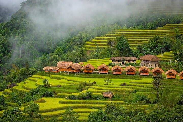
This four-day loop moves through the Dong Van Karst Plateau, a high limestone tableland sculpted by uplift and erosion over millions of years. Geology here reads like a slow-motion drama: caves, sharp pinnacles and the deep Tu San gorge carved 700–900m into carbonate rock. Culturally the region is equally layered — H’Mong, Dao and Tay communities keep traditional dress, markets and hilltop hamlets alive; Lung Cu Flag Tower marks Vietnam’s northernmost reach and the route has wartime history as a strategic corridor.
Expect long drives broken by viewpoint stops, a short afternoon trek to Lang Tay village, a market morning in Dong Van and a quiet boat glide on the Nho Que. The tour includes hotel stays, local meals and a guide; foreign travelers usually need a borderland permit or fee. Roads are narrow and weather can flip quickly — sun, wind and sudden rain are all part of the day.
Practical advice: wear layered clothing, sturdy shoes and a waterproof shell; carry water and ID copies for permits; plan for early starts and limited mobile signal. The region rewards patience: sunrise over the plateau and a market still waking are moments that make the trip worth the travel.
moderate.
4 days.
Moderate fitness — expect long vehicle transfers, short village treks and some standing at viewpoints; comfortable walking for 1–3 hours on uneven paths.
Yes — a borderland permission fee or approval is typically required for foreign visitors; the tour notes this fee and will advise on documentation and inclusion.
Mostly moderate: the trip includes extended road travel, short village treks (1–3 hours) and some standing at viewpoints — not technical but requires stamina for long days.
The advertised tour includes 2 nights in Ha Giang hotel and 1 night in Dong Van, plus breakfast, lunch and dinner counts as listed; check confirmation for exact meal details.
Yes if you wear a life jacket and follow the guide’s safety instructions; note river conditions vary by season and guides will adapt operations accordingly.
The plateau has long been home to H’Mong, Dao and Tay communities; many passes served as strategic routes during 20th-century conflicts and the Lung Cu tower marks a symbolic northern border point.
Tourism pressures and road construction affect fragile karst habitats; favor local homestays, avoid single-use plastics and follow trails to reduce erosion.
Red Gecko Travel operates guided outdoor trips and adventures with an emphasis on safety, stewardship, and memorable experiences.


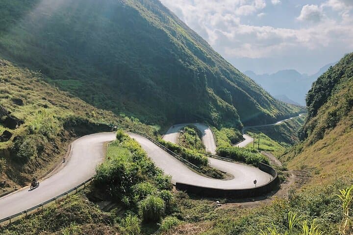
The bus eases out of Hanoi before dawn and the flat rice plains give way to cliffs that seem to rise like questions from the earth. By the time you reach the highlands the wind has a voice — it presses at the hairpin turns, tugs at jackets, dares you to step closer to the Ma Pi Leng escarpment where the Nho Que River threads the canyon below.
The bus eases out of Hanoi before dawn and the flat rice plains give way to cliffs that seem to rise like questions from the earth. By the time you reach the highlands the wind has a voice — it presses at the hairpin turns, tugs at jackets, dares you to step closer to the Ma Pi Leng escarpment where the Nho Que River threads the canyon below.
This four-day loop moves through the Dong Van Karst Plateau, a high limestone tableland sculpted by uplift and erosion over millions of years. Geology here reads like a slow-motion drama: caves, sharp pinnacles and the deep Tu San gorge carved 700–900m into carbonate rock. Culturally the region is equally layered — H’Mong, Dao and Tay communities keep traditional dress, markets and hilltop hamlets alive; Lung Cu Flag Tower marks Vietnam’s northernmost reach and the route has wartime history as a strategic corridor.
Expect long drives broken by viewpoint stops, a short afternoon trek to Lang Tay village, a market morning in Dong Van and a quiet boat glide on the Nho Que. The tour includes hotel stays, local meals and a guide; foreign travelers usually need a borderland permit or fee. Roads are narrow and weather can flip quickly — sun, wind and sudden rain are all part of the day.
Practical advice: wear layered clothing, sturdy shoes and a waterproof shell; carry water and ID copies for permits; plan for early starts and limited mobile signal. The region rewards patience: sunrise over the plateau and a market still waking are moments that make the trip worth the travel.