THE ADVENTURE COLLECTIVE® · Independent discovery and booking for outdoor travel

A compact two-day trek from Tauca to Huchuy Qosqo, this route crosses a 4,050 m Andean pass for expansive views of the Vilcanota range and quiet Inca ruins. Expect high-altitude puna, steep descents and culturally rich farming communities along the trail.
A compact two-day trek from Tauca to Huchuy Qosqo, this route crosses a 4,050 m Andean pass for expansive views of the Vilcanota range and quiet Inca ruins. Expect high-altitude puna, steep descents and culturally rich farming communities along the trail.
You climb out of the hum of the Sacred Valley before dawn, the bus dropping you at tiny Tauca (3,750 m) where cold air cuts like a promise. The first kilometers run on flat fields of corn and quinoa, then the trail angers upward through ichu grass to a high pass at about 4,050 m. From that ridge the Vilcanota range opens—Veronica, Pitusiray, Chicon and San Juan—snow and rock stacking into a skyline that dares you to keep moving.
Verified experiences and guided adventures in the surrounding area.
Operated by Antisuyo Travel · Calca, Cusco Region
You climb out of the hum of the Sacred Valley before dawn, the bus dropping you at tiny Tauca (3,750 m) where cold air cuts like a promise. The first kilometers run on flat fields of corn and quinoa, then the trail angers upward through ichu grass to a high pass at about 4,050 m. From that ridge the Vilcanota range opens—Veronica, Pitusiray, Chicon and San Juan—snow and rock stacking into a skyline that dares you to keep moving.
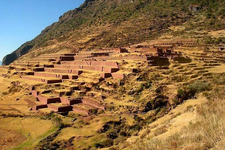
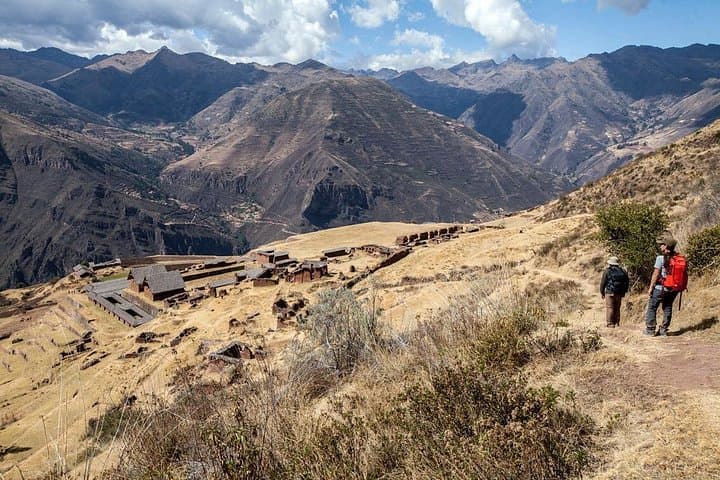
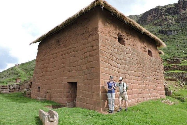
Huchuy Qosqo (roughly 3,400 m) is an intimate Inca complex with terraces, stonework and agricultural features that speak to the valley’s role in food production and polity. Geologically the route moves from fertile valley soils to puna—thin, rocky ground where hard grasses and cacti cling to life. Ccauca and Leon Punku ravines cut the walk with archaeological hints: remnants of bridges, sections of Inca trail and pockets where tarwi and native tubers still grow.
Culturally you’ll pass farming communities that still use coca tea to fight altitude; local stonemasonry echoes centuries of craft. Plan for two days of trekking with significant altitude gain and steep descents. Carry layered clothing, a 2–3 liter hydration system, sun protection and snacks; expect loose rock, narrow terraces and short steep pitches.
Acclimatize in Cusco or Calca for 24–48 hours before departure, pace uphill sections, and treat coca tea and rest seriously. Weather can cancel passes—bring a waterproof shell and be ready to reposition plans. The route rewards effort with quiet ruins, sweeping highland light and a direct line to Inca landscape engineering.
challenging.
2 days (≈48 hours).
Requires high-altitude endurance and good cardiovascular fitness; comfortable with sustained uphill and downhill hiking.
The trail gains about 300–400 m from Tauca to the pass with sustained uphill sections; pace yourself and expect thin air above 4,000 m.
Yes—local guides know route conditions, manage logistics and interpret archaeological sites; this route is commonly run with an operator for safety and access.
Most departures are a two-day itinerary with an overnight—accommodation styles vary by operator from basic lodges to camping; confirm when booking.
Yes—Huchuy Qosqo is a smaller, less-visited complex with terraces and stone constructions; you’ll also encounter fragments of old Inca trail and bridge remains in the ravines.
Huchuy Qosqo was an agricultural and administrative outpost for the Incas, positioned to control and farm high-elevation terraces in the Sacred Valley.
Trails cross fragile puna ecosystems—stay on established paths, pack out waste and respect local farming plots to reduce erosion and disturbance.
Antisuyo Travel operates guided outdoor trips and adventures with an emphasis on safety, stewardship, and memorable experiences.
You climb out of the hum of the Sacred Valley before dawn, the bus dropping you at tiny Tauca (3,750 m) where cold air cuts like a promise. The first kilometers run on flat fields of corn and quinoa, then the trail angers upward through ichu grass to a high pass at about 4,050 m. From that ridge the Vilcanota range opens—Veronica, Pitusiray, Chicon and San Juan—snow and rock stacking into a skyline that dares you to keep moving.
You climb out of the hum of the Sacred Valley before dawn, the bus dropping you at tiny Tauca (3,750 m) where cold air cuts like a promise. The first kilometers run on flat fields of corn and quinoa, then the trail angers upward through ichu grass to a high pass at about 4,050 m. From that ridge the Vilcanota range opens—Veronica, Pitusiray, Chicon and San Juan—snow and rock stacking into a skyline that dares you to keep moving.
Huchuy Qosqo (roughly 3,400 m) is an intimate Inca complex with terraces, stonework and agricultural features that speak to the valley’s role in food production and polity. Geologically the route moves from fertile valley soils to puna—thin, rocky ground where hard grasses and cacti cling to life. Ccauca and Leon Punku ravines cut the walk with archaeological hints: remnants of bridges, sections of Inca trail and pockets where tarwi and native tubers still grow.
Culturally you’ll pass farming communities that still use coca tea to fight altitude; local stonemasonry echoes centuries of craft. Plan for two days of trekking with significant altitude gain and steep descents. Carry layered clothing, a 2–3 liter hydration system, sun protection and snacks; expect loose rock, narrow terraces and short steep pitches.
Acclimatize in Cusco or Calca for 24–48 hours before departure, pace uphill sections, and treat coca tea and rest seriously. Weather can cancel passes—bring a waterproof shell and be ready to reposition plans. The route rewards effort with quiet ruins, sweeping highland light and a direct line to Inca landscape engineering.