THE ADVENTURE COLLECTIVE® · Independent discovery and booking for outdoor travel

A compact, history-steeped hike on the slopes above the Alhambra that moves through Mediterranean oak and repopulated pine to viewpoints over Sacromonte and the Darro valley. This practical guide explains what to expect on the Cerro del Sol routes and how to prepare.
A compact, history-steeped hike on the slopes above the Alhambra that moves through Mediterranean oak and repopulated pine to viewpoints over Sacromonte and the Darro valley. This practical guide explains what to expect on the Cerro del Sol routes and how to prepare.
You round a low stone wall and the view opens: the Alhambra’s ornamented skyline on your left, a scrubbed hillside on your right that climbs into Cerro del Sol. The air smells of rosemary and pine; the trail underfoot alternates between packed earth, loose shale and exposed roots as it threads through holm oaks and repopulated pines. Occasional clearings offer views toward Sacromonte and the Darro valley — the city below seems to hold its breath.
Verified experiences and guided adventures in the surrounding area.
You round a low stone wall and the view opens: the Alhambra’s ornamented skyline on your left, a scrubbed hillside on your right that climbs into Cerro del Sol. The air smells of rosemary and pine; the trail underfoot alternates between packed earth, loose shale and exposed roots as it threads through holm oaks and repopulated pines. Occasional clearings offer views toward Sacromonte and the Darro valley — the city below seems to hold its breath.
This route follows age-old access routes to the Alhambra, used historically by local farmers and later by city residents seeking the hilltops. Geologically you’re on the southern foothills of the Sierra Nevada, where weathered limestone and clay produce steep, erodible tracks and the Mediterranean scrub dominates. Culturally, the slopes have long been shaped by grazing and fire management; paths like Avellano and those from the San José cemetery carry practical, history-laden names rather than tourist flair.
Expect a 3-hour outing of roughly 5–7 km round trip with 200–300 m of ascent depending on the variant you choose. Trails vary: some are wide forest lanes, others narrow, unreliable goat paths that require careful foot placement. Water is scarce on the hill and shade is intermittent in summer; the sun will push at you up the northeastern slopes that face Sacromonte.
Practical guidance: start early to avoid heat, wear grippy boots for shale sections, bring navigation (phone map or printed), and stick to established tracks to protect aromatic scrub and reduce erosion. With basic preparation this is a compact, scenic hike that connects Granada’s urban core to the wild edge of the Sierra Nevada foothills.
moderate.
3 hours.
Comfortable walking fitness; able to sustain climbs of 200–300 m and manage uneven, rocky terrain.
Most variants take about 3 hours round-trip, covering roughly 5–7 km with 200–300 m of ascent; difficulty is moderate due to uneven footing and some steep sections.
Common access points include the Avellano trail, the old road from San José cemetery, and forest lanes behind the Silla del Moro—each leads up to Cerro del Sol from different directions.
No special permit is needed; these are public trails on the outskirts of Granada’s protected landscape, but local regulations on access and dogs may apply.
Some main forest lanes are evident, but many connecting paths are informal and unreliable—bring a map or GPS and follow established tracks to avoid getting off-route.
Trails here trace historic access to the Alhambra and surrounding farms; many routes evolved from agricultural tracks and cemetery roads used by local communities.
The area is sensitive to erosion and fire; stay on marked tracks, avoid trampling aromatic scrub, and follow local fire restrictions to protect regrown pine stands.
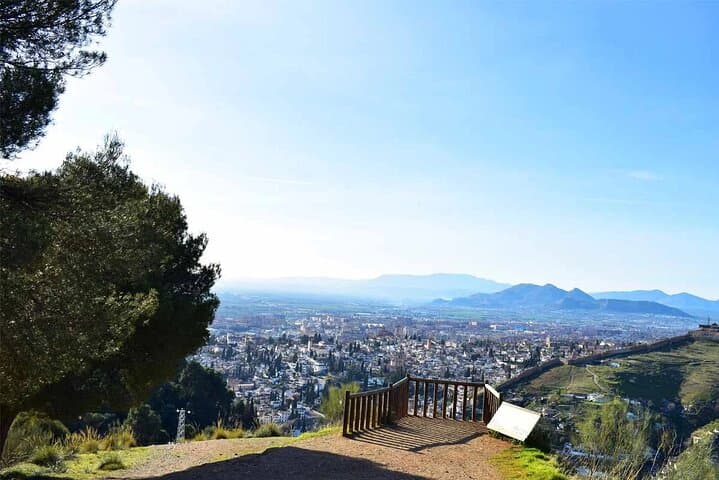
You round a low stone wall and the view opens: the Alhambra’s ornamented skyline on your left, a scrubbed hillside on your right that climbs into Cerro del Sol. The air smells of rosemary and pine; the trail underfoot alternates between packed earth, loose shale and exposed roots as it threads through holm oaks and repopulated pines. Occasional clearings offer views toward Sacromonte and the Darro valley — the city below seems to hold its breath.
You round a low stone wall and the view opens: the Alhambra’s ornamented skyline on your left, a scrubbed hillside on your right that climbs into Cerro del Sol. The air smells of rosemary and pine; the trail underfoot alternates between packed earth, loose shale and exposed roots as it threads through holm oaks and repopulated pines. Occasional clearings offer views toward Sacromonte and the Darro valley — the city below seems to hold its breath.
This route follows age-old access routes to the Alhambra, used historically by local farmers and later by city residents seeking the hilltops. Geologically you’re on the southern foothills of the Sierra Nevada, where weathered limestone and clay produce steep, erodible tracks and the Mediterranean scrub dominates. Culturally, the slopes have long been shaped by grazing and fire management; paths like Avellano and those from the San José cemetery carry practical, history-laden names rather than tourist flair.
Expect a 3-hour outing of roughly 5–7 km round trip with 200–300 m of ascent depending on the variant you choose. Trails vary: some are wide forest lanes, others narrow, unreliable goat paths that require careful foot placement. Water is scarce on the hill and shade is intermittent in summer; the sun will push at you up the northeastern slopes that face Sacromonte.
Practical guidance: start early to avoid heat, wear grippy boots for shale sections, bring navigation (phone map or printed), and stick to established tracks to protect aromatic scrub and reduce erosion. With basic preparation this is a compact, scenic hike that connects Granada’s urban core to the wild edge of the Sierra Nevada foothills.