THE ADVENTURE COLLECTIVE® · Independent discovery and booking for outdoor travel

A full-day trip from Marrakech into the High Atlas to Imlil offers mint-tea welcomes, mule-track walking through orchards and a family lunch with views of Toubkal. Expect steep, scenic trails, traditional Berber culture, and a waterfall en route.
A full-day trip from Marrakech into the High Atlas to Imlil offers mint-tea welcomes, mule-track walking through orchards and a family lunch with views of Toubkal. Expect steep, scenic trails, traditional Berber culture, and a waterfall en route.
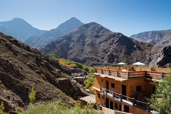
You step out of Marrakech’s dust and heat into a cooler, mountain-scented air as the road climbs toward the High Atlas. Villages appear as stacked brown houses on terraced slopes; walnut and cherry trees stripe the valley. Imlil sits at 1,740 m, a gateway village where mint tea and a local guide mark the start of a day that moves between mule track, paved mule-stone, and narrow footpaths.
Verified experiences and guided adventures in the surrounding area.
Operated by Sundunes Experience · Imlil, Marrakesh-Safi
You step out of Marrakech’s dust and heat into a cooler, mountain-scented air as the road climbs toward the High Atlas. Villages appear as stacked brown houses on terraced slopes; walnut and cherry trees stripe the valley. Imlil sits at 1,740 m, a gateway village where mint tea and a local guide mark the start of a day that moves between mule track, paved mule-stone, and narrow footpaths.
The High Atlas has been home to Amazigh (Berber) communities for centuries; irrigation channels and terraced fields here date to long-standing agricultural traditions. Geologically the range is forged of metamorphic and igneous rocks, carved into steep ravines by seasonal streams that swell in spring. Culture is visible in stone homes, rooftop drying racks, and family-run guesthouses; the route to Armed (≈1,900 m) gives a clear view toward Toubkal (4,167 m), North Africa’s highest peak.
Expect uneven, sometimes steep terrain and short sections of loose scree near village approaches. The walk includes shaded orchards, a waterfall crossing, and panoramic overlooks of the Aït Mizane valley. Local guides arrange a family lunch with mountain views and explain irrigation systems and village life.
Practical notes: plan for a full day (roughly 6–8 hours including transfers), bring layered clothing for temperature swings, and carry 1–2 liters of water. Mules are available for steep or tired sections but reserve spots early. Start early to avoid afternoon heat and give yourself time for the descent and return drive to Marrakech.
moderate.
6–8 hours (full-day, including transfers).
Able to handle sustained uphill walking with some uneven terrain; basic cardio and ankle stability recommended
The transfer is about 60–75 km and typically takes 1.5–2 hours depending on traffic and stops at market towns.
Yes — the tour usually includes a shared lunch with a Berber family featuring local salads, tagine, bread and mint tea, served with mountain views.
Yes, mules are available for portions of the route; availability can be limited, so request a mule in advance if needed.
The highest point visited is around 1,900 m, which is unlikely to cause altitude sickness for most people, but take it easy if you’re sensitive to elevation.
Imlil has long been a high-altitude farming and guide village; it serves as a historic staging point for ascents of Toubkal and seasonal trade between mountain communities and Marrakech.
The valleys depend on ancient irrigation (seguias) and are sensitive to water use and litter; support village businesses, stick to paths, and pack out waste to minimize impact.
Sundunes Experience operates guided outdoor trips and adventures with an emphasis on safety, stewardship, and memorable experiences.
You step out of Marrakech’s dust and heat into a cooler, mountain-scented air as the road climbs toward the High Atlas. Villages appear as stacked brown houses on terraced slopes; walnut and cherry trees stripe the valley. Imlil sits at 1,740 m, a gateway village where mint tea and a local guide mark the start of a day that moves between mule track, paved mule-stone, and narrow footpaths.
You step out of Marrakech’s dust and heat into a cooler, mountain-scented air as the road climbs toward the High Atlas. Villages appear as stacked brown houses on terraced slopes; walnut and cherry trees stripe the valley. Imlil sits at 1,740 m, a gateway village where mint tea and a local guide mark the start of a day that moves between mule track, paved mule-stone, and narrow footpaths.
The High Atlas has been home to Amazigh (Berber) communities for centuries; irrigation channels and terraced fields here date to long-standing agricultural traditions. Geologically the range is forged of metamorphic and igneous rocks, carved into steep ravines by seasonal streams that swell in spring. Culture is visible in stone homes, rooftop drying racks, and family-run guesthouses; the route to Armed (≈1,900 m) gives a clear view toward Toubkal (4,167 m), North Africa’s highest peak.
Expect uneven, sometimes steep terrain and short sections of loose scree near village approaches. The walk includes shaded orchards, a waterfall crossing, and panoramic overlooks of the Aït Mizane valley. Local guides arrange a family lunch with mountain views and explain irrigation systems and village life.
Practical notes: plan for a full day (roughly 6–8 hours including transfers), bring layered clothing for temperature swings, and carry 1–2 liters of water. Mules are available for steep or tired sections but reserve spots early. Start early to avoid afternoon heat and give yourself time for the descent and return drive to Marrakech.