THE ADVENTURE COLLECTIVE® · Independent discovery and booking for outdoor travel

Walk across Yakehashiri’s black lava, circle the Hachimantai summit and relax by steaming onsen before a photo stop at Lake Tazawa’s torii. This full-day Tohoku route blends volcanic geology, seasonal spectacles like the Dragon Eye and accessible alpine hiking.
Walk across Yakehashiri’s black lava, circle the Hachimantai summit and relax by steaming onsen before a photo stop at Lake Tazawa’s torii. This full-day Tohoku route blends volcanic geology, seasonal spectacles like the Dragon Eye and accessible alpine hiking.
You step off at a basalt plain where black lava fingers still trace the slope and a cold wind pushes the smell of steam across the trail. The Yakehashiri lava field opens like a raw scar from an older eruption; beyond it the Hachimantai summit rises, ridged and blanketed in seasonally shifting weather.
Verified experiences and guided adventures in the surrounding area.
Operated by Northern Japan Horizons · Morioka, Iwate
You step off at a basalt plain where black lava fingers still trace the slope and a cold wind pushes the smell of steam across the trail. The Yakehashiri lava field opens like a raw scar from an older eruption; beyond it the Hachimantai summit rises, ridged and blanketed in seasonally shifting weather.
This route threads volcanic geology, hot-spring culture and lake-side panoramas. Hachimantai sits on the volcanic front of northern Honshu—ancient eruptions created lava flows and high moorland, while geothermal activity feeds Goshogake and Tamagawa onsens. Locals have long harvested the area’s natural heat for baths and mineral-rich cuisine; Lake Tazawa’s torii marks one of Japan’s deepest lakes and a site of regional folklore.
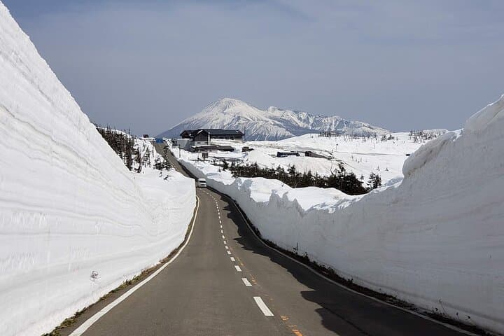
Expect mixed terrain: packed volcanic rock, boardwalks near fumaroles, and alpine trail above treeline. Distances vary by season but typical walking totals 4–8 km with up to ~300–400 m cumulative ascent depending on the summit loop chosen. In spring you may be snowshoeing and watching the Dragon Eye form; in summer the plateau blooms; in fall the slopes turn bright; winter locks much of the road in deep snow.
Practical edge: layer for sudden wind and sun, wear boots with decent tread, and bring 1–2 liters of water and sunscreen. Allow a full day—this itinerary commonly runs nine to ten hours with transfers from Morioka Station. Respect geothermal areas (stay on paths), time photography for softer morning light, and budget cash for onsen meals. The land here is active and deliberate; move through it with attention and good gear.
moderate.
9–10 hours.
Suitable for people with regular walking fitness; ability to handle several hours of mixed-terrain hiking and short elevation gains required.
Hiking is generally moderate: short ascents and uneven volcanic terrain but no technical climbing—routes are adaptable by season and guides set pace for group ability.
Dragon Eye typically appears late May to early June as melt patterns form on the summit pond—timing varies with winter snowfall and spring temperatures.
The itinerary includes a lunch stop at Goshogake Onsen and time at geothermal areas, but private bathing costs or paid facilities may be extra—carry cash just in case.
Yes—routes adapt seasonally: snowshoe options in spring, accessible alpine walks in summer, vivid fall colors, and heavy snow conditions that restrict access in mid-winter.
Volcanic activity over millennia shaped the Hachimantai plateau; local settlements have long used geothermal features for bathing and folk medicine.
Alpine vegetation and geothermal features are fragile—stay on marked trails, avoid touching fumaroles, and pack out all waste to protect hot-spring ecology.
Northern Japan Horizons operates guided outdoor trips and adventures with an emphasis on safety, stewardship, and memorable experiences.


You step off at a basalt plain where black lava fingers still trace the slope and a cold wind pushes the smell of steam across the trail. The Yakehashiri lava field opens like a raw scar from an older eruption; beyond it the Hachimantai summit rises, ridged and blanketed in seasonally shifting weather.
You step off at a basalt plain where black lava fingers still trace the slope and a cold wind pushes the smell of steam across the trail. The Yakehashiri lava field opens like a raw scar from an older eruption; beyond it the Hachimantai summit rises, ridged and blanketed in seasonally shifting weather.
This route threads volcanic geology, hot-spring culture and lake-side panoramas. Hachimantai sits on the volcanic front of northern Honshu—ancient eruptions created lava flows and high moorland, while geothermal activity feeds Goshogake and Tamagawa onsens. Locals have long harvested the area’s natural heat for baths and mineral-rich cuisine; Lake Tazawa’s torii marks one of Japan’s deepest lakes and a site of regional folklore.
Expect mixed terrain: packed volcanic rock, boardwalks near fumaroles, and alpine trail above treeline. Distances vary by season but typical walking totals 4–8 km with up to ~300–400 m cumulative ascent depending on the summit loop chosen. In spring you may be snowshoeing and watching the Dragon Eye form; in summer the plateau blooms; in fall the slopes turn bright; winter locks much of the road in deep snow.
Practical edge: layer for sudden wind and sun, wear boots with decent tread, and bring 1–2 liters of water and sunscreen. Allow a full day—this itinerary commonly runs nine to ten hours with transfers from Morioka Station. Respect geothermal areas (stay on paths), time photography for softer morning light, and budget cash for onsen meals. The land here is active and deliberate; move through it with attention and good gear.