THE ADVENTURE COLLECTIVE® · Independent discovery and booking for outdoor travel

Ride the Ha Giang Loop from Hanoi to the Dong Van Plateau on a short but intense motorbike circuit. Expect narrow mountain roads, soaring passes like Ma Pi Leng, and hands-on encounters with H’Mong culture.
Ride the Ha Giang Loop from Hanoi to the Dong Van Plateau on a short but intense motorbike circuit. Expect narrow mountain roads, soaring passes like Ma Pi Leng, and hands-on encounters with H’Mong culture.
The ride begins before dawn on a sleeping bus out of Hanoi, then gives way to a spine of road that climbs into northern Vietnam’s highlands. Narrow asphalt threads up through corn terraces and limestone shoulders; wind tests your balance and the mountains answer with sheer drops and sudden panoramas.
Verified experiences and guided adventures in the surrounding area.
Operated by LOCAL TOURS VIETNAM · Ha Giang, Ha Giang
The ride begins before dawn on a sleeping bus out of Hanoi, then gives way to a spine of road that climbs into northern Vietnam’s highlands. Narrow asphalt threads up through corn terraces and limestone shoulders; wind tests your balance and the mountains answer with sheer drops and sudden panoramas.
This route crosses the Dong Van Karst Plateau, an uplifted field of weather-scoured limestone formed over millions of years. Villages along the loop preserve strong H’Mong and Dao traditions—stone houses, embroidered textiles and the Vuong family mansion in Sa Phin, a reminder of local leadership during the French era.
Riders encounter the signature features of the loop: steep switchbacks, the Quan Ba Heaven Gate outlook, and the Ma Pi Leng spine—about 1,200–1,500 m elevation—where the road clings above the Nho Que canyon. The Nho Que River cuts a green ribbon through Tu San canyon; small boats reveal a different scale of the landscape.
Practical guidance: the full loop is roughly 250–320 km depending on side trips, spread over two riding days with long stints in the saddle and short cultural stops. Roads are mostly paved but narrow, with occasional gravel patches; expect slow, technical sections and variable weather. Plan on layered clothing, a reliable helmet, and a local guide or “easy rider” driver if you’re not confident handling mountain roads. Hydrate, break often, and schedule daylight riding—sunrise and late afternoon bring the clearest views and the trickiest shadows on the passes.
moderate.
2–3 days.
Suitable for travelers in average fitness who can tolerate long hours seated and short on-foot visits; not physically demanding but requires endurance for back-to-back riding days.
No—many operators offer an easy-rider option where a trained local drives you as a pillion; self-ride is possible if you have appropriate experience and license.
The core loop covers roughly 250–320 km with popular stops; the tour is structured over 2–3 days of riding with overnight stops in homestays or Dong Van.
Mountain roads are narrow with tight switchbacks; novices should opt for an easy-rider or take a guided car option rather than self-riding.
Bring Vietnamese dong for rural purchases and small services; English is spoken by some guides but limited in villages—download offline translation tools or carry key phrases.
The Dong Van Plateau was shaped by limestone uplift and served as a cultural crossroads for H’Mong and Dao peoples; the Vuong family mansion in Sa Phin reflects 20th-century local power and French colonial influence.
The karst plateau is ecologically sensitive and faces pressure from rising tourism; practice Leave No Trace, support local homestays, and avoid off-trail driving.
LOCAL TOURS VIETNAM operates guided outdoor trips and adventures with an emphasis on safety, stewardship, and memorable experiences.
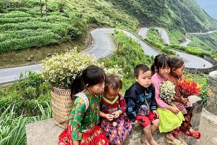

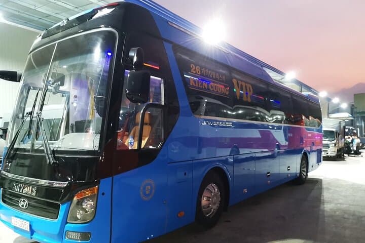

The ride begins before dawn on a sleeping bus out of Hanoi, then gives way to a spine of road that climbs into northern Vietnam’s highlands. Narrow asphalt threads up through corn terraces and limestone shoulders; wind tests your balance and the mountains answer with sheer drops and sudden panoramas.
The ride begins before dawn on a sleeping bus out of Hanoi, then gives way to a spine of road that climbs into northern Vietnam’s highlands. Narrow asphalt threads up through corn terraces and limestone shoulders; wind tests your balance and the mountains answer with sheer drops and sudden panoramas.
This route crosses the Dong Van Karst Plateau, an uplifted field of weather-scoured limestone formed over millions of years. Villages along the loop preserve strong H’Mong and Dao traditions—stone houses, embroidered textiles and the Vuong family mansion in Sa Phin, a reminder of local leadership during the French era.
Riders encounter the signature features of the loop: steep switchbacks, the Quan Ba Heaven Gate outlook, and the Ma Pi Leng spine—about 1,200–1,500 m elevation—where the road clings above the Nho Que canyon. The Nho Que River cuts a green ribbon through Tu San canyon; small boats reveal a different scale of the landscape.
Practical guidance: the full loop is roughly 250–320 km depending on side trips, spread over two riding days with long stints in the saddle and short cultural stops. Roads are mostly paved but narrow, with occasional gravel patches; expect slow, technical sections and variable weather. Plan on layered clothing, a reliable helmet, and a local guide or “easy rider” driver if you’re not confident handling mountain roads. Hydrate, break often, and schedule daylight riding—sunrise and late afternoon bring the clearest views and the trickiest shadows on the passes.