THE ADVENTURE COLLECTIVE® · Independent discovery and booking for outdoor travel

Drive a dramatic highland loop from Hanoi to the Dong Van Karst Plateau: Ma Pi Leng’s sunrise, boat rides on the Nho Que River, and encounters with Hmong and Dao communities. Expect long drives, narrow passes, and vivid cultural stops.
Drive a dramatic highland loop from Hanoi to the Dong Van Karst Plateau: Ma Pi Leng’s sunrise, boat rides on the Nho Que River, and encounters with Hmong and Dao communities. Expect long drives, narrow passes, and vivid cultural stops.
You step off an overnight bus into a cool, thin air as the road yawns open above the Tu San gorge; the wind here seems to push you forward and the mountains answer with a raw, stony hush.
Verified experiences and guided adventures in the surrounding area.
Operated by Tiger Tourist · Ha Giang, Ha Giang Province
You step off an overnight bus into a cool, thin air as the road yawns open above the Tu San gorge; the wind here seems to push you forward and the mountains answer with a raw, stony hush.
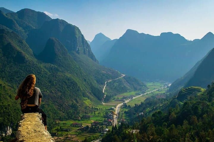
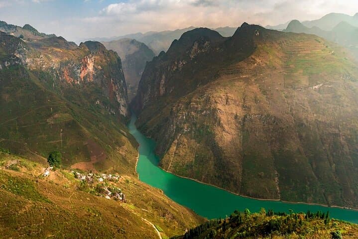
The Ha Giang Loop runs across the Dong Van Karst Plateau — a UNESCO-recognized landscape of weathered limestone ridges, steep passes and terraced fields. Geology here reads like a slow-motion novel: limestone uplifted and sculpted into cliffs and spires, with deep canyons that channel rainfall into the emerald thread of the Nho Que (Tu San) River below.
Culturally the route threads Hmong, Tay and Dao communities; in Dong Van’s old quarter you’ll hear tonal languages and see hand-loomed brocade, while Lung Tam still practices a 41-step textile craft. Historical notes surface at Lung Cu Flag Tower — the symbolic northern marker — and in stories of strategic mountain routes used during 20th-century conflicts.
Practically, this guided loop is bus-forward with short walks, viewpoint stops and a Nho Que boat leg. Expect long drives (including an overnight bus from Hanoi), early starts for Ma Pi Leng sunrise, and narrow, switchbacked roads. Bring layered clothing for quick temperature shifts, sun and rain protection, and modest footwear for uneven village tracks.
Timing: clearer skies in autumn and spring; rainy season makes river levels dramatic but can close sections. Respect private land, ask before photographing people, and carry cash in remote villages. The Ha Giang Loop is an elemental mountain journey — cinematic views and living culture balanced by straightforward logistics and long hours on the road.
easy.
3 days.
Suitable for travelers of average fitness; requires tolerance for long bus rides and short walks on uneven terrain
The tour includes bus pickup options and an overnight coach from Hanoi; check pickup points and arrive early at the designated station.
The tour notes that tickets for listed destination entrances are included in the package.
The operator describes it as suitable for most fitness levels, but the itinerary involves buses, stairs and uneven village paths—not wheelchair accessible.
Autumn (Sept–Nov) and spring (Mar–May) generally offer clearer skies and comfortable temperatures; the summer monsoon brings heavy rain and occasional road issues.
The Dong Van Karst Plateau is a UNESCO Global Geopark with a layered history of ethnic communities (Hmong, Tay, Dao) and strategic mountain routes used through modern Vietnamese history.
Tourist numbers strain waste management and fragile karst soils; travel with a local guide, avoid single-use plastics, and stick to established paths to reduce erosion.
Tiger Tourist operates guided outdoor trips and adventures with an emphasis on safety, stewardship, and memorable experiences.


You step off an overnight bus into a cool, thin air as the road yawns open above the Tu San gorge; the wind here seems to push you forward and the mountains answer with a raw, stony hush.
You step off an overnight bus into a cool, thin air as the road yawns open above the Tu San gorge; the wind here seems to push you forward and the mountains answer with a raw, stony hush.
The Ha Giang Loop runs across the Dong Van Karst Plateau — a UNESCO-recognized landscape of weathered limestone ridges, steep passes and terraced fields. Geology here reads like a slow-motion novel: limestone uplifted and sculpted into cliffs and spires, with deep canyons that channel rainfall into the emerald thread of the Nho Que (Tu San) River below.
Culturally the route threads Hmong, Tay and Dao communities; in Dong Van’s old quarter you’ll hear tonal languages and see hand-loomed brocade, while Lung Tam still practices a 41-step textile craft. Historical notes surface at Lung Cu Flag Tower — the symbolic northern marker — and in stories of strategic mountain routes used during 20th-century conflicts.
Practically, this guided loop is bus-forward with short walks, viewpoint stops and a Nho Que boat leg. Expect long drives (including an overnight bus from Hanoi), early starts for Ma Pi Leng sunrise, and narrow, switchbacked roads. Bring layered clothing for quick temperature shifts, sun and rain protection, and modest footwear for uneven village tracks.
Timing: clearer skies in autumn and spring; rainy season makes river levels dramatic but can close sections. Respect private land, ask before photographing people, and carry cash in remote villages. The Ha Giang Loop is an elemental mountain journey — cinematic views and living culture balanced by straightforward logistics and long hours on the road.