THE ADVENTURE COLLECTIVE® · Independent discovery and booking for outdoor travel

Drive the Ha Giang Loop over five days to reach the Dong Van plateau, Ma Pi Leng Pass and Lung Cu flagpole. This vehicle-based itinerary pairs dramatic highland geology with village homestays and cultural stops.
Drive the Ha Giang Loop over five days to reach the Dong Van plateau, Ma Pi Leng Pass and Lung Cu flagpole. This vehicle-based itinerary pairs dramatic highland geology with village homestays and cultural stops.
The road unspools out of Ha Giang city in a steady ribbon of asphalt, climbing through mist and terraced fields until limestone towers and wind-scoured ridges dominate the horizon. By the second morning the Quan Ba 'Heaven Gate' appears—a pair of twin cones standing like sentries above valleys where clouds slip low and the air tastes clean.
Verified experiences and guided adventures in the surrounding area.
Operated by Authentic HA GIANG · Ha Giang City, Ha Giang Province
The road unspools out of Ha Giang city in a steady ribbon of asphalt, climbing through mist and terraced fields until limestone towers and wind-scoured ridges dominate the horizon. By the second morning the Quan Ba 'Heaven Gate' appears—a pair of twin cones standing like sentries above valleys where clouds slip low and the air tastes clean.
This five-day loop threads together the Dong Van stone plateau and Ma Pi Leng Pass, a 20 km stretch that clings to cliffs around 1,200 m elevation. The route traces millennia of geology: folded sedimentary layers carved into karst pinnacles and plateaus. Human history is equally visible — the Hmong King’s Palace, a wooden mansion from the early 20th century, and Lung Cu flagpole, a modern monument marking Vietnam’s northern edge after centuries of shifting frontiers.
Cultural encounters are part of the rhythm: short walks through Lo Lo Chai and Pa Vi villages, markets where brocade and river-fresh foods anchor daily life, and homestays that trade comfort for authentic evenings around shared meals.
Practical note: this tour is vehicle-led with short, guided walks; expect long drives between viewpoints and winding mountain roads. Bring layered clothing for cool mornings and sudden rain, sturdy shoes for village paths, and anti-nausea options if you’re sensitive to mountain passes. Timing your photography around sunrise and late afternoon delivers the best light and avoids mid-day haze.
For travelers seeking dramatic landscapes without motorbike logistics, the Ha Giang car loop pairs big views with manageable walking and direct cultural access—an efficient way to experience northern Vietnam’s highlands.
moderate.
5 days.
Light to moderate—suitable for travelers who can sit for long drives and do short hikes (30–90 minutes) over uneven terrain
Expect several hours of driving each day; the itinerary includes long transfers between Ha Giang, Dong Van and Meo Vac with stops at viewpoints and villages.
Homestays are basic to mid-range—expect shared facilities in some places, local meals, and the chance to sleep in traditional houses.
The tour is vehicle-based and listed as suitable for various fitness levels, but narrow mountain roads and frequent transfers may be challenging for very young children or those with mobility issues.
The tour includes an English-speaking guide; confirm if you need other languages when booking.
Ha Giang sits on the Dong Van Karst Plateau—a borderland shaped by geological uplift and centuries of multi-ethnic settlement, with notable sites like the Hmong King’s Palace and Lung Cu flag marking national identity.
The plateau is ecologically sensitive; stick to paths, avoid single-use plastics, and support local homestays to direct tourism income to communities.
Authentic HA GIANG operates guided outdoor trips and adventures with an emphasis on safety, stewardship, and memorable experiences.
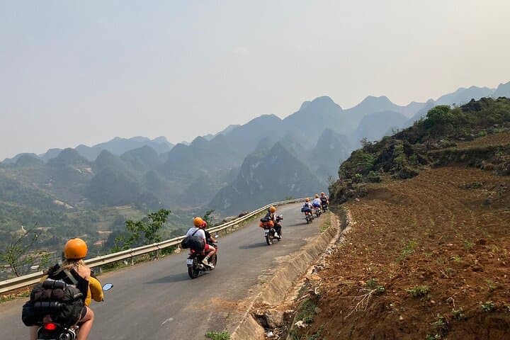


The road unspools out of Ha Giang city in a steady ribbon of asphalt, climbing through mist and terraced fields until limestone towers and wind-scoured ridges dominate the horizon. By the second morning the Quan Ba 'Heaven Gate' appears—a pair of twin cones standing like sentries above valleys where clouds slip low and the air tastes clean.
The road unspools out of Ha Giang city in a steady ribbon of asphalt, climbing through mist and terraced fields until limestone towers and wind-scoured ridges dominate the horizon. By the second morning the Quan Ba 'Heaven Gate' appears—a pair of twin cones standing like sentries above valleys where clouds slip low and the air tastes clean.
This five-day loop threads together the Dong Van stone plateau and Ma Pi Leng Pass, a 20 km stretch that clings to cliffs around 1,200 m elevation. The route traces millennia of geology: folded sedimentary layers carved into karst pinnacles and plateaus. Human history is equally visible — the Hmong King’s Palace, a wooden mansion from the early 20th century, and Lung Cu flagpole, a modern monument marking Vietnam’s northern edge after centuries of shifting frontiers.
Cultural encounters are part of the rhythm: short walks through Lo Lo Chai and Pa Vi villages, markets where brocade and river-fresh foods anchor daily life, and homestays that trade comfort for authentic evenings around shared meals.
Practical note: this tour is vehicle-led with short, guided walks; expect long drives between viewpoints and winding mountain roads. Bring layered clothing for cool mornings and sudden rain, sturdy shoes for village paths, and anti-nausea options if you’re sensitive to mountain passes. Timing your photography around sunrise and late afternoon delivers the best light and avoids mid-day haze.
For travelers seeking dramatic landscapes without motorbike logistics, the Ha Giang car loop pairs big views with manageable walking and direct cultural access—an efficient way to experience northern Vietnam’s highlands.