THE ADVENTURE COLLECTIVE® · Independent discovery and booking for outdoor travel

A fast-paced two-day circuit through Ha Giang’s rugged karst plateau, the loop links Ma Pi Leng pass, Meo Vac treks and Dong Van markets. Ideal for travelers who want concentrated exposure to northern Vietnam’s geology, ethnic culture and dramatic mountain roads.
A fast-paced two-day circuit through Ha Giang’s rugged karst plateau, the loop links Ma Pi Leng pass, Meo Vac treks and Dong Van markets. Ideal for travelers who want concentrated exposure to northern Vietnam’s geology, ethnic culture and dramatic mountain roads.
Morning light cuts across switchbacks as a small convoy climbs from Ha Giang City into a landscape that feels older than borders. Ragged limestone walls rise, terraces step down like pages of a slow-moving book, and the Nho Que River threads the valley below, daring travelers to peer over the pass.
Verified experiences and guided adventures in the surrounding area.
Operated by Mr Linh's Adventures · Ha Giang City, Ha Giang Province
Morning light cuts across switchbacks as a small convoy climbs from Ha Giang City into a landscape that feels older than borders. Ragged limestone walls rise, terraces step down like pages of a slow-moving book, and the Nho Que River threads the valley below, daring travelers to peer over the pass.
This compact two-day loop threads together the region’s most compelling chapters: the French-era bunkers near Quan Ba, the dramatic Ma Pi Leng ridge that exposes limestone karst and ancient river-cut canyons, and the market rhythms of Dong Van where H’mong, Lo Lo and Tay communities trade livestock and woven cloth. Geologically, the area is part of the Dong Van Karst Plateau—limestone sculpted into cliffs, stone plateaus, and deep gorges by millennia of water and tectonic lift.
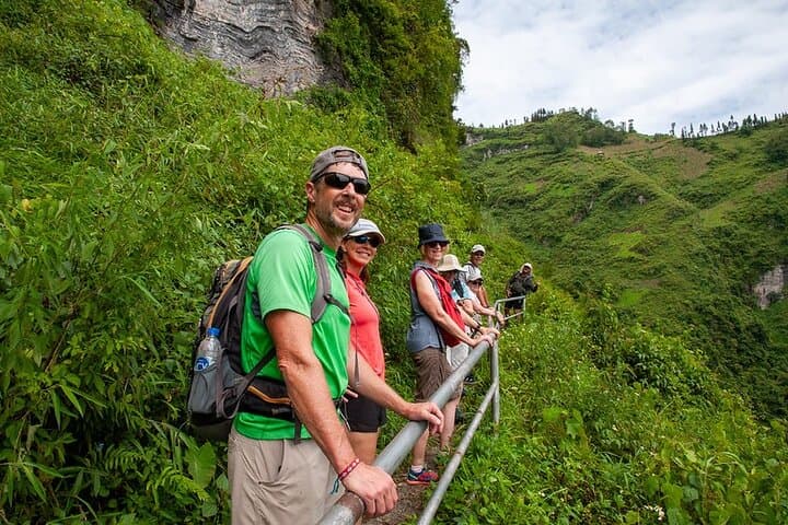
Culturally the route is intimate; homestays and small hotels introduce regional cuisine and ethnic customs. Guides trained on mountain roads handle the technical driving while brief hikes (8–10 km day one, 5–7 km day two) put travelers on exposed ridgelines and quiet valley trails. Expect uneven stone and dirt paths, steep ascents and descents, and viewpoints where wind pries sounds from the canyon.
Practically: travel light, sleep in Dong Van (hotel or homestay), and time visits to local Sunday markets for peak cultural exposure. Hydrate at altitude, wear grippy hiking shoes, and carry a waterproof layer—weather changes fast. For those short on time, the loop compresses remote northern Vietnam into two days without sacrificing the region’s core landscapes.
moderate.
2 days.
Suitable for travelers who can hike 8–10 km on uneven terrain and tolerate multiple hours in a vehicle; basic stamina and balance recommended.
Day one includes 8–10 km over mixed terrain with some steep sections; day two is shorter (5–7 km). Moderate fitness and steady balance are sufficient for most participants.
Transportation from Hanoi is available on request—organizers can arrange sleeper bus options, but confirm at booking.
Foreign travelers should check Vietnam visa requirements in advance; the tour includes necessary local travel permits for the loop.
Yes, but conditions vary: fall and spring offer the most stable weather; summer is rainy and winter can be cold with frost on the plateau.
The Dong Van Plateau has long been a crossroads of ethnic groups; French colonial roads and bunkers still mark strategic sites along the loop.
Visitor numbers are growing—stick to marked trails, avoid single-use plastics, and support local homestays to keep tourism benefits in the community.
Mr Linh's Adventures operates guided outdoor trips and adventures with an emphasis on safety, stewardship, and memorable experiences.
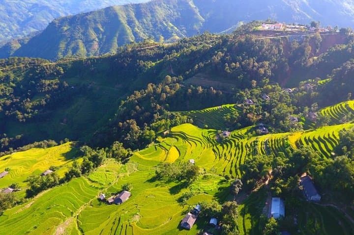


Morning light cuts across switchbacks as a small convoy climbs from Ha Giang City into a landscape that feels older than borders. Ragged limestone walls rise, terraces step down like pages of a slow-moving book, and the Nho Que River threads the valley below, daring travelers to peer over the pass.
Morning light cuts across switchbacks as a small convoy climbs from Ha Giang City into a landscape that feels older than borders. Ragged limestone walls rise, terraces step down like pages of a slow-moving book, and the Nho Que River threads the valley below, daring travelers to peer over the pass.
This compact two-day loop threads together the region’s most compelling chapters: the French-era bunkers near Quan Ba, the dramatic Ma Pi Leng ridge that exposes limestone karst and ancient river-cut canyons, and the market rhythms of Dong Van where H’mong, Lo Lo and Tay communities trade livestock and woven cloth. Geologically, the area is part of the Dong Van Karst Plateau—limestone sculpted into cliffs, stone plateaus, and deep gorges by millennia of water and tectonic lift.
Culturally the route is intimate; homestays and small hotels introduce regional cuisine and ethnic customs. Guides trained on mountain roads handle the technical driving while brief hikes (8–10 km day one, 5–7 km day two) put travelers on exposed ridgelines and quiet valley trails. Expect uneven stone and dirt paths, steep ascents and descents, and viewpoints where wind pries sounds from the canyon.
Practically: travel light, sleep in Dong Van (hotel or homestay), and time visits to local Sunday markets for peak cultural exposure. Hydrate at altitude, wear grippy hiking shoes, and carry a waterproof layer—weather changes fast. For those short on time, the loop compresses remote northern Vietnam into two days without sacrificing the region’s core landscapes.