THE ADVENTURE COLLECTIVE® · Independent discovery and booking for outdoor travel

A compact, three‑day loop from Quito that stitches together Quilotoa’s crater, Baños’ waterfall circuit and Cotopaxi’s alpine plains. Expect long drives, short hikes, rich culture and dramatic volcanic scenery.
A compact, three‑day loop from Quito that stitches together Quilotoa’s crater, Baños’ waterfall circuit and Cotopaxi’s alpine plains. Expect long drives, short hikes, rich culture and dramatic volcanic scenery.
You leave Quito before dawn and the city slowly thins into highland road — mist clings to pastures, tractors appear as silhouettes, and the Andes push the horizon into a jagged line. By mid-morning the bright, glassy bowl of Quilotoa appears: a crater lake that holds an almost unreal green, its rim winds offering exposed volcanic rock and a shutter‑clicking crowd. Later, Baños waits — a compact town wrapped around hot springs and framed by plunging waterfalls whose spray daringly reaches the roadside.
Verified experiences and guided adventures in the surrounding area.
Operated by GREEN ADVENTURES · Baños de Agua Santa, Tungurahua
You leave Quito before dawn and the city slowly thins into highland road — mist clings to pastures, tractors appear as silhouettes, and the Andes push the horizon into a jagged line. By mid-morning the bright, glassy bowl of Quilotoa appears: a crater lake that holds an almost unreal green, its rim winds offering exposed volcanic rock and a shutter‑clicking crowd. Later, Baños waits — a compact town wrapped around hot springs and framed by plunging waterfalls whose spray daringly reaches the roadside.
The route threads together volcanic geology and living Andean culture. Quilotoa is a collapsed caldera, shaped by eruptions centuries ago; Cotopaxi, at roughly 5,897 m, is one of the world’s highest active volcanoes and dominates its national park. Along the way you’ll pass traditional markets — Pujilí or Zumbahua when they run — and artisan villages like Tigua and Salasaca, where dyeing and weaving remain practical crafts and cultural markers.
Expect long driving stretches punctuated by short hikes: a steep descent into Quilotoa (mules optional for the climb back), a 45‑minute forest walk to Pailón del Diablo, and an easy circumnavigation of Limpiopungo Lake beneath Cotopaxi’s snow line. Practical notes: altitude and rapid weather shifts mean layered clothing, sun protection, and steady hydration are essential. National park fees are handled on the trip; guides provide local context and navigation. With moderate fitness you’ll move easily through the days, gaining both photos and an on-the-ground understanding of Ecuador’s Andean spine.
moderate.
3 days (approx. 8–10 hours/day including drives).
Moderate fitness: comfortable with multi‑hour hikes, stairs, and short steep climbs at altitude.
Yes — both Quilotoa and Cotopaxi sit at high elevations; drink water, move at a steady pace, and inform guides of any symptoms so they can adjust the itinerary.
National park fees are listed in the tour inclusions; if additional permits are required for specific activities your guide will advise in advance.
Yes — mule services are typically available at Quilotoa for the ascent; the cost is not included and is paid locally.
Yes — the tour includes hotel pickup and drop‑off within the Quito area; confirm your pickup point at booking.
The route crosses lands shaped by repeated volcanism and long‑standing indigenous trade routes; towns like Salasaca preserve weaving traditions introduced centuries ago.
Cotopaxi and surrounding reserves are protected areas with fragile páramo ecosystems—stick to trails, avoid feeding wildlife and follow guide instructions to reduce impact.
GREEN ADVENTURES operates guided outdoor trips and adventures with an emphasis on safety, stewardship, and memorable experiences.
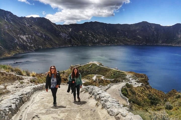
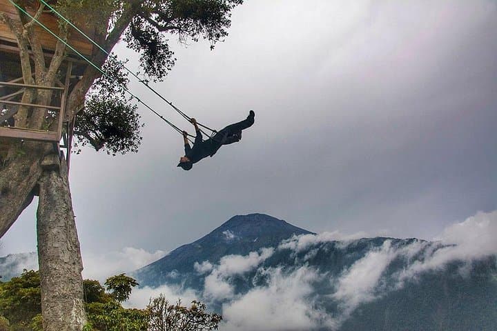
You leave Quito before dawn and the city slowly thins into highland road — mist clings to pastures, tractors appear as silhouettes, and the Andes push the horizon into a jagged line. By mid-morning the bright, glassy bowl of Quilotoa appears: a crater lake that holds an almost unreal green, its rim winds offering exposed volcanic rock and a shutter‑clicking crowd. Later, Baños waits — a compact town wrapped around hot springs and framed by plunging waterfalls whose spray daringly reaches the roadside.
You leave Quito before dawn and the city slowly thins into highland road — mist clings to pastures, tractors appear as silhouettes, and the Andes push the horizon into a jagged line. By mid-morning the bright, glassy bowl of Quilotoa appears: a crater lake that holds an almost unreal green, its rim winds offering exposed volcanic rock and a shutter‑clicking crowd. Later, Baños waits — a compact town wrapped around hot springs and framed by plunging waterfalls whose spray daringly reaches the roadside.
The route threads together volcanic geology and living Andean culture. Quilotoa is a collapsed caldera, shaped by eruptions centuries ago; Cotopaxi, at roughly 5,897 m, is one of the world’s highest active volcanoes and dominates its national park. Along the way you’ll pass traditional markets — Pujilí or Zumbahua when they run — and artisan villages like Tigua and Salasaca, where dyeing and weaving remain practical crafts and cultural markers.
Expect long driving stretches punctuated by short hikes: a steep descent into Quilotoa (mules optional for the climb back), a 45‑minute forest walk to Pailón del Diablo, and an easy circumnavigation of Limpiopungo Lake beneath Cotopaxi’s snow line. Practical notes: altitude and rapid weather shifts mean layered clothing, sun protection, and steady hydration are essential. National park fees are handled on the trip; guides provide local context and navigation. With moderate fitness you’ll move easily through the days, gaining both photos and an on-the-ground understanding of Ecuador’s Andean spine.