THE ADVENTURE COLLECTIVE® · Independent discovery and booking for outdoor travel

Walk Arles at your own pace with an offline app that guides you through Roman ruins, cloisters, and Van Gogh haunts. This 2–3 hour self-guided tour blends deep history with practical navigation for independent explorers.
Walk Arles at your own pace with an offline app that guides you through Roman ruins, cloisters, and Van Gogh haunts. This 2–3 hour self-guided tour blends deep history with practical navigation for independent explorers.
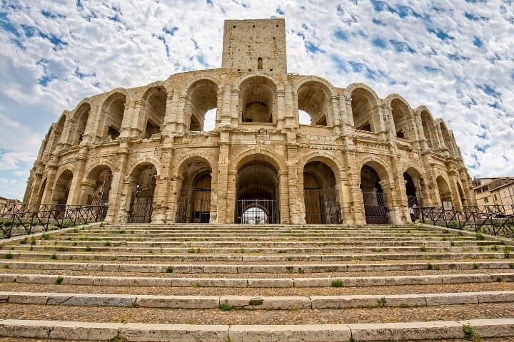
You step off the Rhône's river breeze into a square framed by honey-colored stone and the low murmur of conversation. The Roman Amphitheatre rises ahead—its arches like patient eyes watching centuries pass—while cobbled lanes thread outward toward cloisters, fountains, and hidden courtyards. This self-guided walking tour, delivered through a downloadable app and offline map, places the city's layers under your feet: Roman engineering, medieval ecclesiastical art, and the bright brushstrokes that drew Van Gogh to these streets.
Verified experiences and guided adventures in the surrounding area.
Operated by Trippy Tour Guide · Arles, Provence-Alpes-Côte d'Azur
You step off the Rhône's river breeze into a square framed by honey-colored stone and the low murmur of conversation. The Roman Amphitheatre rises ahead—its arches like patient eyes watching centuries pass—while cobbled lanes thread outward toward cloisters, fountains, and hidden courtyards. This self-guided walking tour, delivered through a downloadable app and offline map, places the city's layers under your feet: Roman engineering, medieval ecclesiastical art, and the bright brushstrokes that drew Van Gogh to these streets.
Arles grew on a Roman grid and prospered as a trading hub; the amphitheatre and the Alyscamps necropolis are tangible evidence of that imperial past. Geologically the town sits on Rhône alluvium, its flat plains giving way to the wetlands of the nearby Camargue—expect clay and cobble underfoot. Culturally, Arles balances Provençal markets, boulangeries, and active festivals that keep public squares lively year-round.
Practically, the app offers 20+ narration points, written guides, and a fully offline map so you can wander without data. Plan 2–3 hours to cover highlights at a relaxed pace; shorter if you skip side streets. Wear sturdy shoes for uneven cobbles, carry water, and factor in shade or a sun hat in summer. Morning or late afternoon light softens the stones and thins crowds. Respect protected monuments—many sites prohibit climbing and require quiet preservation. With an app in your pocket and a map in hand, Arles becomes a walkable museum where history is tangible and the city invites deliberate exploration.
easy.
2–3 hours.
Suitable for most fitness levels; requires steady walking on uneven surfaces for up to three hours
No—the tour includes a fully offline map and written narration so you can use it without mobile data once downloaded.
Many central streets are level but historic cobbles and occasional thresholds can be challenging; some sites have limited accessibility—contact local visitor services for specifics.
Expect 2–3 hours at a relaxed pace; shorter if you skip side streets or linger at fewer stops.
Access to interiors may require separate tickets or opening hours—this self-guided tour highlights exterior viewpoints and directions but does not include admission fees.
Arles was a major Roman port and administrative center; its amphitheatre and the Alyscamps reflect imperial burial and entertainment practices that shaped the city's urban fabric.
Many monuments are protected archaeological sites; stick to marked paths and avoid touching ancient stonework to help preserve fragile surfaces.
Trippy Tour Guide operates guided outdoor trips and adventures with an emphasis on safety, stewardship, and memorable experiences.
You step off the Rhône's river breeze into a square framed by honey-colored stone and the low murmur of conversation. The Roman Amphitheatre rises ahead—its arches like patient eyes watching centuries pass—while cobbled lanes thread outward toward cloisters, fountains, and hidden courtyards. This self-guided walking tour, delivered through a downloadable app and offline map, places the city's layers under your feet: Roman engineering, medieval ecclesiastical art, and the bright brushstrokes that drew Van Gogh to these streets.
You step off the Rhône's river breeze into a square framed by honey-colored stone and the low murmur of conversation. The Roman Amphitheatre rises ahead—its arches like patient eyes watching centuries pass—while cobbled lanes thread outward toward cloisters, fountains, and hidden courtyards. This self-guided walking tour, delivered through a downloadable app and offline map, places the city's layers under your feet: Roman engineering, medieval ecclesiastical art, and the bright brushstrokes that drew Van Gogh to these streets.
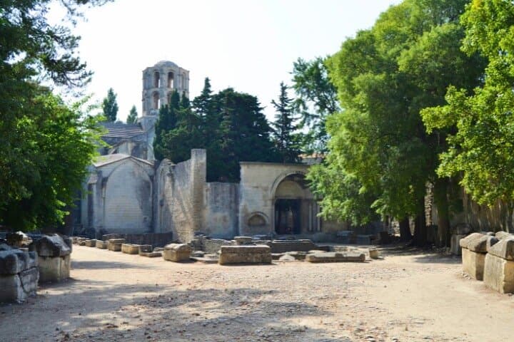
Arles grew on a Roman grid and prospered as a trading hub; the amphitheatre and the Alyscamps necropolis are tangible evidence of that imperial past. Geologically the town sits on Rhône alluvium, its flat plains giving way to the wetlands of the nearby Camargue—expect clay and cobble underfoot. Culturally, Arles balances Provençal markets, boulangeries, and active festivals that keep public squares lively year-round.
Practically, the app offers 20+ narration points, written guides, and a fully offline map so you can wander without data. Plan 2–3 hours to cover highlights at a relaxed pace; shorter if you skip side streets. Wear sturdy shoes for uneven cobbles, carry water, and factor in shade or a sun hat in summer. Morning or late afternoon light softens the stones and thins crowds. Respect protected monuments—many sites prohibit climbing and require quiet preservation. With an app in your pocket and a map in hand, Arles becomes a walkable museum where history is tangible and the city invites deliberate exploration.