THE ADVENTURE COLLECTIVE® · Independent discovery and booking for outdoor travel

A 17-day circuit linking Gokyo’s high lakes with the classic Everest Base Camp route. Expect high-altitude passes, teahouse nights, Sherpa culture and jaw-dropping Himalayan panoramas.
A 17-day circuit linking Gokyo’s high lakes with the classic Everest Base Camp route. Expect high-altitude passes, teahouse nights, Sherpa culture and jaw-dropping Himalayan panoramas.
You step off the light aircraft in Lukla and the valley breathes cold, thin air into your lungs — prayer flags flapping like bright punctuation against a skyline of serrated granite. Over the next two weeks the trail threads through rhododendron forests, Sherpa villages, moraine fields and glacier-polished rock as the Himalaya steadily rearranges the horizon into Everest, Lhotse, Cho Oyu and Gyachung Kang.
Verified experiences and guided adventures in the surrounding area.
Operated by Sunrise Adventure Trek P. Ltd · Namche Bazaar, Province No. 1
You step off the light aircraft in Lukla and the valley breathes cold, thin air into your lungs — prayer flags flapping like bright punctuation against a skyline of serrated granite. Over the next two weeks the trail threads through rhododendron forests, Sherpa villages, moraine fields and glacier-polished rock as the Himalaya steadily rearranges the horizon into Everest, Lhotse, Cho Oyu and Gyachung Kang.
This route combines two classic approaches: the high lakes of Gokyo, sitting at roughly 4,760 m, and the traditional Everest Base Camp corridor via Kongma La and Gorak Shep. Geologically the region is young, uplifted crust and active glaciation; you’ll cross moraines and the Cho La, where wind-scoured ice confronts you. Culturally the Khumbu is Sherpa land — monasteries like Tengboche frame views and offer a living connection to Tibetan Buddhism and Himalayan trade history.
Practically, expect long days of uphill walking with intermittent acclimatization stops in Namche and Dingboche. Lodging is basic teahouse style: shared rooms, hot meals, and wood or yak-dung heating. Weather shifts fast — clear mornings can go to spindrift and whiteouts by afternoon. Carry layers, hydrate deliberately, and plan for at least two nights above 4,500 m to adapt.
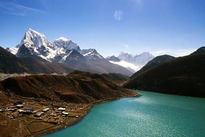
On the trail, keep cash for teahouses, respect local customs (remove hats in monasteries), and tread lightly on fragile alpine vegetation. With proper pacing and gear this 17-day circuit delivers skyline views of Everest from Kala Patthar and the mirrored blue of Gokyo that reward steady effort and altitude management.
challenging.
14–19 days.
Good aerobic fitness with prior multi-day hiking experience; ability to carry a daypack for 6–8 hour walks and tolerate high-altitude exertion.
Yes — TIMS card and Sagarmatha National Park permit are required and typically handled by your operator prior to departure.
Spring (March–May) and fall (September–November) offer the most stable weather and clearest mountain views; shoulder seasons are colder or wetter.
Cho La (approx. 5,420 m) is a technical high pass with steep approaches and possibly snow; it demands good fitness, steady footing and often basic crampon experience.
Teahouses provide basic twin rooms, shared facilities, and hot meals; elevate expectations for luxury but accept local hospitality and warm food.
The Khumbu valley is historically a trade corridor between Tibet and Nepal; Sherpa villages grew around trade, yak pastoralism and Himalayan exploration starting in the early 20th century.
Sagarmatha National Park manages visitor impact with permit fees; stick to trails, pack out waste where possible and minimize single-use plastics to protect fragile alpine ecosystems.
Sunrise Adventure Trek P. Ltd operates guided outdoor trips and adventures with an emphasis on safety, stewardship, and memorable experiences.
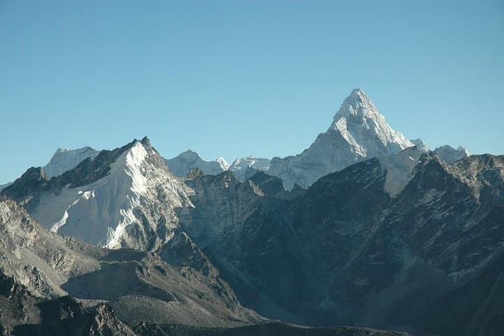
You step off the light aircraft in Lukla and the valley breathes cold, thin air into your lungs — prayer flags flapping like bright punctuation against a skyline of serrated granite. Over the next two weeks the trail threads through rhododendron forests, Sherpa villages, moraine fields and glacier-polished rock as the Himalaya steadily rearranges the horizon into Everest, Lhotse, Cho Oyu and Gyachung Kang.
You step off the light aircraft in Lukla and the valley breathes cold, thin air into your lungs — prayer flags flapping like bright punctuation against a skyline of serrated granite. Over the next two weeks the trail threads through rhododendron forests, Sherpa villages, moraine fields and glacier-polished rock as the Himalaya steadily rearranges the horizon into Everest, Lhotse, Cho Oyu and Gyachung Kang.
This route combines two classic approaches: the high lakes of Gokyo, sitting at roughly 4,760 m, and the traditional Everest Base Camp corridor via Kongma La and Gorak Shep. Geologically the region is young, uplifted crust and active glaciation; you’ll cross moraines and the Cho La, where wind-scoured ice confronts you. Culturally the Khumbu is Sherpa land — monasteries like Tengboche frame views and offer a living connection to Tibetan Buddhism and Himalayan trade history.
Practically, expect long days of uphill walking with intermittent acclimatization stops in Namche and Dingboche. Lodging is basic teahouse style: shared rooms, hot meals, and wood or yak-dung heating. Weather shifts fast — clear mornings can go to spindrift and whiteouts by afternoon. Carry layers, hydrate deliberately, and plan for at least two nights above 4,500 m to adapt.
On the trail, keep cash for teahouses, respect local customs (remove hats in monasteries), and tread lightly on fragile alpine vegetation. With proper pacing and gear this 17-day circuit delivers skyline views of Everest from Kala Patthar and the mirrored blue of Gokyo that reward steady effort and altitude management.