THE ADVENTURE COLLECTIVE® · Independent discovery and booking for outdoor travel

A quick ferry ride from downtown Auckland delivers sweeping harbour skyline views, two volcanic cones with military and Māori history, and heritage streets lined in kauri timber. The 75-minute Devonport Explorer is a compact taste of Auckland’s geology and culture.
A quick ferry ride from downtown Auckland delivers sweeping harbour skyline views, two volcanic cones with military and Māori history, and heritage streets lined in kauri timber. The 75-minute Devonport Explorer is a compact taste of Auckland’s geology and culture.
The ferry slips free from downtown Auckland and, within 15 minutes, the skyline loosens into a panorama — cranes, glass towers and the white sweep of the Harbour Bridge give way to a quieter shoreline. You step off at Devonport and immediately feel the town’s two moods: the tidy civic calm of a seaside village and the slow gravity of old volcanic cones that shape the land and the view.
Verified experiences and guided adventures in the surrounding area.
The ferry slips free from downtown Auckland and, within 15 minutes, the skyline loosens into a panorama — cranes, glass towers and the white sweep of the Harbour Bridge give way to a quieter shoreline. You step off at Devonport and immediately feel the town’s two moods: the tidy civic calm of a seaside village and the slow gravity of old volcanic cones that shape the land and the view.
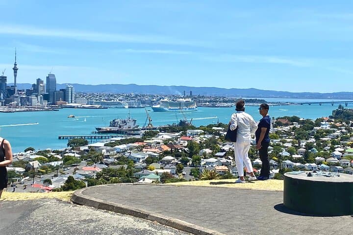
Climb the paved switchbacks toward Takarunga / Mount Victoria and the city contracts into a postcard of roofs and water. The route up is short — roughly 0.5–0.8 km with an elevation change of about 60–100 m — but the payoff is disproportionate: 360-degree vantage points where the harbour’s currents seem to pull your attention toward Rangitoto and the high-rise fringe. A few minutes further along, Maungauika / North Head opens onto WWII gun emplacements, tunnels and wider shoreline vistas. These two cones are more than viewpoints; they are layered histories — Māori pa sites reworked by colonial defence systems, and now public reserves framed by pōhutukawa.
Devonport’s streets are a study in timber and time. Heritage homes built from local kauri timber flank boutique cafes and the Torpedo Bay Navy Museum, where naval artifacts and local stories thread European settlement into Māori histories of the Waitematā. Geologically, the cones are part of Auckland’s monogenetic volcanic field: each eruption left a distinct bowl, tuff ring or crater, and the walking routes trace these surfaces, giving a tactile sense of deep, episodic heat beneath an otherwise green suburban surface.
Practical travelers can see most highlights in a 75-minute shore excursion, but timing is everything. Take an early ferry to avoid midday crowds on the peaks and to catch clearer air for skyline photography. The terrain is compact and mostly paved or well-graded track; sturdy walking shoes with a bit of tread are sufficient. Carry a light layer — coastal winds can turn cool — plus water, sunscreen, and a small pack for cameras and souvenirs. If you want to linger at a café or explore the Navy Museum, add an hour.
Local insight: stroll Cheltenham Beach for a quieter shoreline view after the cones, and check out the small shops along Victoria Road for locally made ceramics and coffee. Respect the historic military sites by following signposted paths and keeping to marked tunnels and lookout points. Leave no trace: the coastal reserves are sensitive to erosion and invasive weeds, so stick to trails and take any rubbish back to town.
For the traveler with a short window in Auckland, the Devonport Explorer delivers compact geology, layered history and harbour-side charm in a single, walkable experience that feels both immediate and enduring.
moderate.
1–1.5 hours.
Suitable for people with basic fitness; involves short uphill walking and stairs.
The typical public ferry crossing takes about 12–15 minutes each way from the Auckland CBD to Devonport Wharf.
The tour visits Takarunga / Mount Victoria and Maungauika / North Head — two of Devonport’s prominent volcanic cones with lookout points and historic features.
Yes — the walks are short but include some steep sections and stairs; most active children and mobile older adults can manage it with rests.
Yes; the museum is on the waterfront near the ferry terminal and can be included if you allow extra time beyond the standard 75-minute tour.
Tunnels and gun emplacements are typically open to the public on marked paths; follow signage and avoid entering any restricted areas for safety.
Advance booking isn’t always required for the ferry, but check schedules and make reservations during peak tourist season or for tight time windows.
The cones at Devonport were originally Māori pā sites and later refortified by colonial and WWII defenses; many streets show 19th-century kauri-built architecture.
Coastal reserves are sensitive to erosion and invasive plants—stay on tracks and dispose of rubbish in town bins to protect native vegetation.
The ferry slips free from downtown Auckland and, within 15 minutes, the skyline loosens into a panorama — cranes, glass towers and the white sweep of the Harbour Bridge give way to a quieter shoreline. You step off at Devonport and immediately feel the town’s two moods: the tidy civic calm of a seaside village and the slow gravity of old volcanic cones that shape the land and the view.
The ferry slips free from downtown Auckland and, within 15 minutes, the skyline loosens into a panorama — cranes, glass towers and the white sweep of the Harbour Bridge give way to a quieter shoreline. You step off at Devonport and immediately feel the town’s two moods: the tidy civic calm of a seaside village and the slow gravity of old volcanic cones that shape the land and the view.
Climb the paved switchbacks toward Takarunga / Mount Victoria and the city contracts into a postcard of roofs and water. The route up is short — roughly 0.5–0.8 km with an elevation change of about 60–100 m — but the payoff is disproportionate: 360-degree vantage points where the harbour’s currents seem to pull your attention toward Rangitoto and the high-rise fringe. A few minutes further along, Maungauika / North Head opens onto WWII gun emplacements, tunnels and wider shoreline vistas. These two cones are more than viewpoints; they are layered histories — Māori pa sites reworked by colonial defence systems, and now public reserves framed by pōhutukawa.
Devonport’s streets are a study in timber and time. Heritage homes built from local kauri timber flank boutique cafes and the Torpedo Bay Navy Museum, where naval artifacts and local stories thread European settlement into Māori histories of the Waitematā. Geologically, the cones are part of Auckland’s monogenetic volcanic field: each eruption left a distinct bowl, tuff ring or crater, and the walking routes trace these surfaces, giving a tactile sense of deep, episodic heat beneath an otherwise green suburban surface.
Practical travelers can see most highlights in a 75-minute shore excursion, but timing is everything. Take an early ferry to avoid midday crowds on the peaks and to catch clearer air for skyline photography. The terrain is compact and mostly paved or well-graded track; sturdy walking shoes with a bit of tread are sufficient. Carry a light layer — coastal winds can turn cool — plus water, sunscreen, and a small pack for cameras and souvenirs. If you want to linger at a café or explore the Navy Museum, add an hour.
Local insight: stroll Cheltenham Beach for a quieter shoreline view after the cones, and check out the small shops along Victoria Road for locally made ceramics and coffee. Respect the historic military sites by following signposted paths and keeping to marked tunnels and lookout points. Leave no trace: the coastal reserves are sensitive to erosion and invasive weeds, so stick to trails and take any rubbish back to town.
For the traveler with a short window in Auckland, the Devonport Explorer delivers compact geology, layered history and harbour-side charm in a single, walkable experience that feels both immediate and enduring.