THE ADVENTURE COLLECTIVE® · Independent discovery and booking for outdoor travel

A compact 2-day route from Quito that hits Cotopaxi National Park, the Quilotoa crater lake, and the thermal valley of Baños — dramatic geology, highland culture, and practical tips for acclimatizing and packing light.
A compact 2-day route from Quito that hits Cotopaxi National Park, the Quilotoa crater lake, and the thermal valley of Baños — dramatic geology, highland culture, and practical tips for acclimatizing and packing light.
A cold wind from the páramo meets the minibus as it climbs toward Cotopaxi’s crater, and for a moment the summit seems close enough to touch. Travelers step onto volcanic gravel; the air is thin and hard, and the volcano watches with a silent, snow-capped stare. This two-day, one-night route threads classic highland landscapes — an active national park, a cobalt crater lake, and the greener, steamy valley at Baños — giving a compact portrait of Andean Ecuador.
Verified experiences and guided adventures in the surrounding area.
A cold wind from the páramo meets the minibus as it climbs toward Cotopaxi’s crater, and for a moment the summit seems close enough to touch. Travelers step onto volcanic gravel; the air is thin and hard, and the volcano watches with a silent, snow-capped stare. This two-day, one-night route threads classic highland landscapes — an active national park, a cobalt crater lake, and the greener, steamy valley at Baños — giving a compact portrait of Andean Ecuador.
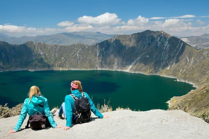
Geology here is immediate: Cotopaxi (5,897 m) is an ash-and-ice cone carved by eruptions and glaciers. Quilotoa’s 3,914 m crater rim circles a 3-km wide lake that filled a collapsed volcano; its green-blue water tests your camera settings. Baños sits lower (≈1,820 m), where volcanic springs and waterfalls carved a different kind of terrain and a culture tied to thermal baths and adventure sports.
Local communities keep highland markets, Tigua painters, and traditional quechua influences alive; roadside stalls sell mote and llapingachos that ground the trip in flavor. Expect switching microclimates — wind and sun at the rim, drizzle around Quilotoa, humid warmth in Baños.
Practical guidance: plan for altitude — take it slow, hydrate, and carry layers for wind and rain. Driving segments total several hours; bring snacks and a charged phone for photos. Footpaths at Quilotoa are steep with loose rock and simple switchbacks; Cotopaxi viewpoints require short hikes on volcanic scree. Schedule the early morning for crater light and late afternoon in Baños for waterfalls and hot springs. This loop is accessible without technical climbing gear but demands respect for elevation and weather.
moderate.
2 days (approx. 48 hours).
Good aerobic fitness for walking at high elevation and standing on steep trails; comfortable with 2–4 hour hikes.
No technical climbing skills are required; the tour uses trails and viewpoints. However, some short steep sections and uneven ground demand steady footing.
Cotopaxi and Quilotoa sit above 3,900 m; expect thinner air and colder temps — acclimatize, hydrate, and avoid heavy exertion on day one.
Inclusions vary by operator; typically the tour covers transport and a basic overnight stay, but confirm meals and hotel class when booking.
The route runs year-round, but weather varies: the dry season (June–Aug) offers clearer views while the wet season brings mud and limited visibility.
The highland route traces pre-Columbian paths and colonial-era market towns; local communities retain Quechua traditions and artisan crafts.
Cotopaxi National Park is protected but fragile — stick to trails, avoid feeding wildlife, and support locally run community projects when possible.
A cold wind from the páramo meets the minibus as it climbs toward Cotopaxi’s crater, and for a moment the summit seems close enough to touch. Travelers step onto volcanic gravel; the air is thin and hard, and the volcano watches with a silent, snow-capped stare. This two-day, one-night route threads classic highland landscapes — an active national park, a cobalt crater lake, and the greener, steamy valley at Baños — giving a compact portrait of Andean Ecuador.
A cold wind from the páramo meets the minibus as it climbs toward Cotopaxi’s crater, and for a moment the summit seems close enough to touch. Travelers step onto volcanic gravel; the air is thin and hard, and the volcano watches with a silent, snow-capped stare. This two-day, one-night route threads classic highland landscapes — an active national park, a cobalt crater lake, and the greener, steamy valley at Baños — giving a compact portrait of Andean Ecuador.
Geology here is immediate: Cotopaxi (5,897 m) is an ash-and-ice cone carved by eruptions and glaciers. Quilotoa’s 3,914 m crater rim circles a 3-km wide lake that filled a collapsed volcano; its green-blue water tests your camera settings. Baños sits lower (≈1,820 m), where volcanic springs and waterfalls carved a different kind of terrain and a culture tied to thermal baths and adventure sports.
Local communities keep highland markets, Tigua painters, and traditional quechua influences alive; roadside stalls sell mote and llapingachos that ground the trip in flavor. Expect switching microclimates — wind and sun at the rim, drizzle around Quilotoa, humid warmth in Baños.
Practical guidance: plan for altitude — take it slow, hydrate, and carry layers for wind and rain. Driving segments total several hours; bring snacks and a charged phone for photos. Footpaths at Quilotoa are steep with loose rock and simple switchbacks; Cotopaxi viewpoints require short hikes on volcanic scree. Schedule the early morning for crater light and late afternoon in Baños for waterfalls and hot springs. This loop is accessible without technical climbing gear but demands respect for elevation and weather.