THE ADVENTURE COLLECTIVE® · Independent discovery and booking for outdoor travel

A ready-to-use, web-based 183-mile road trip plan through 20 classic Cotswolds destinations. Pick sections for 3–14 days, follow pre-loaded Google Maps pins, and explore market towns, villages, and country estates at your own pace.
A ready-to-use, web-based 183-mile road trip plan through 20 classic Cotswolds destinations. Pick sections for 3–14 days, follow pre-loaded Google Maps pins, and explore market towns, villages, and country estates at your own pace.
Drive out of the town and the honey-coloured walls of a Cotswold village lean in close: low stone bridges, clipped hedgerows, and lanes that insist you slow down. This online self-guided road trip plan lays out 183 miles (292 km) of point-to-point driving across 20 classic destinations, split into five manageable sections so you can pick 3 days or stretch to 14.
Verified experiences and guided adventures in the surrounding area.
Operated by Uncover Britain Road Trips · Moreton-in-Marsh, Gloucestershire
Drive out of the town and the honey-coloured walls of a Cotswold village lean in close: low stone bridges, clipped hedgerows, and lanes that insist you slow down. This online self-guided road trip plan lays out 183 miles (292 km) of point-to-point driving across 20 classic destinations, split into five manageable sections so you can pick 3 days or stretch to 14.
The route threads through market towns and medieval villages shaped by the oolitic limestone that gives the region its warm hue. The plan highlights Bourton-on-the-Water’s shallow River Windrush crossings, Bibury’s Arlington Row cottages, Castle Combe’s medieval street plan, and market squares at Stow-on-the-Wold and Moreton-in-Marsh. Cultural notes orient you in the region’s wool-trade history and Arts & Crafts architecture while pointing to country estates like Blenheim Palace and small archaeological sites from Neolithic to Iron Age.
Practically, the guide is delivered via a web-based interface with pre-populated Google Maps pins and section-by-section routes for navigation on smartphone or tablet. Expect narrow B-roads, staggered parking at village centers, and short walks to viewpoints or tea rooms. Accessibility info is included and the plan is suitable for all fitness levels—its focus is driving and local exploration rather than long-distance hiking.
For planning: allow extra time for markets, seasonal crowds, and single-track lanes; fuel and phone signal can be intermittent on hillier stretches. Use the guide to build a realistic daily loop, book popular inns in advance, and layer a weatherproof jacket over comfortable walking shoes for the many short, rewarding strolls.
easy.
3–14 days.
Suitable for travelers in normal day-to-day fitness; most exploring involves short walks under 2 miles.
One account licence provides 12 months access to the online plan so you can prepare and use it while traveling.
Most roads are standard country lanes; larger vehicles may find some single-track sections tight—plan routes by section and check local restrictions.
The guide itself is not editable, but each section links to Google Maps so you can save and adapt routes to your preferences.
Yes—several market towns like Moreton-in-Marsh and Cheltenham are served by trains; combine rail with local buses or taxis for car-free sections.
The Cotswolds grew wealthy on the medieval wool trade; its golden oolitic limestone was quarried and used to build the villages you’ll visit.
Much of the area sits within the Cotswolds AONB; stick to paths, take litter home, and avoid parking on verges to protect fragile habitats.
Uncover Britain Road Trips operates guided outdoor trips and adventures with an emphasis on safety, stewardship, and memorable experiences.
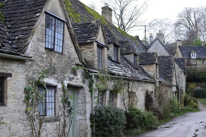



Drive out of the town and the honey-coloured walls of a Cotswold village lean in close: low stone bridges, clipped hedgerows, and lanes that insist you slow down. This online self-guided road trip plan lays out 183 miles (292 km) of point-to-point driving across 20 classic destinations, split into five manageable sections so you can pick 3 days or stretch to 14.
Drive out of the town and the honey-coloured walls of a Cotswold village lean in close: low stone bridges, clipped hedgerows, and lanes that insist you slow down. This online self-guided road trip plan lays out 183 miles (292 km) of point-to-point driving across 20 classic destinations, split into five manageable sections so you can pick 3 days or stretch to 14.
The route threads through market towns and medieval villages shaped by the oolitic limestone that gives the region its warm hue. The plan highlights Bourton-on-the-Water’s shallow River Windrush crossings, Bibury’s Arlington Row cottages, Castle Combe’s medieval street plan, and market squares at Stow-on-the-Wold and Moreton-in-Marsh. Cultural notes orient you in the region’s wool-trade history and Arts & Crafts architecture while pointing to country estates like Blenheim Palace and small archaeological sites from Neolithic to Iron Age.
Practically, the guide is delivered via a web-based interface with pre-populated Google Maps pins and section-by-section routes for navigation on smartphone or tablet. Expect narrow B-roads, staggered parking at village centers, and short walks to viewpoints or tea rooms. Accessibility info is included and the plan is suitable for all fitness levels—its focus is driving and local exploration rather than long-distance hiking.
For planning: allow extra time for markets, seasonal crowds, and single-track lanes; fuel and phone signal can be intermittent on hillier stretches. Use the guide to build a realistic daily loop, book popular inns in advance, and layer a weatherproof jacket over comfortable walking shoes for the many short, rewarding strolls.