THE ADVENTURE COLLECTIVE® · Independent discovery and booking for outdoor travel

Turn Charleston’s historic streets into a puzzle: this app-led scavenger hunt guides you through 10+ landmarks at your own pace. Expect 1.5–2 hours of walking, family-friendly riddles, and lots of photo stops along Rainbow Row and the waterfront.
Turn Charleston’s historic streets into a puzzle: this app-led scavenger hunt guides you through 10+ landmarks at your own pace. Expect 1.5–2 hours of walking, family-friendly riddles, and lots of photo stops along Rainbow Row and the waterfront.
You step off Broad Street and the city opens like a map waiting to be read: brick alleys, ironwork, and the harbor breeze pulling you toward the water. The scavenger hunt moves you through Marion Square, past the low pastel houses on Rainbow Row, and into the City Market where voices and vendors punctuate the route. Each clue sends you deeper into narrow streets, turning sightseeing into a compact urban expedition.
Verified experiences and guided adventures in the surrounding area.
Operated by World City Trail · Charleston, South Carolina
You step off Broad Street and the city opens like a map waiting to be read: brick alleys, ironwork, and the harbor breeze pulling you toward the water. The scavenger hunt moves you through Marion Square, past the low pastel houses on Rainbow Row, and into the City Market where voices and vendors punctuate the route. Each clue sends you deeper into narrow streets, turning sightseeing into a compact urban expedition.
Charleston’s built landscape is layered—colonial port, Civil War-era fortifications, and 19th-century mercantile wealth. The masonry and tabby foundations tell of tidal creeks that once ferried rice and indigo; museums along the route preserve stories from Gullah culture to maritime trade. Geology is subtle here—low coastal plain, marshes shaping the waterfront and the city’s grid.
Local rhythms matter: lunch at a market stall, a pause at Waterfront Park’s fountains, and quiet corners where oak roots press through old sidewalks. The app-driven format hands you clues instead of a guide, encouraging observation and conversation as the main equipment.
Practical guide: plan for about 1.5–2 hours walking (3 km total walking distance with 43 minutes of active walking), bring a charged phone with data for the World City Trail app, and wear comfortable shoes for uneven pavement and cobbles. Start early to avoid midday heat in summer and allow flexibility—this is self-guided, so you can linger at a museum or return later. Keep water handy, use sunscreen near the waterfront, and respect signs if you choose to enter paid sites—the puzzles focus on outdoor areas, so entrance fees are optional.
easy.
1.5–2 hours.
Suitable for most fitness levels; requires basic walking stamina for a few kilometers and standing for photo/puzzle stops.
No — this is self-guided. Use the World City Trail app and your booking reference to choose your start time and location.
No — the puzzles focus on outdoor areas; entering museums or paid sites is optional and may have separate fees.
Yes — puzzles are family-friendly and the route is flexible, though very large groups should split into teams for a better experience.
You can pause and resume later; the app saves progress and you can continue another day within the booking window.
Charleston grew as a colonial port and later an antebellum commercial hub; the downtown grid preserves architecture from the 18th and 19th centuries tied to maritime trade and Gullah culture.
Visit with low-impact practices—use refillable water, stay on public paths, and support museums and local businesses to fund preservation of historic sites.
World City Trail operates guided outdoor trips and adventures with an emphasis on safety, stewardship, and memorable experiences.

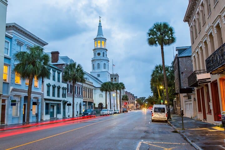


You step off Broad Street and the city opens like a map waiting to be read: brick alleys, ironwork, and the harbor breeze pulling you toward the water. The scavenger hunt moves you through Marion Square, past the low pastel houses on Rainbow Row, and into the City Market where voices and vendors punctuate the route. Each clue sends you deeper into narrow streets, turning sightseeing into a compact urban expedition.
You step off Broad Street and the city opens like a map waiting to be read: brick alleys, ironwork, and the harbor breeze pulling you toward the water. The scavenger hunt moves you through Marion Square, past the low pastel houses on Rainbow Row, and into the City Market where voices and vendors punctuate the route. Each clue sends you deeper into narrow streets, turning sightseeing into a compact urban expedition.
Charleston’s built landscape is layered—colonial port, Civil War-era fortifications, and 19th-century mercantile wealth. The masonry and tabby foundations tell of tidal creeks that once ferried rice and indigo; museums along the route preserve stories from Gullah culture to maritime trade. Geology is subtle here—low coastal plain, marshes shaping the waterfront and the city’s grid.
Local rhythms matter: lunch at a market stall, a pause at Waterfront Park’s fountains, and quiet corners where oak roots press through old sidewalks. The app-driven format hands you clues instead of a guide, encouraging observation and conversation as the main equipment.
Practical guide: plan for about 1.5–2 hours walking (3 km total walking distance with 43 minutes of active walking), bring a charged phone with data for the World City Trail app, and wear comfortable shoes for uneven pavement and cobbles. Start early to avoid midday heat in summer and allow flexibility—this is self-guided, so you can linger at a museum or return later. Keep water handy, use sunscreen near the waterfront, and respect signs if you choose to enter paid sites—the puzzles focus on outdoor areas, so entrance fees are optional.