THE ADVENTURE COLLECTIVE® · Independent discovery and booking for outdoor travel

A two-day guided climb to the 5,790 m summit of Cayambe mixes a high-altitude refuge night with a pre-dawn glacier ascent. Expect long days, crampon-and-axe travel, and sweeping views toward the Amazonian basin.
A two-day guided climb to the 5,790 m summit of Cayambe mixes a high-altitude refuge night with a pre-dawn glacier ascent. Expect long days, crampon-and-axe travel, and sweeping views toward the Amazonian basin.
Night in the refuge, wind rattling the corrugated roof, and a hush that only high mountains know — that’s the opening chapter of a Cayambe summit attempt. Drive north from Quito for roughly two hours to 4,400–4,600 m, then hike to the refuge where guides kit you out for glacier travel and you sleep with the peak’s shadow filling the window.
Verified experiences and guided adventures in the surrounding area.
Operated by CarpeDM Adventures · Cayambe, Pichincha
Night in the refuge, wind rattling the corrugated roof, and a hush that only high mountains know — that’s the opening chapter of a Cayambe summit attempt. Drive north from Quito for roughly two hours to 4,400–4,600 m, then hike to the refuge where guides kit you out for glacier travel and you sleep with the peak’s shadow filling the window.
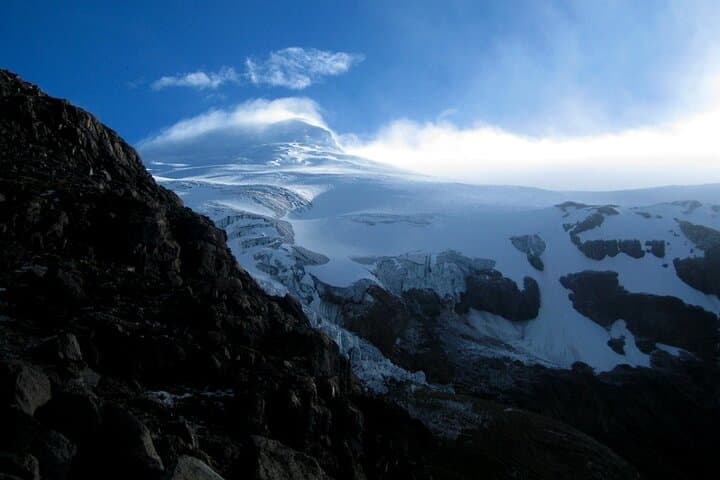
Cayambe is an extinct, ice-crowned volcano rising to 5,790 m and is uniquely the highest point on the Equator line. The massif sits inside the Cayambe Coca Reserve; its crevassed glaciers and volcanic rock tell a geologic story of uplift, glaciation and frequent weather swings. Local Kichwa communities have long regarded these high places with cultural significance, and modern ascents follow routes that balance safety with respect for fragile páramo above 4,000 m.
Practically: the itinerary is two days. Day one: drive (~2 hours), hike to refuge at ~4,600 m, glacier practice. Day two: wake around midnight, move by ~1:00 am, scramble then rope-up on ice — expect 4–6 hours to the summit and 2–3 hours back to the refuge before returning to Quito.
Prepare for wind, sudden snow and thin air. Use layered insulation, sturdy mountaineering boots, and learn basic crampon and ice-axe techniques before you go. Hydrate, pace yourself on the ascent, and plan for only brief summit time due to exposure. For climbers comfortable above 4,000 m seeking a technically approachable but altitude-demanding goal, Cayambe delivers sharp views toward the Amazonian flank and an honest high-Andes experience.
challenging.
2 days (12–16 hours active).
Participants should have excellent aerobic fitness, experience with sustained uphill hiking, and prior high-altitude exposure if possible.
Technically the route is moderate: steep rock and glacier travel require crampons, ice axe and roped travel, but certified guides lead rope teams and provide instruction.
Prior high-altitude hiking and basic familiarity with crampons and ice axe use are strongly recommended; complete novices should consider a skills course first.
The drier months (roughly June–September) offer more stable weather and clearer summit windows; shoulder months can be unpredictable with increased storms.
Acute mountain sickness is a real risk above 4,000 m; acclimatize before the climb, ascend slowly, stay hydrated and notify guides immediately if symptoms appear.
Cayambe has long cultural importance for Kichwa communities and is noted in records as the highest ice cap directly on the Equator line.
The Cayambe-Coca reserve protects fragile páramo and glacial systems—stick to trails, pack out waste, and minimize campfire or campsite impact.
CarpeDM Adventures operates guided outdoor trips and adventures with an emphasis on safety, stewardship, and memorable experiences.
Night in the refuge, wind rattling the corrugated roof, and a hush that only high mountains know — that’s the opening chapter of a Cayambe summit attempt. Drive north from Quito for roughly two hours to 4,400–4,600 m, then hike to the refuge where guides kit you out for glacier travel and you sleep with the peak’s shadow filling the window.
Night in the refuge, wind rattling the corrugated roof, and a hush that only high mountains know — that’s the opening chapter of a Cayambe summit attempt. Drive north from Quito for roughly two hours to 4,400–4,600 m, then hike to the refuge where guides kit you out for glacier travel and you sleep with the peak’s shadow filling the window.
Cayambe is an extinct, ice-crowned volcano rising to 5,790 m and is uniquely the highest point on the Equator line. The massif sits inside the Cayambe Coca Reserve; its crevassed glaciers and volcanic rock tell a geologic story of uplift, glaciation and frequent weather swings. Local Kichwa communities have long regarded these high places with cultural significance, and modern ascents follow routes that balance safety with respect for fragile páramo above 4,000 m.
Practically: the itinerary is two days. Day one: drive (~2 hours), hike to refuge at ~4,600 m, glacier practice. Day two: wake around midnight, move by ~1:00 am, scramble then rope-up on ice — expect 4–6 hours to the summit and 2–3 hours back to the refuge before returning to Quito.
Prepare for wind, sudden snow and thin air. Use layered insulation, sturdy mountaineering boots, and learn basic crampon and ice-axe techniques before you go. Hydrate, pace yourself on the ascent, and plan for only brief summit time due to exposure. For climbers comfortable above 4,000 m seeking a technically approachable but altitude-demanding goal, Cayambe delivers sharp views toward the Amazonian flank and an honest high-Andes experience.