
Bay of Fundy Smartphone Audio Driving Tour: Moncton to St. Martins
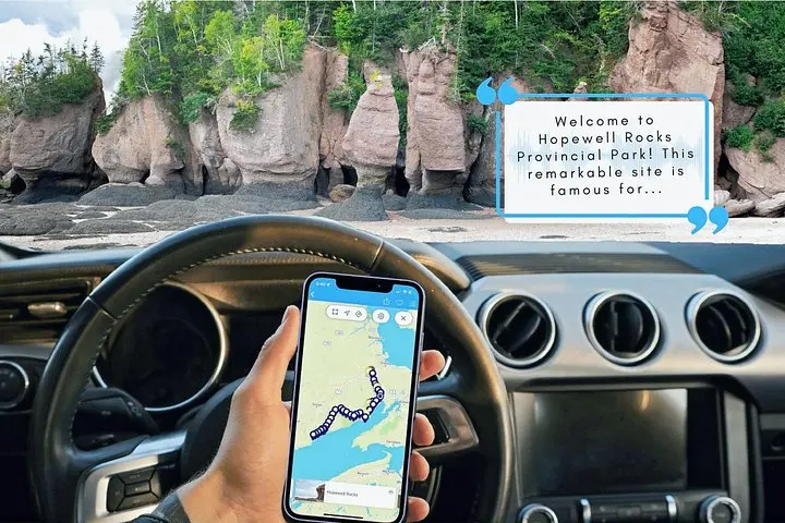
Drive along one of the planet’s most extreme coastlines with an offline smartphone audio guide. From Moncton to St. Martins, learn geology, local history and best places to stop while syncing narration to your GPS.
An Adventure In Moncton.
Drive along one of the planet’s most extreme coastlines with an offline smartphone audio guide. From Moncton to St. Martins, learn geology, local history and best places to stop while syncing narration to your GPS.
Read the full experience
You pull out of Moncton as the road loosens its grip on the city. Salt air finds its way through open windows and the highway bends toward a coastline governed by the world’s highest tides. The audio guide pings where the map says to look; a voice—sometimes a historian, sometimes a character from the past—frames cliffs, lighthouse keepers and the gull-haunted beaches ahead.
You pull out of Moncton as the road loosens its grip on the city. Salt air finds its way through open windows and the highway bends toward a coastline governed by the world’s highest tides. The audio guide pings where the map says to look; a voice—sometimes a historian, sometimes a character from the past—frames cliffs, lighthouse keepers and the gull-haunted beaches ahead.
Geology here reads like a slow, relentless clock. The Bay of Fundy’s cliffs and sea caves are carved by tidal ranges that exceed 16 metres, exposing red sandstone, fossil-rich cliffs and vast mudflats at low tide. Indigenous Mi'kmaq and early European settlers shaped the coastline’s culture—fishing communities, shipbuilding yards and lighthouse lore thread the towns you pass.
The route crosses Stonehammer UNESCO Global Geopark, threads Fundy National Park and finishes at St. Martins’ sea caves. Expect stop suggestions for short boardwalks, lookouts and beaches; some park stops require permits or small fees. Wildlife is active at the shoreline—shorebirds, seals and raptors are common sights, particularly at low tide or during migration.
Practical guidance: download the tour ahead of time and mount your phone; the app runs offline after the initial download. Allow three hours minimum if you plan a quick walk at one or two lookouts; add more time for park trails or tide-dependent cave access. Fuel up, check tide tables if you want to walk the low-tide flats, and bring layers—the coastline can be windy and cool even on warm days. This is a relaxed, vehicle-based way to put the Fundy’s wild edge within easy reach.
Frequently asked questions
No—an initial Wi‑Fi or mobile connection is required to download the tour, but once downloaded the audio and map run offline.
The audio is designed for about three hours driving from Moncton to St. Martins; plan extra time if you intend to stop and hike or explore beaches.
Yes—the tour is self-guided and you can stop freely, though some locations (Fundy National Park lookouts) may require permits or parking fees.
Yes—the narration includes historical characters and trivia suitable for families; supervise children at cliffs, beaches and tidal zones.
About This Experience
Tripvia Tours operates guided outdoor trips and adventures with an emphasis on safety, stewardship, and memorable experiences.
Adventure tips
Recommended gear
- Smartphone with tour app: Required to play the GPS-synced audio guide and map the route.
- Phone mount and USB charger: Keeps the device visible and charged for the full driving tour.
- Waterproof jacket and layers: Coastal weather changes fast; layers and a shell keep you comfortable at lookouts and on beaches.
- Binoculars or zoom camera lens: Useful for spotting shorebirds, seals and raptors across the bay and mudflats.
Photos of the experience

Related adventures & guides
Read the full experience
You pull out of Moncton as the road loosens its grip on the city. Salt air finds its way through open windows and the highway bends toward a coastline governed by the world’s highest tides. The audio guide pings where the map says to look; a voice—sometimes a historian, sometimes a character from the past—frames cliffs, lighthouse keepers and the gull-haunted beaches ahead.
You pull out of Moncton as the road loosens its grip on the city. Salt air finds its way through open windows and the highway bends toward a coastline governed by the world’s highest tides. The audio guide pings where the map says to look; a voice—sometimes a historian, sometimes a character from the past—frames cliffs, lighthouse keepers and the gull-haunted beaches ahead.
Geology here reads like a slow, relentless clock. The Bay of Fundy’s cliffs and sea caves are carved by tidal ranges that exceed 16 metres, exposing red sandstone, fossil-rich cliffs and vast mudflats at low tide. Indigenous Mi'kmaq and early European settlers shaped the coastline’s culture—fishing communities, shipbuilding yards and lighthouse lore thread the towns you pass.
The route crosses Stonehammer UNESCO Global Geopark, threads Fundy National Park and finishes at St. Martins’ sea caves. Expect stop suggestions for short boardwalks, lookouts and beaches; some park stops require permits or small fees. Wildlife is active at the shoreline—shorebirds, seals and raptors are common sights, particularly at low tide or during migration.
Practical guidance: download the tour ahead of time and mount your phone; the app runs offline after the initial download. Allow three hours minimum if you plan a quick walk at one or two lookouts; add more time for park trails or tide-dependent cave access. Fuel up, check tide tables if you want to walk the low-tide flats, and bring layers—the coastline can be windy and cool even on warm days. This is a relaxed, vehicle-based way to put the Fundy’s wild edge within easy reach.
Make a day of it nearby.
Verified experiences and guided adventures in the surrounding area.