THE ADVENTURE COLLECTIVE® · Independent discovery and booking for outdoor travel

A full‑day drive from Kochi pairs Athirappilly’s thunderous 84‑ft waterfall with the calm shallows of Cherai Beach. This practical guide outlines what to see, when to go, and how to prepare for both forest trails and beach activities.
A full‑day drive from Kochi pairs Athirappilly’s thunderous 84‑ft waterfall with the calm shallows of Cherai Beach. This practical guide outlines what to see, when to go, and how to prepare for both forest trails and beach activities.
You step out of the air‑conditioned car to the hush of the Western Ghats: sulfurous spray from a wide curtain of water cools the air and the Chalakudy river pulls at the rocks below. Athirappilly’s 84‑foot drop announces itself with a low rumble that seems to push the forest open, and later in the day Cherai’s long sandy spit unfurls into a shallow, swimmer‑friendly sea edged by coconut palms.
Verified experiences and guided adventures in the surrounding area.
Operated by SreesTours · Kochi, Kerala
You step out of the air‑conditioned car to the hush of the Western Ghats: sulfurous spray from a wide curtain of water cools the air and the Chalakudy river pulls at the rocks below. Athirappilly’s 84‑foot drop announces itself with a low rumble that seems to push the forest open, and later in the day Cherai’s long sandy spit unfurls into a shallow, swimmer‑friendly sea edged by coconut palms.
The route links two very different landscapes: the laterite and gneiss bedrock that channels rain into cascading steps at Vazachal and Charpa, and the Kerala backwaters and Vypin island beaches formed where the sea and river meet. The area has a history tied to timber, spice routes and the local Malabar culture; Chalakudy town and surrounding villages hold traditional fishing and boatbuilding knowledge you’ll glimpse at Munambam and Cherai.
Expect guided stops: Thumboormuzhi hanging bridge and butterfly park for a short walk and photography; the official viewing platforms at Athirappilly (top and a steeper lower trail); then a two‑hour coastal drive to Cherai, arriving by late afternoon for swimming or rental water sports. Practical notes: best water flow after the southwest monsoon (Aug–Feb), limited facilities inside the forest, and steep paths to the bottom viewpoint that can be slippery when wet. Carry drinking water, sturdy shoes for the falls, and swimwear for Cherai — plan the day as a 9–10 hour circuit from Kochi with pickup and drop at your hotel or a central point.
moderate.
9–10 hours.
Moderate fitness recommended — short hikes and some stair/steep walking to reach lower viewpoints; mostly drive‑based touring.
Expect a full day: roughly 1.5–2 hours each way to Athirappilly from central Kochi, a few hours of sightseeing, then about 2 hours driving to Cherai — total 9–10 hours.
Bathing is allowed in designated spots at Athirappilly but access varies seasonally; Cherai permits swimming in selected shallow zones with lifeguards until about 18:30.
The top of Athirappilly is wheelchair accessible, but the lower trail is steep and not suitable for those with limited mobility.
After the southwest monsoon—August through February—when flows are strongest; March–May can have low water and some smaller falls may dry up.
The Chalakudy corridor was historically a trade and timber route; local villages retain boat‑making and fishing traditions tied to the backwaters and coast.
This stretch of the Western Ghats is ecologically sensitive—stay on marked trails, avoid plastics in the forest, and follow local guidance to reduce disturbance to wildlife.
SreesTours operates guided outdoor trips and adventures with an emphasis on safety, stewardship, and memorable experiences.

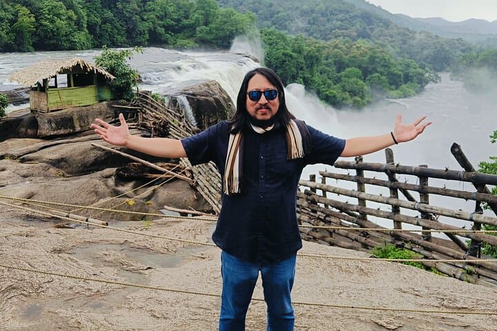


You step out of the air‑conditioned car to the hush of the Western Ghats: sulfurous spray from a wide curtain of water cools the air and the Chalakudy river pulls at the rocks below. Athirappilly’s 84‑foot drop announces itself with a low rumble that seems to push the forest open, and later in the day Cherai’s long sandy spit unfurls into a shallow, swimmer‑friendly sea edged by coconut palms.
You step out of the air‑conditioned car to the hush of the Western Ghats: sulfurous spray from a wide curtain of water cools the air and the Chalakudy river pulls at the rocks below. Athirappilly’s 84‑foot drop announces itself with a low rumble that seems to push the forest open, and later in the day Cherai’s long sandy spit unfurls into a shallow, swimmer‑friendly sea edged by coconut palms.
The route links two very different landscapes: the laterite and gneiss bedrock that channels rain into cascading steps at Vazachal and Charpa, and the Kerala backwaters and Vypin island beaches formed where the sea and river meet. The area has a history tied to timber, spice routes and the local Malabar culture; Chalakudy town and surrounding villages hold traditional fishing and boatbuilding knowledge you’ll glimpse at Munambam and Cherai.
Expect guided stops: Thumboormuzhi hanging bridge and butterfly park for a short walk and photography; the official viewing platforms at Athirappilly (top and a steeper lower trail); then a two‑hour coastal drive to Cherai, arriving by late afternoon for swimming or rental water sports. Practical notes: best water flow after the southwest monsoon (Aug–Feb), limited facilities inside the forest, and steep paths to the bottom viewpoint that can be slippery when wet. Carry drinking water, sturdy shoes for the falls, and swimwear for Cherai — plan the day as a 9–10 hour circuit from Kochi with pickup and drop at your hotel or a central point.