THE ADVENTURE COLLECTIVE® · Independent discovery and booking for outdoor travel

Explore high‑altitude lagoons, flamingo‑studded salt flats and iron‑red stones outside San Pedro de Atacama in a single, well‑paced day. This guided tour mixes geology, village stops and wildlife viewing across the Los Flamencos Reserve.
Explore high‑altitude lagoons, flamingo‑studded salt flats and iron‑red stones outside San Pedro de Atacama in a single, well‑paced day. This guided tour mixes geology, village stops and wildlife viewing across the Los Flamencos Reserve.
You arrive before the sun fully unrolls over the salt plain, the bus engine a soft pulse beneath an immense, cold sky. Air tastes thin; the horizon is a hard seam between ochre desert and distant volcanic cones. The day moves between saline flats where slender flamingos pick like punctuation marks, two deep blue highland lagoons ringed by volcanic ridges, and a shoreline of iron‑stained stones that reads like a geological footnote.
Verified experiences and guided adventures in the surrounding area.
Operated by Enjoy Atacama · San Pedro de Atacama, Antofagasta
You arrive before the sun fully unrolls over the salt plain, the bus engine a soft pulse beneath an immense, cold sky. Air tastes thin; the horizon is a hard seam between ochre desert and distant volcanic cones. The day moves between saline flats where slender flamingos pick like punctuation marks, two deep blue highland lagoons ringed by volcanic ridges, and a shoreline of iron‑stained stones that reads like a geological footnote.
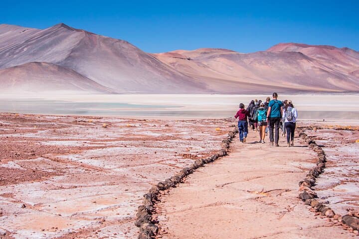
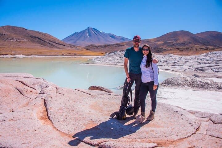
This route crosses the Los Flamencos National Reserve and the altiplanic plateau, territories long inhabited and managed by Atacameño communities. Geologically, you’re on the Andean altiplano: evaporitic basins and volcanic materials left by ancient lakes, now exposed and oxidized into the red hues of Piedras Rojas. Small villages such as Toconao and Socaire carry colonial-era churches and terraced orchards—useful cultural anchors on a landscape shaped by water scarcity and human ingenuity.
Practically, the tour is vehicle-led with short guided walks at each stop: Chaxa in the Salar de Atacama for flamingos, Miscanti and Miñiques at roughly 4,100–4,200 m for panoramic alpine lakes, and the Aguas Calientes/Piedras Rojas area for the red stones. Expect 8–9 hours with roughly 120–160 km of road travel depending on routing. Weather changes fast—sun at altitude is intense; mornings are frigid and afternoons can be windy.
Bring layered clothing, sun protection, a refillable water bottle, and a camera with extra battery—cold shortens charge life. Move deliberately at altitude, hydrate early, and follow guide briefings: these high wetlands are fragile, and staying on trails helps protect bird habitat and native vegetation.
moderate.
8–9 hours.
Suitable for most people who can handle short, gentle walks at high altitude; no heavy hiking required but expect stamina needs due to thin air.
Miscanti and Miñiques are around 4,100–4,200 meters above sea level, so expect thinner air and cooler temperatures.
Yes—Chaxa Lagoon in the Salar de Atacama is a regular feeding site for Andean flamingos, though sightings depend on season and water conditions.
Yes—this full‑day tour typically includes hotel pickup, an air‑conditioned vehicle, breakfast and lunch as part of the package.
Not recommended for very young children under 7 or pregnant travelers due to altitude and remote stops; check operator guidance for age limits.
The altiplano has been stewarded by Atacameño (Likan‑Antay) communities for millennia; villages on the route retain traditional architecture and irrigation practices.
High‑altitude wetlands are fragile: stick to trails, avoid contaminating water sources and follow guide instructions to minimize impact.
Enjoy Atacama operates guided outdoor trips and adventures with an emphasis on safety, stewardship, and memorable experiences.

You arrive before the sun fully unrolls over the salt plain, the bus engine a soft pulse beneath an immense, cold sky. Air tastes thin; the horizon is a hard seam between ochre desert and distant volcanic cones. The day moves between saline flats where slender flamingos pick like punctuation marks, two deep blue highland lagoons ringed by volcanic ridges, and a shoreline of iron‑stained stones that reads like a geological footnote.
You arrive before the sun fully unrolls over the salt plain, the bus engine a soft pulse beneath an immense, cold sky. Air tastes thin; the horizon is a hard seam between ochre desert and distant volcanic cones. The day moves between saline flats where slender flamingos pick like punctuation marks, two deep blue highland lagoons ringed by volcanic ridges, and a shoreline of iron‑stained stones that reads like a geological footnote.
This route crosses the Los Flamencos National Reserve and the altiplanic plateau, territories long inhabited and managed by Atacameño communities. Geologically, you’re on the Andean altiplano: evaporitic basins and volcanic materials left by ancient lakes, now exposed and oxidized into the red hues of Piedras Rojas. Small villages such as Toconao and Socaire carry colonial-era churches and terraced orchards—useful cultural anchors on a landscape shaped by water scarcity and human ingenuity.
Practically, the tour is vehicle-led with short guided walks at each stop: Chaxa in the Salar de Atacama for flamingos, Miscanti and Miñiques at roughly 4,100–4,200 m for panoramic alpine lakes, and the Aguas Calientes/Piedras Rojas area for the red stones. Expect 8–9 hours with roughly 120–160 km of road travel depending on routing. Weather changes fast—sun at altitude is intense; mornings are frigid and afternoons can be windy.
Bring layered clothing, sun protection, a refillable water bottle, and a camera with extra battery—cold shortens charge life. Move deliberately at altitude, hydrate early, and follow guide briefings: these high wetlands are fragile, and staying on trails helps protect bird habitat and native vegetation.