THE ADVENTURE COLLECTIVE® · Independent discovery and booking for outdoor travel

Short hike, long view: Aavasaksa’s low but prominent summit offers historic geodesy, river panoramas and a taste of Finnish–Swedish borderland culture. Read what to expect and how to prepare.
Short hike, long view: Aavasaksa’s low but prominent summit offers historic geodesy, river panoramas and a taste of Finnish–Swedish borderland culture. Read what to expect and how to prepare.
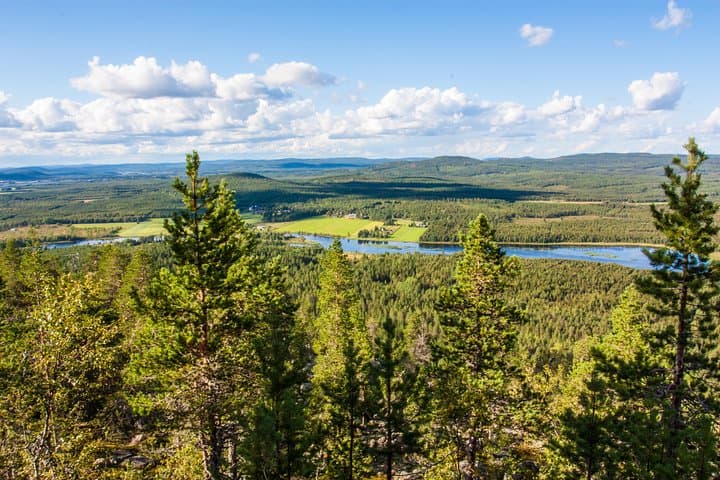
You crest the short, stony rise and the Torne River drops into view: a wide silver ribbon slicing the border between Finland and Sweden. Wind tugs at the pines, and on a clear summer night the sun can linger at the horizon long enough to make the ridge glow. Aavasaksa is compact — a distinct hill above flat forest and rivers — but its position turns modest elevation into an expansive vantage point.
Verified experiences and guided adventures in the surrounding area.
Operated by Helios tour · Ylitornio, Lapland
You crest the short, stony rise and the Torne River drops into view: a wide silver ribbon slicing the border between Finland and Sweden. Wind tugs at the pines, and on a clear summer night the sun can linger at the horizon long enough to make the ridge glow. Aavasaksa is compact — a distinct hill above flat forest and rivers — but its position turns modest elevation into an expansive vantage point.
Geologically the hill is a remnant of post-glacial rebound and resistant bedrock that stands higher than surrounding peatlands. Historically it's famous: Maupertuis used the spot during the 1736–37 French Geodesic Mission, and later it became one of the measured points of the Struve Geodetic Arc; UNESCO recognizes the chain of sites. Culturally the area reflects borderland life — Finnish and Swedish place names, Lutheran churches, and riverside farms that oriented to the Torne's seasonal rhythms.
On the ground expect a short, well-marked walk with rocky trail sections and wooden steps. Vegetation shifts from spruce and birch to low heaths near the summit; on clear days you can see Övertorneå and the braided Torne River. Guides often include barbecue on an open fire and a quick village stop to see the 17th-century Övertorneå church and old station building.
Practical guidance: wear sturdy shoes for uneven rock and roots, bring layers — wind and river chill can be stronger than temperature suggests — and pack water and snacks for a multi-hour outing including transfer time. If you’re traveling in midnight sun season, bring sunglasses and a light mask for sleeping later. Respect marked routes: the site is both geological heritage and fragile northern habitat.
easy.
3–5 hours.
Suitable for most fitness levels; requires ability to walk on uneven ground for up to an hour plus transfer time.
Yes — Aavasaksa is commonly listed as one of the southernmost reliable spots in Finland for midnight sun visibility around late May to mid-July, weather permitting.
No — the primary viewpoint and most trails are on the Finnish side; nearby Övertorneå in Sweden is reachable by road without formal border controls in normal Schengen travel.
The summit walk is short (roughly 20–40 minutes depending on pace) but tours commonly include transfers that make the outing 3–5 hours total.
Facilities are limited; small visitor areas and picnic/fire spots may exist, but plan for minimal services and use village stops for restrooms and food.
Aavasaksa was a key point in 18th–19th century geodesy; Maupertuis’ measurements and the Struve Geodetic Arc built a scientific connection across Europe.
The hill sits on sensitive northern flora and peatland systems—stay on marked trails, avoid trampling low vegetation and follow local fire regulations.
Helios tour operates guided outdoor trips and adventures with an emphasis on safety, stewardship, and memorable experiences.


You crest the short, stony rise and the Torne River drops into view: a wide silver ribbon slicing the border between Finland and Sweden. Wind tugs at the pines, and on a clear summer night the sun can linger at the horizon long enough to make the ridge glow. Aavasaksa is compact — a distinct hill above flat forest and rivers — but its position turns modest elevation into an expansive vantage point.
You crest the short, stony rise and the Torne River drops into view: a wide silver ribbon slicing the border between Finland and Sweden. Wind tugs at the pines, and on a clear summer night the sun can linger at the horizon long enough to make the ridge glow. Aavasaksa is compact — a distinct hill above flat forest and rivers — but its position turns modest elevation into an expansive vantage point.
Geologically the hill is a remnant of post-glacial rebound and resistant bedrock that stands higher than surrounding peatlands. Historically it's famous: Maupertuis used the spot during the 1736–37 French Geodesic Mission, and later it became one of the measured points of the Struve Geodetic Arc; UNESCO recognizes the chain of sites. Culturally the area reflects borderland life — Finnish and Swedish place names, Lutheran churches, and riverside farms that oriented to the Torne's seasonal rhythms.
On the ground expect a short, well-marked walk with rocky trail sections and wooden steps. Vegetation shifts from spruce and birch to low heaths near the summit; on clear days you can see Övertorneå and the braided Torne River. Guides often include barbecue on an open fire and a quick village stop to see the 17th-century Övertorneå church and old station building.
Practical guidance: wear sturdy shoes for uneven rock and roots, bring layers — wind and river chill can be stronger than temperature suggests — and pack water and snacks for a multi-hour outing including transfer time. If you’re traveling in midnight sun season, bring sunglasses and a light mask for sleeping later. Respect marked routes: the site is both geological heritage and fragile northern habitat.