THE ADVENTURE COLLECTIVE® · Independent discovery and booking for outdoor travel

A four-day motorbike loop around Ha Giang takes you over Mã Pì Lèng and across the Dong Van Karst Plateau to meet hill‑tribe villages, sharp passes and wild river views. Expect rough mountain roads, dramatic geology and close cultural encounters.
A four-day motorbike loop around Ha Giang takes you over Mã Pì Lèng and across the Dong Van Karst Plateau to meet hill‑tribe villages, sharp passes and wild river views. Expect rough mountain roads, dramatic geology and close cultural encounters.
You drop the clutch at dawn and the valley exhales — mist lifts off terraced rice and the road snakes up into limestone ribs. Over four days the Ha Giang loop pushes you through hairpin passes, stone villages and the narrow throat of Mã Pì Lèng, where the Nho Que River dares you to look down.
Verified experiences and guided adventures in the surrounding area.
You drop the clutch at dawn and the valley exhales — mist lifts off terraced rice and the road snakes up into limestone ribs. Over four days the Ha Giang loop pushes you through hairpin passes, stone villages and the narrow throat of Mã Pì Lèng, where the Nho Que River dares you to look down.
The route runs across the Dong Van Karst Plateau, a UNESCO Global Geopark carved from ancient limestone and shale. Geology here reads like a slow-motion upheaval: cliffs, potholes and folded ridgelines that shepherd clouds. Culturally, the region is home to Hmong, Dao, Tay and Lo Lo communities; markets and stilt houses reveal living traditions—hand-embroidered jackets, silverwork and seasonal festivals.
Expect roughly 300 km of riding split over four days, with daily legs commonly between 70–120 km. Elevations climb toward 1,200–1,500 m at higher passes; surfaces are mostly paved but can be rough, with short gravel spurs into villages. Weather swings fast—sun, wind and sudden rain reshape the road’s mood.
Practical notes: ride in daylight where visibility is best, carry extra fuel and cash (small shops are frequent but limited), and plan for basic mechanical hiccups. A local guide will smooth language and logistics; bring layered clothing, a rain shell, and solid boots. Move deliberately in villages, ask before photographing people, and give the landscape time—stop at viewpoints, walk the lane into a village and let the day slow around you.
moderate.
4 days (approx. 96 hours).
Comfortable with several hours seated riding per day, steady balance for uneven surfaces, and basic stamina for short walks at altitude.
Local operators usually require an international or local motorcycle license; check with the tour provider and confirm insurance coverage before departure.
Most main sections are paved but can be uneven with potholes; expect short gravel spurs into villages and occasional landslide debris after heavy rain.
Typical nights are in basic guesthouses or homestays in towns such as Dong Van, Mèo Vạc and local villages, with home-cooked regional food and simple amenities.
Elevations are moderate (up to ~1,500 m), so most travelers do fine, but hydrate, avoid heavy exertion on the first day and monitor for headaches or nausea.
The Dong Van Karst Plateau holds millennia of human settlement and was designated a UNESCO Global Geopark for its exceptional karst morphology and cultural landscapes.
Tourism pressure and road widening risk erosion and habitat disturbance; stick to roads, avoid single-use plastics and support community-run homestays.
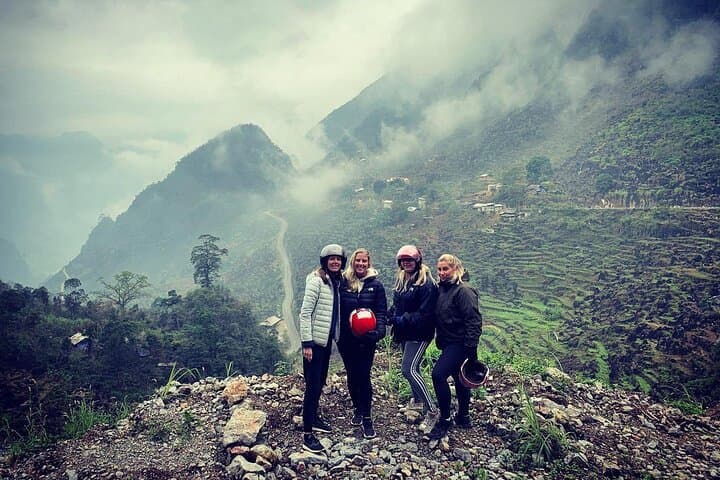
You drop the clutch at dawn and the valley exhales — mist lifts off terraced rice and the road snakes up into limestone ribs. Over four days the Ha Giang loop pushes you through hairpin passes, stone villages and the narrow throat of Mã Pì Lèng, where the Nho Que River dares you to look down.
You drop the clutch at dawn and the valley exhales — mist lifts off terraced rice and the road snakes up into limestone ribs. Over four days the Ha Giang loop pushes you through hairpin passes, stone villages and the narrow throat of Mã Pì Lèng, where the Nho Que River dares you to look down.
The route runs across the Dong Van Karst Plateau, a UNESCO Global Geopark carved from ancient limestone and shale. Geology here reads like a slow-motion upheaval: cliffs, potholes and folded ridgelines that shepherd clouds. Culturally, the region is home to Hmong, Dao, Tay and Lo Lo communities; markets and stilt houses reveal living traditions—hand-embroidered jackets, silverwork and seasonal festivals.
Expect roughly 300 km of riding split over four days, with daily legs commonly between 70–120 km. Elevations climb toward 1,200–1,500 m at higher passes; surfaces are mostly paved but can be rough, with short gravel spurs into villages. Weather swings fast—sun, wind and sudden rain reshape the road’s mood.
Practical notes: ride in daylight where visibility is best, carry extra fuel and cash (small shops are frequent but limited), and plan for basic mechanical hiccups. A local guide will smooth language and logistics; bring layered clothing, a rain shell, and solid boots. Move deliberately in villages, ask before photographing people, and give the landscape time—stop at viewpoints, walk the lane into a village and let the day slow around you.