THE ADVENTURE COLLECTIVE® · Independent discovery and booking for outdoor travel

A three-day motorbike loop that threads Ma Pi Leng Pass, Tu San canyon and Du Gia’s terraces—led by local riders and punctuated with homestays and a boat trip on the Nho Que River. Expect dusty switchbacks, deep gorges, and close cultural encounters with northern Vietnam’s hill communities.
A three-day motorbike loop that threads Ma Pi Leng Pass, Tu San canyon and Du Gia’s terraces—led by local riders and punctuated with homestays and a boat trip on the Nho Que River. Expect dusty switchbacks, deep gorges, and close cultural encounters with northern Vietnam’s hill communities.
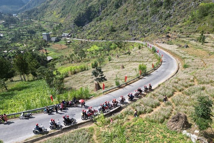
You start before dawn on a narrow ridge road as clouds brush the helmet visor and the engine’s steady thrum becomes your companion. The Ha Giang Loop unfurls over 375 km of switchbacks, karst cliffs and terraced valleys—each hairpin revealing a new, starkly beautiful angle of northern Vietnam.
Verified experiences and guided adventures in the surrounding area.
Operated by TripBestie Ha Giang · Ha Giang, Ha Giang Province
You start before dawn on a narrow ridge road as clouds brush the helmet visor and the engine’s steady thrum becomes your companion. The Ha Giang Loop unfurls over 375 km of switchbacks, karst cliffs and terraced valleys—each hairpin revealing a new, starkly beautiful angle of northern Vietnam.
This route runs along the Dong Van Karst Plateau, an area shaped by ancient limestone uplift and erosion that created steep gorges like Tu San and Ma Pi Leng Pass—the latter a spine-tingling stretch where road and cliff trade places. The region is home to Hmong, Tay and Dao communities; markets in Dong Van and Du Gia still trade in woven textiles and local hill rice, preserving centuries-old cultural rhythms.
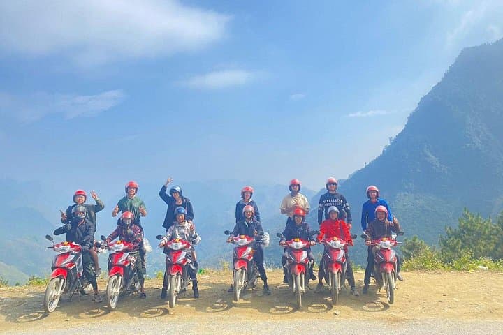
Over three days you’ll ride with a professional local driver, stop for a Nho Que River boat through Tu San canyon, cool off beneath Du Gia’s small waterfall, and sleep in simple homestays or guesthouses. Expect dusty lanes, occasional gravel sections, long stretches on paved mountain roads and sudden weather changes that demand layered clothing.
Practical tips: the tour includes helmets, rain gear and fuel, but bring sturdy shoes, sun protection and a small drybag. Plan for 6–8 hours of riding daily with frequent photo and rest stops; motion sensitivity and limited mobility make parts of the loop uncomfortable. Respect local customs—ask before photographing people—and be prepared to swap city timetables for the slower cadence of highland life. This is a trip that rewards curiosity, steady nerves and basic fitness with some of Vietnam’s most dramatic landscapes.
challenging.
3 days.
Moderate: be comfortable sitting for long periods and managing basic balance on a pillion; not suited to those with serious mobility or back issues
No—each guest is paired with a professional local rider; passengers should be comfortable with long pillion rides but no riding license is required.
Most of the loop is paved but includes narrow, steep sections and occasional gravel; safety is high with an experienced rider, but the route can be physically demanding and exposed.
Nights are in simple guesthouses, hostels or local homestays—shared rooms are common unless you pay for upgrades to private rooms.
Yes—guides can usually arrange vegetarian or simple substitutions; notify the operator at booking for best results.
The Dong Van karst plateau holds millennia of geological history and is designated a UNESCO Global Geopark, with trading towns like Dong Van shaped by hill-tribe commerce routes.
Visitor pressure and road erosion are local concerns—pack out trash, minimize plastic use, and support community homestays to keep tourism benefits local.
TripBestie Ha Giang operates guided outdoor trips and adventures with an emphasis on safety, stewardship, and memorable experiences.

You start before dawn on a narrow ridge road as clouds brush the helmet visor and the engine’s steady thrum becomes your companion. The Ha Giang Loop unfurls over 375 km of switchbacks, karst cliffs and terraced valleys—each hairpin revealing a new, starkly beautiful angle of northern Vietnam.
You start before dawn on a narrow ridge road as clouds brush the helmet visor and the engine’s steady thrum becomes your companion. The Ha Giang Loop unfurls over 375 km of switchbacks, karst cliffs and terraced valleys—each hairpin revealing a new, starkly beautiful angle of northern Vietnam.
This route runs along the Dong Van Karst Plateau, an area shaped by ancient limestone uplift and erosion that created steep gorges like Tu San and Ma Pi Leng Pass—the latter a spine-tingling stretch where road and cliff trade places. The region is home to Hmong, Tay and Dao communities; markets in Dong Van and Du Gia still trade in woven textiles and local hill rice, preserving centuries-old cultural rhythms.
Over three days you’ll ride with a professional local driver, stop for a Nho Que River boat through Tu San canyon, cool off beneath Du Gia’s small waterfall, and sleep in simple homestays or guesthouses. Expect dusty lanes, occasional gravel sections, long stretches on paved mountain roads and sudden weather changes that demand layered clothing.
Practical tips: the tour includes helmets, rain gear and fuel, but bring sturdy shoes, sun protection and a small drybag. Plan for 6–8 hours of riding daily with frequent photo and rest stops; motion sensitivity and limited mobility make parts of the loop uncomfortable. Respect local customs—ask before photographing people—and be prepared to swap city timetables for the slower cadence of highland life. This is a trip that rewards curiosity, steady nerves and basic fitness with some of Vietnam’s most dramatic landscapes.