THE ADVENTURE COLLECTIVE® · Independent discovery and booking for outdoor travel

Three days through Ecuador’s highlands: hike Cotopaxi’s slopes, descend to Quilotoa’s vivid crater lake, and explore Baños’ waterfalls and treehouse vistas. A private, altitude-aware tour that blends geology, local craft villages and active scenery.
Three days through Ecuador’s highlands: hike Cotopaxi’s slopes, descend to Quilotoa’s vivid crater lake, and explore Baños’ waterfalls and treehouse vistas. A private, altitude-aware tour that blends geology, local craft villages and active scenery.
A thin mist peels away from the rim of Quilotoa as you step onto the crater trail, the lake below a bowl of electric turquoise daring you to look closer. Over three days the Andes rearrange themselves beneath your boots: the jagged silhouette of Cotopaxi rising to 5,897 m, the far shoulder of Tungurahua fuming near Baños, and the Avenue of Volcanoes unfurling between indigenous villages where textile looms click in doorways.
Verified experiences and guided adventures in the surrounding area.
Operated by Latin Adventures Cía Ltda · Quito, Pichincha
A thin mist peels away from the rim of Quilotoa as you step onto the crater trail, the lake below a bowl of electric turquoise daring you to look closer. Over three days the Andes rearrange themselves beneath your boots: the jagged silhouette of Cotopaxi rising to 5,897 m, the far shoulder of Tungurahua fuming near Baños, and the Avenue of Volcanoes unfurling between indigenous villages where textile looms click in doorways.
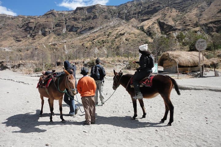
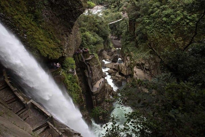
This route traces volcanic geology and living culture. Cotopaxi is a classic stratovolcano built from stacked lava and ash; Quilotoa is a water-filled caldera formed by one of the region’s explosive collapses centuries ago. Local communities around the Quilotoa Loop maintain highland farming traditions and markets selling woven goods and chicha. In Baños the Pastaza River has carved Pailón del Diablo, a plunge that thunders through a narrow gorge and offers spray-cooled air.
Expect variable terrain: bumpy highland roads, steep crater descents of roughly 400–600 m elevation loss at Quilotoa, and multiple short hikes of 1–4 hours at altitude. Altitude is the main challenge — plan for gradual pacing, hydration, and sun protection. Practical choices make the difference: warm layers for night in the paramo, sturdy boots for loose volcanic scree, and a compact daypack for water and rain gear. Early starts minimize afternoon showers and give clearer views of the volcanoes. This compact, private itinerary delivers geological spectacle, hands-on culture, and the small-town adventure energy of Ecuador’s highlands.
moderate.
3 days (approx. 72 hours).
Moderate fitness recommended—able to walk 3–6 hours over uneven ground and handle short steep sections at altitude.
Yes—elevations reach nearly 5,900 m at Cotopaxi and 3,900 m at Quilotoa; mild symptoms are common. Hydrate, ascend slowly, and inform the guide of any issues immediately.
Hikes are mostly day-hike length with variable terrain; participants should be comfortable walking 1–4 hours on uneven trails but technical climbing skills are not required.
The tour operates from Quito with private transport; pickups are typically arranged in the city and the trip returns to Quito on day three.
A minimum of two people per booking is required; the tour is suitable for older children and adults in good health—check operator rules for specific age limits.
The Avenue of Volcanoes corridor has long linked indigenous highland communities; many villages still practice traditional weaving and seasonal agriculture shaped by volcanic soils.
Stick to marked trails in Cotopaxi National Park and avoid feeding wildlife; volcanic soils are fragile—follow leave-no-trace principles and support local guides and community-run enterprises.
Latin Adventures Cía Ltda operates guided outdoor trips and adventures with an emphasis on safety, stewardship, and memorable experiences.


A thin mist peels away from the rim of Quilotoa as you step onto the crater trail, the lake below a bowl of electric turquoise daring you to look closer. Over three days the Andes rearrange themselves beneath your boots: the jagged silhouette of Cotopaxi rising to 5,897 m, the far shoulder of Tungurahua fuming near Baños, and the Avenue of Volcanoes unfurling between indigenous villages where textile looms click in doorways.
A thin mist peels away from the rim of Quilotoa as you step onto the crater trail, the lake below a bowl of electric turquoise daring you to look closer. Over three days the Andes rearrange themselves beneath your boots: the jagged silhouette of Cotopaxi rising to 5,897 m, the far shoulder of Tungurahua fuming near Baños, and the Avenue of Volcanoes unfurling between indigenous villages where textile looms click in doorways.
This route traces volcanic geology and living culture. Cotopaxi is a classic stratovolcano built from stacked lava and ash; Quilotoa is a water-filled caldera formed by one of the region’s explosive collapses centuries ago. Local communities around the Quilotoa Loop maintain highland farming traditions and markets selling woven goods and chicha. In Baños the Pastaza River has carved Pailón del Diablo, a plunge that thunders through a narrow gorge and offers spray-cooled air.
Expect variable terrain: bumpy highland roads, steep crater descents of roughly 400–600 m elevation loss at Quilotoa, and multiple short hikes of 1–4 hours at altitude. Altitude is the main challenge — plan for gradual pacing, hydration, and sun protection. Practical choices make the difference: warm layers for night in the paramo, sturdy boots for loose volcanic scree, and a compact daypack for water and rain gear. Early starts minimize afternoon showers and give clearer views of the volcanoes. This compact, private itinerary delivers geological spectacle, hands-on culture, and the small-town adventure energy of Ecuador’s highlands.