THE ADVENTURE COLLECTIVE® · Independent discovery and booking for outdoor travel

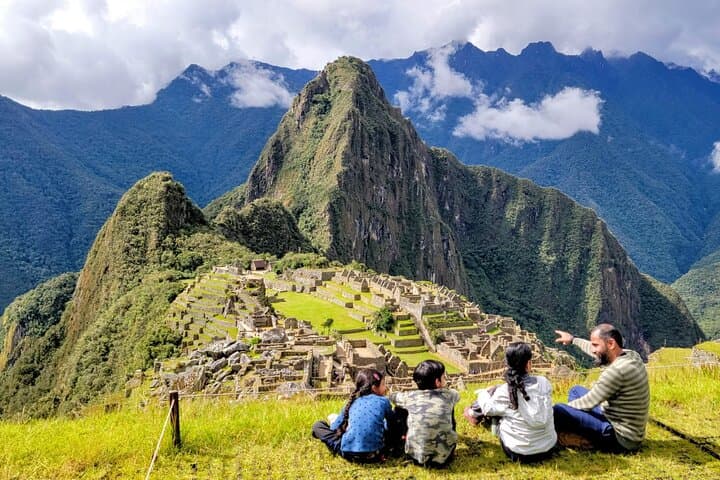
A compact, two-day version of the classic Inca Trail that starts at Km 104 and delivers Wiñaywayna, the Sun Gate viewpoint and an afternoon in Machu Picchu—perfect for travelers short on time but hungry for the full trail experience.
A compact, two-day version of the classic Inca Trail that starts at Km 104 and delivers Wiñaywayna, the Sun Gate viewpoint and an afternoon in Machu Picchu—perfect for travelers short on time but hungry for the full trail experience.
Before dawn a minivan slips through the sleeping streets of Cusco, and by first light the train threads the Vilcanota River valley toward Km 104. The trail begins with a bridge over the Urubamba and a passport check that makes clear this is an archaeological passage, not just a footpath. The route climbs through cloud-shadowed eucalyptus and stands of Polylepis, rising toward terraced stonework and the agricultural complex of Wiñaywayna.
Verified experiences and guided adventures in the surrounding area.
Operated by Machupicchu Latin America · Aguas Calientes, Cusco
Before dawn a minivan slips through the sleeping streets of Cusco, and by first light the train threads the Vilcanota River valley toward Km 104. The trail begins with a bridge over the Urubamba and a passport check that makes clear this is an archaeological passage, not just a footpath. The route climbs through cloud-shadowed eucalyptus and stands of Polylepis, rising toward terraced stonework and the agricultural complex of Wiñaywayna.
This short Inca Trail compresses centuries of engineering into a single day: finely cut staircases, water channels that still run, and the sequence of niches and plazas designed to frame approach to Machu Picchu. Geologically, the Andes here are folded volcanic and sedimentary slopes carved by the Vilcanota; the trail clings to narrow ledges and switchbacks that reward persistence with sudden panoramas. Culturally, guides point out Quechua place names and the Inca emphasis on sacred water and sightlines—the Sun Gate (Inti Punku) was an arrival threshold deliberately aligned with Machu Picchu’s core.
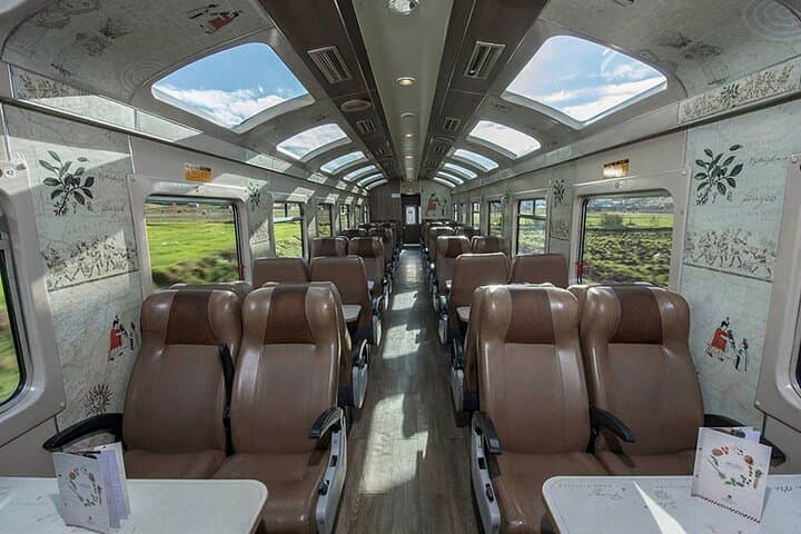
Practically: expect roughly 10 km of trail from Km 104 to Machu Picchu with ~400–500 m of net ascent spread over 3–4 hours to Wiñaywayna and the Sun Gate, then a descending hour to the citadel. Permit and passport checks are strict; bring layered clothing for rapid weather shifts, 2–3 liters of water, and sturdy boots with good traction. Allow 48–72 hours in Cusco beforehand to acclimatize to 3,400 m altitude. Time your visit for early arrival at the Sun Gate to beat crowds—then finish with a guided afternoon tour and a scenic Vistadome train back to the Sacred Valley.
moderate.
2 days (≈6–8 hours hiking spread over Day 1).
Moderate fitness required—comfortable with sustained uphill hiking and stair sections.
Yes—access is regulated and permits tied to your passport are checked at Km 104; tour operators handle booking but you must carry the same passport.
Expect roughly 3–4 hours uphill to Wiñaywayna and the Sun Gate (about 10 km total to Machu Picchu), with varied stone steps—rated moderate for fitness and endurance.
Yes—Cusco sits around 3,400 m. Spend 1–3 days acclimatizing, avoid alcohol, hydrate well and consider light walks before attempting the trail.
The itinerary includes an afternoon guided tour of Machu Picchu, a night in Aguas Calientes, and a panoramic Vistadome train back toward Ollantaytambo and Cusco.
The Inca Trail network was both ceremonial and practical—paths like the Km 104 route linked agricultural centers, tambo (way stations) and the royal estate at Machu Picchu.
Permits limit daily visitors to protect the fragile stonework and montane vegetation; stick to trails, carry out waste and follow guide instructions to minimize impact.
Machupicchu Latin America operates guided outdoor trips and adventures with an emphasis on safety, stewardship, and memorable experiences.


Before dawn a minivan slips through the sleeping streets of Cusco, and by first light the train threads the Vilcanota River valley toward Km 104. The trail begins with a bridge over the Urubamba and a passport check that makes clear this is an archaeological passage, not just a footpath. The route climbs through cloud-shadowed eucalyptus and stands of Polylepis, rising toward terraced stonework and the agricultural complex of Wiñaywayna.
Before dawn a minivan slips through the sleeping streets of Cusco, and by first light the train threads the Vilcanota River valley toward Km 104. The trail begins with a bridge over the Urubamba and a passport check that makes clear this is an archaeological passage, not just a footpath. The route climbs through cloud-shadowed eucalyptus and stands of Polylepis, rising toward terraced stonework and the agricultural complex of Wiñaywayna.
This short Inca Trail compresses centuries of engineering into a single day: finely cut staircases, water channels that still run, and the sequence of niches and plazas designed to frame approach to Machu Picchu. Geologically, the Andes here are folded volcanic and sedimentary slopes carved by the Vilcanota; the trail clings to narrow ledges and switchbacks that reward persistence with sudden panoramas. Culturally, guides point out Quechua place names and the Inca emphasis on sacred water and sightlines—the Sun Gate (Inti Punku) was an arrival threshold deliberately aligned with Machu Picchu’s core.
Practically: expect roughly 10 km of trail from Km 104 to Machu Picchu with ~400–500 m of net ascent spread over 3–4 hours to Wiñaywayna and the Sun Gate, then a descending hour to the citadel. Permit and passport checks are strict; bring layered clothing for rapid weather shifts, 2–3 liters of water, and sturdy boots with good traction. Allow 48–72 hours in Cusco beforehand to acclimatize to 3,400 m altitude. Time your visit for early arrival at the Sun Gate to beat crowds—then finish with a guided afternoon tour and a scenic Vistadome train back to the Sacred Valley.