THE ADVENTURE COLLECTIVE® · Independent discovery and booking for outdoor travel

A two-day, one-night guided trek from Sembalun to Mount Rinjani’s 3,726 m summit, combining steep volcanic climbs, a crater-rim camp and a pre-dawn summit push for sunrise. Expect scree, long meadow crossings and panoramic island views.
A two-day, one-night guided trek from Sembalun to Mount Rinjani’s 3,726 m summit, combining steep volcanic climbs, a crater-rim camp and a pre-dawn summit push for sunrise. Expect scree, long meadow crossings and panoramic island views.
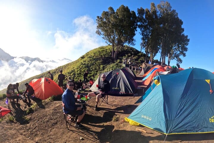
Dawn on the Sembalun plain begins cool and blade-sharp; headlamps fade as a ribbon of hikers threads up stony switchbacks toward the crater rim. Day one climbs from roughly 1,150 m through sun-baked meadows and a series of five steep ridges to Pelawangan Sembalun at 2,639 m, where tents gather on the crater lip and Segara Anak Lake sits like a dark eye below.
Verified experiences and guided adventures in the surrounding area.
Operated by Rinjani Hero · Sembalun, West Nusa Tenggara
Dawn on the Sembalun plain begins cool and blade-sharp; headlamps fade as a ribbon of hikers threads up stony switchbacks toward the crater rim. Day one climbs from roughly 1,150 m through sun-baked meadows and a series of five steep ridges to Pelawangan Sembalun at 2,639 m, where tents gather on the crater lip and Segara Anak Lake sits like a dark eye below.
Rinjani is a young volcanic giant in West Nusa Tenggara with a caldera carved by explosive eruptions; its rim and inner crater reveal recent lava flows and ash deposits. The Sembalun approach crosses volcanic scree, grassy savanna used seasonally for grazing, and traditional Sasak villages where agriculture and mountain guiding are parts of daily life.
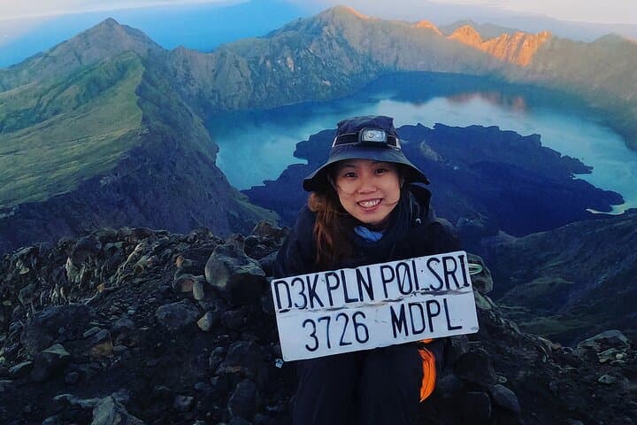
Expect mixed terrain: long, exposed meadow crossings; steep, sustained climbs; and loose volcanic scree near the summit. The summit push starts around 02:30–03:00 to reach sunrise at 3,726 m — the last hour can feel like two steps forward, one back on shifting rock. Weather can shift quickly; clear mornings give views to Lombok, Bali, and distant Sumbawa.
Practical guidance: carry layers for cold at altitude, bring ≥2 liters of water with electrolytes, and use trekking poles on the descent. Acclimatize if possible, pace conservatively on the steep sections, and rely on an experienced guide — permit and porter logistics are handled on-route for most operators. With preparation, this two-day itinerary rewards you with a raw summit and crater-rim panoramas that define high-altitude tropical trekking.
challenging.
2 days (roughly 8–10 hours hiking day 1, 7–9 hours day 2 including summit and descent).
Good cardiovascular fitness and strong leg endurance; comfortable with sustained uphill hiking and steep, loose terrain.
Prior high-altitude trekking experience helps; while technical climbing skills aren’t required, strong fitness and experience with long ascents and scree are recommended.
Most operators include park registration, a licensed guide and porters; confirm specifics with your provider before departure.
The dry season (June–September) offers the most reliable weather and clearest summit views; avoid the monsoon season (Dec–Feb) for safety reasons.
Summit altitude (3,726 m) can provoke acute mountain sickness in susceptible people—acclimatize, ascend slowly, stay hydrated, and know signs for descent or medical care.
Rinjani’s caldera formed in explosive eruptions; the inner Segara Anak Lake and small volcanic cone reflect the island’s active geological past and local Sasak sacred traditions.
Rinjani National Park regulates trekking permits and limits camping to designated rims; stay on trails, pack out waste and use local guides to support sustainable access.
Rinjani Hero operates guided outdoor trips and adventures with an emphasis on safety, stewardship, and memorable experiences.
Dawn on the Sembalun plain begins cool and blade-sharp; headlamps fade as a ribbon of hikers threads up stony switchbacks toward the crater rim. Day one climbs from roughly 1,150 m through sun-baked meadows and a series of five steep ridges to Pelawangan Sembalun at 2,639 m, where tents gather on the crater lip and Segara Anak Lake sits like a dark eye below.
Dawn on the Sembalun plain begins cool and blade-sharp; headlamps fade as a ribbon of hikers threads up stony switchbacks toward the crater rim. Day one climbs from roughly 1,150 m through sun-baked meadows and a series of five steep ridges to Pelawangan Sembalun at 2,639 m, where tents gather on the crater lip and Segara Anak Lake sits like a dark eye below.
Rinjani is a young volcanic giant in West Nusa Tenggara with a caldera carved by explosive eruptions; its rim and inner crater reveal recent lava flows and ash deposits. The Sembalun approach crosses volcanic scree, grassy savanna used seasonally for grazing, and traditional Sasak villages where agriculture and mountain guiding are parts of daily life.
Expect mixed terrain: long, exposed meadow crossings; steep, sustained climbs; and loose volcanic scree near the summit. The summit push starts around 02:30–03:00 to reach sunrise at 3,726 m — the last hour can feel like two steps forward, one back on shifting rock. Weather can shift quickly; clear mornings give views to Lombok, Bali, and distant Sumbawa.
Practical guidance: carry layers for cold at altitude, bring ≥2 liters of water with electrolytes, and use trekking poles on the descent. Acclimatize if possible, pace conservatively on the steep sections, and rely on an experienced guide — permit and porter logistics are handled on-route for most operators. With preparation, this two-day itinerary rewards you with a raw summit and crater-rim panoramas that define high-altitude tropical trekking.